
USGS research geologist Kate Scharer with her finger on the Fairweather Fault in southeast Alaska. The magnitude 7.8 Lituya Bay earthquake caused shaking that toppled trees along the fault, which left a break in the forest shown here.
Images
Images
Filter Total Items: 9449

Fairweather Fault
USGS research geologist Kate Scharer with her finger on the Fairweather Fault in southeast Alaska. The magnitude 7.8 Lituya Bay earthquake caused shaking that toppled trees along the fault, which left a break in the forest shown here.

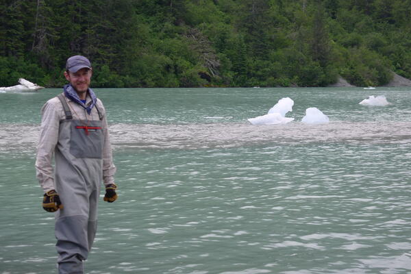
South Crillon Glacier
Periodic calving of ice from the snout of South Crillon Glacier.
Periodic calving of ice from the snout of South Crillon Glacier.
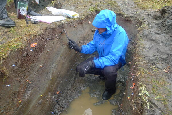
2016 Fairweather Fault trenching
The team’s work included excavating trenches across the fault to examine layers of sediment.
The team’s work included excavating trenches across the fault to examine layers of sediment.
Chris DuRoss
USGS research geologist Chris DuRoss gaging ice for the icebox required more than a pair of waders.
USGS research geologist Chris DuRoss gaging ice for the icebox required more than a pair of waders.

South Crillon Glacier
Nearly 60 years after a magnitude 7.7 earthquake struck Lituya Bay, Alaska — leading to a tsunami that devastated the area — six U.S. Geological Survey geologists revisited the isolated region of Alaska, to pick up where their scientific predecessors left off.
Nearly 60 years after a magnitude 7.7 earthquake struck Lituya Bay, Alaska — leading to a tsunami that devastated the area — six U.S. Geological Survey geologists revisited the isolated region of Alaska, to pick up where their scientific predecessors left off.
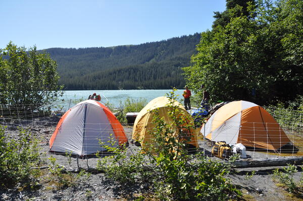
Campsite near Crillon Lake
The USGS field team camped out near Crillon Lake for the 10-day expedition.
The USGS field team camped out near Crillon Lake for the 10-day expedition.
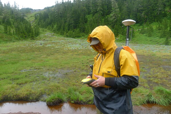
New technology furthers Fairweather fault research
New technology furthers Fairweather fault researchScientists use current technology to further Fairweather Fault research.
New technology furthers Fairweather fault research
New technology furthers Fairweather fault researchScientists use current technology to further Fairweather Fault research.

Sarah Hawkins Receives the Core
USGS scientist Sarah Hawkins, lead scientist for the Mancos Shale assessment, examining a core drilled by the USGS Core Research Center. This core provided valuable data for the assessment. Image credit: Joshua Hicks, USGS.
USGS scientist Sarah Hawkins, lead scientist for the Mancos Shale assessment, examining a core drilled by the USGS Core Research Center. This core provided valuable data for the assessment. Image credit: Joshua Hicks, USGS.

Research Drilling Rig and Landscape
The USGS Core Research Center collaborated with the USGS Energy Resources Program to drill a core from the Mancos Shale to aid in the oil and gas assessment. Image Credit: Joshua Hicks, USGS.
The USGS Core Research Center collaborated with the USGS Energy Resources Program to drill a core from the Mancos Shale to aid in the oil and gas assessment. Image Credit: Joshua Hicks, USGS.

Inspecting Permafrost
USGS scientist Neal Pastick inspects a permafrost plot in North Slope of Alaska near Galbraith Lake.
USGS scientist Neal Pastick inspects a permafrost plot in North Slope of Alaska near Galbraith Lake.

Great Basin
The Great Basin area in the northern Snake Range near the Utah/Nevada boarder.
The Great Basin area in the northern Snake Range near the Utah/Nevada boarder.

Great Basin
The Great Basin area in the northern Snake Range near the Utah/Nevada boarder.
The Great Basin area in the northern Snake Range near the Utah/Nevada boarder.

Great Basin
The Great Basin area in the northern Snake Range near the Utah/Nevada boarder.
The Great Basin area in the northern Snake Range near the Utah/Nevada boarder.

Great Basin
The Great Basin area in the northern Snake Range near the Utah/Nevada boarder.
The Great Basin area in the northern Snake Range near the Utah/Nevada boarder.

The USGS Coal Assessment Project
Coal project personnel visiting Trapper Mine in northwest Colorado in June, 2016.
Coal project personnel visiting Trapper Mine in northwest Colorado in June, 2016.

Great Basin
The Great Basin area in the northern Snake Range near the Utah/Nevada boarder.
The Great Basin area in the northern Snake Range near the Utah/Nevada boarder.

Temporary Streamgage on Brazos River
USGS scientist Jody Avant installs a temporary streamgage on the Brazos River near West Columbia, Texas. Rapidly deployable streamgages can be installed temporarily to provide emergency managers with additional information needed to help protect public safety.
USGS scientist Jody Avant installs a temporary streamgage on the Brazos River near West Columbia, Texas. Rapidly deployable streamgages can be installed temporarily to provide emergency managers with additional information needed to help protect public safety.

Temporary Streamgage on Brazos River
Temporary streamgage installed by the USGS on the Brazos River near Brazoria, Texas. Rapidly deployable streamgages can be installed temporarily to provide emergency managers with additional information needed to help protect public safety.
Temporary streamgage installed by the USGS on the Brazos River near Brazoria, Texas. Rapidly deployable streamgages can be installed temporarily to provide emergency managers with additional information needed to help protect public safety.

Stan Musial bridge in St. Louis, Missouri
Photo of the Stan Musial bridge in St. Louis, Missouri.
Photo of the Stan Musial bridge in St. Louis, Missouri.

A piping plover adult standing over a nest scrape with four eggs
A piping plover adult standing over a nest scrape with four eggsA piping plover adult standing over a nest scrape with four eggs. Photo was taken on the Garrison Reach of the Missouri River, North Dakota
A piping plover adult standing over a nest scrape with four eggs
A piping plover adult standing over a nest scrape with four eggsA piping plover adult standing over a nest scrape with four eggs. Photo was taken on the Garrison Reach of the Missouri River, North Dakota

Piping plover adult stands on a sandbar
A piping plover adult stands on a sandbar on the Garrison Reach of the Missouri River, North Dakota. The yellow alphanumeric leg flag and color bands that identify it are clearly visible.
A piping plover adult stands on a sandbar on the Garrison Reach of the Missouri River, North Dakota. The yellow alphanumeric leg flag and color bands that identify it are clearly visible.