
At the USGS Cascades Volcano Observatory Electronics Lab, technicians build, test, and prepare scientific instruments to be deployed for monitoring volcanoes worldwide.
Images
Images
Filter Total Items: 9449

Cascades Volcano Observatory Electronics Lab
At the USGS Cascades Volcano Observatory Electronics Lab, technicians build, test, and prepare scientific instruments to be deployed for monitoring volcanoes worldwide.

USGS Seismometer
Seismometers (instruments for recording earthquakes) are tested and fitted at the USGS Cascades Volcano Observatory before going out into the field.
Seismometers (instruments for recording earthquakes) are tested and fitted at the USGS Cascades Volcano Observatory before going out into the field.

Volcano Monitoring Equipment Cache
The Volcano Distater Assistance Program (VDAP) maintains an equipment cache located at the USGSS Cascades Volcano Observatory. The volcano monitoring equipment can be rapidly deployed worldwide when needed.
The Volcano Distater Assistance Program (VDAP) maintains an equipment cache located at the USGSS Cascades Volcano Observatory. The volcano monitoring equipment can be rapidly deployed worldwide when needed.

Sea Otters
Three of the nine wild sea otter populations in the U.S. are federally listed as threatened. In California, USGS biologists have lead an annual population census to assess the local populations' recovery, working closely with state agencies and the Monterey Bay Aquarium.
Three of the nine wild sea otter populations in the U.S. are federally listed as threatened. In California, USGS biologists have lead an annual population census to assess the local populations' recovery, working closely with state agencies and the Monterey Bay Aquarium.

Pipe installation to monitor harmful algal blooms at Cheney Reservoir
Pipe installation to monitor harmful algal blooms at Cheney ReservoirJohn Rosendale installs a pipe to monitor harmful algal blooms at Cheney Reservoir in Kansas.
Pipe installation to monitor harmful algal blooms at Cheney Reservoir
Pipe installation to monitor harmful algal blooms at Cheney ReservoirJohn Rosendale installs a pipe to monitor harmful algal blooms at Cheney Reservoir in Kansas.

Streamgage in Connecticut
A beautiful capture of a streamgage at Bunnell Brook near Burlington, CT.

Rio Brazos near Tierra Amarilla, NM
Hydrologic technician Lindsay Hastings took this photo of the Rio Brazos near Tierra Amarilla, New Mexico during her first field trip as a streamgager with the New Mexico Water Science Center. Did you know that New Mexico was the birth place of streamgaging?
Hydrologic technician Lindsay Hastings took this photo of the Rio Brazos near Tierra Amarilla, New Mexico during her first field trip as a streamgager with the New Mexico Water Science Center. Did you know that New Mexico was the birth place of streamgaging?
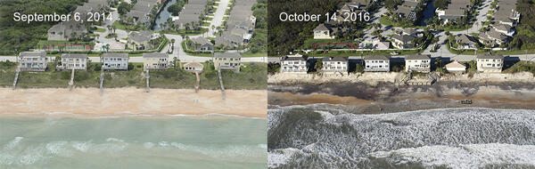
Vilano Beach, FL: Dunes, decks and boardwalks swept away
Vilano Beach, FL: Dunes, decks and boardwalks swept awayVilano Beach, FL: Low altitude oblique aerial photographs taken before Hurricane Matthew (Sept. 6, 2014) and after (Oct. 14, 2016) show that storm waves and currents eroded a 16-foot-high san dune, exposing old seawalls and washing away boardwalks and decks.
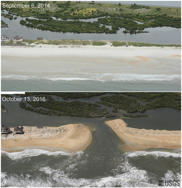
St. Augustine: storm waves wipe out dune, open new inlet
St. Augustine: storm waves wipe out dune, open new inletLow-altitude oblique photography taken before Hurricane Matthew (Sept. 6, 2014) and after (Oct. 13, 2016) shows the storm cut a new inlet between the Atlantic Ocean and the Matanzas River, stripping away a 3.7 meter (12-foot) dune and carrying sand into the estuary.

Flagler Beach: Highway A1A partly destroyed
Low-altitude oblique photography taken before Hurricane Matthew (Sept. 6, 2014) and after (Oct. 13, 2016) in Flagler Beach, FL, shows that waves washed away part of Highway A1A and obliterated a 5.2-meter (17-foot) dune.
Low-altitude oblique photography taken before Hurricane Matthew (Sept. 6, 2014) and after (Oct. 13, 2016) in Flagler Beach, FL, shows that waves washed away part of Highway A1A and obliterated a 5.2-meter (17-foot) dune.

Nature's Balance — Schwabacher's Landing
This was an early morning capture as the sun was rising at Schwabacher's Landing, Wyoming. The heavy cloud cover shielded the Grand Tetons from full view, but as we sat there, a small sliver of the mountains peeked through the clouds just long enough to take a few shots.
This was an early morning capture as the sun was rising at Schwabacher's Landing, Wyoming. The heavy cloud cover shielded the Grand Tetons from full view, but as we sat there, a small sliver of the mountains peeked through the clouds just long enough to take a few shots.

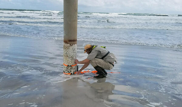
USGS storm-tide sensor
This U.S. Geological Survey storm-tide sensor was installed on a pier pylon near Big Talbot Island State Park in Duval County, Florida, in preparation for Hurricane Matthew's arrival.
This U.S. Geological Survey storm-tide sensor was installed on a pier pylon near Big Talbot Island State Park in Duval County, Florida, in preparation for Hurricane Matthew's arrival.

Grand Tetons
A shot taken from the walkway behind the Jackson Lake Lodge in Grand Teton National Park, Wyoming.
A shot taken from the walkway behind the Jackson Lake Lodge in Grand Teton National Park, Wyoming.

Installing a rapid deployment gauge to track Hurricane Matthew impacts
Installing a rapid deployment gauge to track Hurricane Matthew impactsUSGS hydrologic technician Jym Chapman (above) installs a rapid deployment gauge to measure water-surface elevation and other data in Myrtle Beach, South Carolina, prior to Hurricane Matthew’s approach in October 2016. Hydrologist Tim Pojunas (below) measures an elevation reference point used to calibrate the newly installed RDG.
Storm-tide sensor installation
Ryan Patrick, USGS hydrologist, installs a storm-tide sensor in preparation for Hurricane Matthew. The data collected by these sensors is used to create better storm-tide models, more accurate flood forecasts, more effective flood-protection infrastructure, and wiser land use policies.
Ryan Patrick, USGS hydrologist, installs a storm-tide sensor in preparation for Hurricane Matthew. The data collected by these sensors is used to create better storm-tide models, more accurate flood forecasts, more effective flood-protection infrastructure, and wiser land use policies.

View from Canyonlands Research Center
View from Canyonlands Research Center.

Biocrust
On the Colorado Plateau, mature biocrusts are bumpy and dark-colored due to the presence of lichens, mosses, and high densities of cyanobacteria and other organisms. Disturbed biocrusts are lighter in color, looking more like the underlying sand than undisturbed ones, and are less capable of stabilizing soils or providing soil fertility.
On the Colorado Plateau, mature biocrusts are bumpy and dark-colored due to the presence of lichens, mosses, and high densities of cyanobacteria and other organisms. Disturbed biocrusts are lighter in color, looking more like the underlying sand than undisturbed ones, and are less capable of stabilizing soils or providing soil fertility.

USGS scientist Jayne Belnap examines instruments to measure biocrust
USGS scientist Jayne Belnap examines instruments to measure biocrustUSGS scientist Jayne Belnap examines instrumentation to measure photosynthetic rates of biocrusts.
USGS scientist Jayne Belnap examines instruments to measure biocrust
USGS scientist Jayne Belnap examines instruments to measure biocrustUSGS scientist Jayne Belnap examines instrumentation to measure photosynthetic rates of biocrusts.

Footprint damage to biocrusts
Many human activities can be unintentionally harmful to biological crusts. The biocrusts are no match for the compressional stress caused by footprints of livestock or people or tracks from vehicles.
Many human activities can be unintentionally harmful to biological crusts. The biocrusts are no match for the compressional stress caused by footprints of livestock or people or tracks from vehicles.

Dark-colored mature biocrust
On the Colorado Plateau, mature biocrusts are bumpy and dark-colored due to the presence of lichens, mosses, and high densities of cyanobacteria and other organisms. These organisms perform critical functions, such as fertilizing soils and increasing soil stability, therefore reducing dust.
On the Colorado Plateau, mature biocrusts are bumpy and dark-colored due to the presence of lichens, mosses, and high densities of cyanobacteria and other organisms. These organisms perform critical functions, such as fertilizing soils and increasing soil stability, therefore reducing dust.

Using radio telemetry
Don Ashton uses radio telemetry to track a federally threatened Oregon spotted frog (Rana pretiosa). Data provide information on resource use, movement patterns, and overwintering
Don Ashton uses radio telemetry to track a federally threatened Oregon spotted frog (Rana pretiosa). Data provide information on resource use, movement patterns, and overwintering