PubTalk 5/2017 — Underwater secrets of the Hayward fault zone
PubTalk 5/2017 — Underwater secrets of the Hayward fault zoneTitle: Underwater Secrets of the Hayward Fault Zone: Integrated 3D imaging to understand earthquake hazards

Official websites use .gov
A .gov website belongs to an official government organization in the United States.
Secure .gov websites use HTTPS
A lock () or https:// means you’ve safely connected to the .gov website. Share sensitive information only on official, secure websites.
Surface rupture occurs when movement on a fault deep within the earth breaks through to the surface. NOT ALL earthquakes result in surface rupture.

An earthquake is caused by a sudden slip on a fault. The tectonic plates are always slowly moving, but they get stuck at their edges due to friction. When the stress on the edge overcomes the friction, there is an earthquake that releases energy in waves that travel through the earth's crust and cause the shaking that we feel. In California there are two plates - the Pacific Plate and the North...
"Foreshock" and "aftershock" are relative terms. Foreshocks are earthquakes that precede larger earthquakes in the same location. An earthquake cannot be identified as a foreshock until after a larger earthquake in the same area occurs. Aftershocks are smaller earthquakes that occur in the same general area during the days to years following a larger event or "mainshock." They occur within 1-2...
Earthquakes are equally as likely to occur in the morning or the evening. Many studies in the past have shown no significant correlations between the rate of earthquake occurrence and the semi-diurnal tides when using large earthquake catalogs. Several recent studies, however, have found a correlation between earth tides (caused by the position of the moon relative to the earth) and some types of...

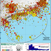
Earthquakes occur in the crust or upper mantle, which ranges from the earth's surface to about 800 kilometers deep (about 500 miles). The strength of shaking from an earthquake diminishes with increasing distance from the earthquake's source, so the strength of shaking at the surface from an earthquake that occurs at 500 km deep is considerably less than if the same earthquake had occurred at 20...
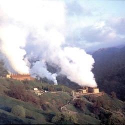
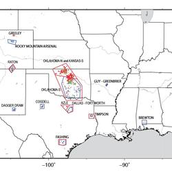
The Geysers Geothermal Field is located in a tectonically active region of Northern California. The major seismic hazards in the region are from large earthquakes occurring along regional faults that are located miles away from the geothermal field, such as the San Andreas and Healdsburg-Rodgers Creek faults. However, activities associated with the withdrawal of steam for producing electric power...

Earthquakes do occur in Antarctica, but not very often. There have been some big earthquakes--including one magnitude 8.1--in the Balleny Islands (between Antarctica and New Zealand). The boundary between the Scotia Plate and the Antarctic Plate just grazes the north tip of the Antarctic Peninsula (look "northwest" from the Pole toward South America). There is also a hint of a line of seismicity...
Start with our Earthquake Hazards Education site. That includes: Earthquakes for Kids Cool Earthquake Facts Earthquake Science for Everyone Other good starting points include: State Geological Surveys for states in earthquake-prone regions The Great ShakeOut Earthquake Drills website SAGE (Seismological Facility for the Advancement of Geoscience), which is a non-profit consortium
Earthquakes induced by human activity have been documented at many locations in the United States and in many other countries around the world. Earthquakes can be induced by a wide range of causes including impoundment of reservoirs, surface and underground mining, withdrawal of fluids and gas from the subsurface, and injection of fluids into underground formations. While most induced earthquakes...
Aftershocks are a sequence of earthquakes that happen after a larger mainshock on a fault. Aftershocks occur near the fault zone where the mainshock rupture occurred and are part of the "readjustment process” after the main slip on the fault. Aftershocks become less frequent with time, although they can continue for days, weeks, months, or even years for a very large mainshock. A swarm, on the...

Title: Underwater Secrets of the Hayward Fault Zone: Integrated 3D imaging to understand earthquake hazards
Title: Underwater Secrets of the Hayward Fault Zone: Integrated 3D imaging to understand earthquake hazards

Pavement buckling and tented sidewalk resulting from ~14 cm of compression on Sandybrook Ln., north end of main rupture.
Pavement buckling and tented sidewalk resulting from ~14 cm of compression on Sandybrook Ln., north end of main rupture.

Photograph of surface fractures along fault south of Pinto Wash; view to the northeast.
Photograph of surface fractures along fault south of Pinto Wash; view to the northeast.

Vertical surface fractures along Ocotillo Fault. Faulting here is associated with the nearby Mw5.7 aftershock of June 14, 2010. Tape measure for scale.
Vertical surface fractures along Ocotillo Fault. Faulting here is associated with the nearby Mw5.7 aftershock of June 14, 2010. Tape measure for scale.

Fault scarp (above change in slope) with fractures (white arrows) along Yuha Fault; view to the northwest. Yellow notebook (in center) for scale.
Fault scarp (above change in slope) with fractures (white arrows) along Yuha Fault; view to the northwest. Yellow notebook (in center) for scale.

Fresh surface fractures (black arrows) along Brawley Fault Zone and across Ralph Road in response to the 2010 El Mayor-Cucapah earthquake; view to the north. Slight vertical component of slip (2 mm, up on east [right] side) more noticeable at white arrow.
Fresh surface fractures (black arrows) along Brawley Fault Zone and across Ralph Road in response to the 2010 El Mayor-Cucapah earthquake; view to the north. Slight vertical component of slip (2 mm, up on east [right] side) more noticeable at white arrow.

The Denali fault offset crevasses on the Canwell Glacier.
The Denali fault offset crevasses on the Canwell Glacier.

View southeast along the Totschunda fault.
View southeast along the Totschunda fault.

Near the southeast extent of the surface rupture of the Totschunda fault thrust faulting pushed the frozen sand and gravel over the snow surface.
Near the southeast extent of the surface rupture of the Totschunda fault thrust faulting pushed the frozen sand and gravel over the snow surface.

At pass west of Delta River. Here there was roughly 5 m of offset. Note the push up in the background. There is permafrost at the bottom of the cracks.
At pass west of Delta River. Here there was roughly 5 m of offset. Note the push up in the background. There is permafrost at the bottom of the cracks.

Wendy McCausland of the USGS Volcano Disaster Assistance Program and Hani Zahran of the Saudi Geological Survey view the southern end of the surface fault rupture caused by a M5.4 earthquake in the Saudi Arabian desert on May 19, 2009.
Wendy McCausland of the USGS Volcano Disaster Assistance Program and Hani Zahran of the Saudi Geological Survey view the southern end of the surface fault rupture caused by a M5.4 earthquake in the Saudi Arabian desert on May 19, 2009.
An earthquake is caused by a sudden slip on a fault. The tectonic plates are always slowly moving, but they get stuck at their edges due to friction. When the stress on the edge overcomes the friction, there is an earthquake that releases energy in waves that travel through the earth's crust and cause the shaking that we feel. In California there are two plates - the Pacific Plate and the North...
"Foreshock" and "aftershock" are relative terms. Foreshocks are earthquakes that precede larger earthquakes in the same location. An earthquake cannot be identified as a foreshock until after a larger earthquake in the same area occurs. Aftershocks are smaller earthquakes that occur in the same general area during the days to years following a larger event or "mainshock." They occur within 1-2...
Earthquakes are equally as likely to occur in the morning or the evening. Many studies in the past have shown no significant correlations between the rate of earthquake occurrence and the semi-diurnal tides when using large earthquake catalogs. Several recent studies, however, have found a correlation between earth tides (caused by the position of the moon relative to the earth) and some types of...
Earthquakes occur in the crust or upper mantle, which ranges from the earth's surface to about 800 kilometers deep (about 500 miles). The strength of shaking from an earthquake diminishes with increasing distance from the earthquake's source, so the strength of shaking at the surface from an earthquake that occurs at 500 km deep is considerably less than if the same earthquake had occurred at 20...
The Geysers Geothermal Field is located in a tectonically active region of Northern California. The major seismic hazards in the region are from large earthquakes occurring along regional faults that are located miles away from the geothermal field, such as the San Andreas and Healdsburg-Rodgers Creek faults. However, activities associated with the withdrawal of steam for producing electric power...
Earthquakes do occur in Antarctica, but not very often. There have been some big earthquakes--including one magnitude 8.1--in the Balleny Islands (between Antarctica and New Zealand). The boundary between the Scotia Plate and the Antarctic Plate just grazes the north tip of the Antarctic Peninsula (look "northwest" from the Pole toward South America). There is also a hint of a line of seismicity...
Start with our Earthquake Hazards Education site. That includes: Earthquakes for Kids Cool Earthquake Facts Earthquake Science for Everyone Other good starting points include: State Geological Surveys for states in earthquake-prone regions The Great ShakeOut Earthquake Drills website SAGE (Seismological Facility for the Advancement of Geoscience), which is a non-profit consortium
Earthquakes induced by human activity have been documented at many locations in the United States and in many other countries around the world. Earthquakes can be induced by a wide range of causes including impoundment of reservoirs, surface and underground mining, withdrawal of fluids and gas from the subsurface, and injection of fluids into underground formations. While most induced earthquakes...
Aftershocks are a sequence of earthquakes that happen after a larger mainshock on a fault. Aftershocks occur near the fault zone where the mainshock rupture occurred and are part of the "readjustment process” after the main slip on the fault. Aftershocks become less frequent with time, although they can continue for days, weeks, months, or even years for a very large mainshock. A swarm, on the...
Title: Underwater Secrets of the Hayward Fault Zone: Integrated 3D imaging to understand earthquake hazards
Title: Underwater Secrets of the Hayward Fault Zone: Integrated 3D imaging to understand earthquake hazards
Pavement buckling and tented sidewalk resulting from ~14 cm of compression on Sandybrook Ln., north end of main rupture.
Pavement buckling and tented sidewalk resulting from ~14 cm of compression on Sandybrook Ln., north end of main rupture.
Photograph of surface fractures along fault south of Pinto Wash; view to the northeast.
Photograph of surface fractures along fault south of Pinto Wash; view to the northeast.
Vertical surface fractures along Ocotillo Fault. Faulting here is associated with the nearby Mw5.7 aftershock of June 14, 2010. Tape measure for scale.
Vertical surface fractures along Ocotillo Fault. Faulting here is associated with the nearby Mw5.7 aftershock of June 14, 2010. Tape measure for scale.
Fault scarp (above change in slope) with fractures (white arrows) along Yuha Fault; view to the northwest. Yellow notebook (in center) for scale.
Fault scarp (above change in slope) with fractures (white arrows) along Yuha Fault; view to the northwest. Yellow notebook (in center) for scale.
Fresh surface fractures (black arrows) along Brawley Fault Zone and across Ralph Road in response to the 2010 El Mayor-Cucapah earthquake; view to the north. Slight vertical component of slip (2 mm, up on east [right] side) more noticeable at white arrow.
Fresh surface fractures (black arrows) along Brawley Fault Zone and across Ralph Road in response to the 2010 El Mayor-Cucapah earthquake; view to the north. Slight vertical component of slip (2 mm, up on east [right] side) more noticeable at white arrow.
The Denali fault offset crevasses on the Canwell Glacier.
The Denali fault offset crevasses on the Canwell Glacier.
View southeast along the Totschunda fault.
View southeast along the Totschunda fault.
Near the southeast extent of the surface rupture of the Totschunda fault thrust faulting pushed the frozen sand and gravel over the snow surface.
Near the southeast extent of the surface rupture of the Totschunda fault thrust faulting pushed the frozen sand and gravel over the snow surface.
At pass west of Delta River. Here there was roughly 5 m of offset. Note the push up in the background. There is permafrost at the bottom of the cracks.
At pass west of Delta River. Here there was roughly 5 m of offset. Note the push up in the background. There is permafrost at the bottom of the cracks.
Wendy McCausland of the USGS Volcano Disaster Assistance Program and Hani Zahran of the Saudi Geological Survey view the southern end of the surface fault rupture caused by a M5.4 earthquake in the Saudi Arabian desert on May 19, 2009.
Wendy McCausland of the USGS Volcano Disaster Assistance Program and Hani Zahran of the Saudi Geological Survey view the southern end of the surface fault rupture caused by a M5.4 earthquake in the Saudi Arabian desert on May 19, 2009.