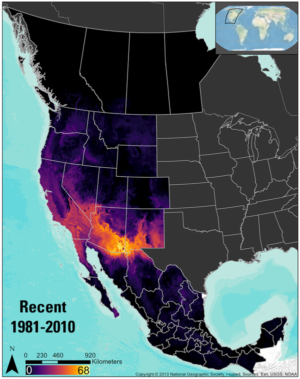
The climate-niche distribution--or the areas with suitable climate for survival--were mapped 130 reptile species in the recent time period and predicted for the late-century time period under the RCP 8.5 climate scenario. The RCP 8.5 scenario assumes carbon emissions continue at their current levels.
Michelle I Jeffries
I am an Ecologist at the USGS Forest and Rangeland Ecosystem Science Center.
I work on projects related to restoration ecology in sagebrush ecosystems and reptile distribution modeling across western North America.
Professional Experience
2016 - Present: Ecologist, USGS Forest and Rangeland Ecosystem Science Center, Boise, ID
2013 - 2016: Research Assistant, Department of Biological Sciences, Boise State University, Boise, ID
2012 - 2013: Biological Field Technician, USGS Forest and Rangeland Ecosystem Science Center, Boise, ID
Education and Certifications
M.S., Biology, Boise State University, Boise, ID (2016)
B.S., Biology, Ecology, Boise State University, Boise, ID (2013)
Science and Products
Project ROAM
Wildland Fire Trends Tool
GIS Clipping and Summarization Tool for Points, Lines, Polygons, and Rasters
The Wildfire Trends Tool: A data visualization and analysis tool to meet land management needs and facilitate scientific inquiry
Integrating short-term climate forecast into a restoration management support tool
Land Treatment Exploration Tool
If you are unable to access or download a product, email fresc_outreach@usgs.gov a request, including the full citation, or call (541) 750-1030.
Western North America terrestrial reptile climate-niche rasters and summary data
Sagebrush recovery projections across the biome, 30 years after two seeding treatment applications, and associated model data (1986-2021)
Reestablishing a foundational species: limitations on post-wildfire sagebrush seedling establishment
Combined wildland fire datasets for the United States and certain territories, 1800s-Present
USGS Land Treatment Digital Library Data Release: A centralized archive for land treatment tabular and spatial data (ver. 7.0, September 2024)
NRCS FY2018 Soil Properties and Interpretations, Derived Using gSSURGO Data and Tools
Combined wildfire datasets for the United States and certain territories, 1878-2019
Reptile Richness in the Range of the Sage-grouse, Derived From Species Range Maps
The Sagebrush Biome Range Extent, as Derived from Classified Landsat Imagery
Western United States 30m Raw Heatload Values
Western US Ruggedness Reclassified into 6 Classes
The climate-niche distribution--or the areas with suitable climate for survival--were mapped 130 reptile species in the recent time period and predicted for the late-century time period under the RCP 8.5 climate scenario. The RCP 8.5 scenario assumes carbon emissions continue at their current levels.
This is a quick introduction video to guide users through new features added to the Land Treatment Exploration Tool in 2022.
This is a quick introduction video to the Land Treatment Exploration Tool. This short video includes a summary of the tool with screen clips of the fact sheet, web tool, and an example Site Characterization Report.
This video describes Step 1 of the Land Treatment Exploration Tool. In Step 1 the user defines a name, the planned treatment/s, and a file name for exported items.
This video describes Step 2 of the Land Treatment Exploration Tool. In Step 2 the user defines their planned treatment boundary. The user can load a zipped shapefile or on-screen digitize their boundary.
This video describes Step 3 of the Land Treatment Exploration Tool. In Step 3 the user is guided to the Site History tab to explore land treatment and wildfire history of their planned treatment area.
This video describes Step 4 and the developing report of the Land Treatment Exploration Tool. In Step 4 the used selects layers to generate spatial overlap statistics with their planned treatment boundary. Summary tables are generated and displayed in the Report tab, where a user can create a PDF Site Characterization Report for their planned treatment boundary.
This video describes Step 5 of the Land Treatment Exploration Tool. In Step 5 the user determines a distance or boundary to search for legacy Land Treatment Digital Library records. The user also indicates if the returned LTDL treatments are statistically evaluated against the planned treatment boundary using a Bray-Curtis Dissimilarity calculation.
This video describes Step 6 of the Land Treatment Exploration Tool. In Step 6 the user filters through the returned list of legacy LTDL treatments to identify records that contain useful information or context for the current planned treatment boundary. Selected treatments are added to the developing report and subsequent exported Site Characterization PDFs.
If you are unable to access or download a product, email fresc_outreach@usgs.gov a request, including the full citation, or call (541) 750-1030.
Leveraging extensive soil, vegetation, fire, and land treatment data to inform restoration across the sagebrush biome
Closing the conservation gap in the sagebrush biome: Spatial targeting and coordination are needed for conservation to keep pace with sagebrush losses
Climate futures for lizards and snakes in western North America may result in new species management issues
Reestablishing a foundational species: limitations on post-wildfire sagebrush seedling establishment
Protecting restoration investments from the cheatgrass-fire cycle in sagebrush steppe
Reptiles under the conservation umbrella of the greater sage‐grouse
Land treatment exploration tool
If you are unable to access or download a product, email fresc_outreach@usgs.gov a request, including the full citation.
Amphibian and Reptile Species Distribution Explorer
Interactive Supplement - When and How Often do Seedings Experience a Wildfire?
Wildland Fire Trends Tool
Land Treatment Exploration Tool
Land Treatment Digital Library
If you are unable to access or download a product, email fresc_outreach@usgs.gov a request, including the full citation, or call (541) 750-1030.
GIS Clipping and Summarization Toolbox
Science and Products
Project ROAM
Wildland Fire Trends Tool
GIS Clipping and Summarization Tool for Points, Lines, Polygons, and Rasters
The Wildfire Trends Tool: A data visualization and analysis tool to meet land management needs and facilitate scientific inquiry
Integrating short-term climate forecast into a restoration management support tool
Land Treatment Exploration Tool
If you are unable to access or download a product, email fresc_outreach@usgs.gov a request, including the full citation, or call (541) 750-1030.
Western North America terrestrial reptile climate-niche rasters and summary data
Sagebrush recovery projections across the biome, 30 years after two seeding treatment applications, and associated model data (1986-2021)
Reestablishing a foundational species: limitations on post-wildfire sagebrush seedling establishment
Combined wildland fire datasets for the United States and certain territories, 1800s-Present
USGS Land Treatment Digital Library Data Release: A centralized archive for land treatment tabular and spatial data (ver. 7.0, September 2024)
NRCS FY2018 Soil Properties and Interpretations, Derived Using gSSURGO Data and Tools
Combined wildfire datasets for the United States and certain territories, 1878-2019
Reptile Richness in the Range of the Sage-grouse, Derived From Species Range Maps
The Sagebrush Biome Range Extent, as Derived from Classified Landsat Imagery
Western United States 30m Raw Heatload Values
Western US Ruggedness Reclassified into 6 Classes
The climate-niche distribution--or the areas with suitable climate for survival--were mapped 130 reptile species in the recent time period and predicted for the late-century time period under the RCP 8.5 climate scenario. The RCP 8.5 scenario assumes carbon emissions continue at their current levels.
This is a quick introduction video to guide users through new features added to the Land Treatment Exploration Tool in 2022.
This is a quick introduction video to the Land Treatment Exploration Tool. This short video includes a summary of the tool with screen clips of the fact sheet, web tool, and an example Site Characterization Report.
This video describes Step 1 of the Land Treatment Exploration Tool. In Step 1 the user defines a name, the planned treatment/s, and a file name for exported items.
This video describes Step 2 of the Land Treatment Exploration Tool. In Step 2 the user defines their planned treatment boundary. The user can load a zipped shapefile or on-screen digitize their boundary.
This video describes Step 3 of the Land Treatment Exploration Tool. In Step 3 the user is guided to the Site History tab to explore land treatment and wildfire history of their planned treatment area.
This video describes Step 4 and the developing report of the Land Treatment Exploration Tool. In Step 4 the used selects layers to generate spatial overlap statistics with their planned treatment boundary. Summary tables are generated and displayed in the Report tab, where a user can create a PDF Site Characterization Report for their planned treatment boundary.
This video describes Step 5 of the Land Treatment Exploration Tool. In Step 5 the user determines a distance or boundary to search for legacy Land Treatment Digital Library records. The user also indicates if the returned LTDL treatments are statistically evaluated against the planned treatment boundary using a Bray-Curtis Dissimilarity calculation.
This video describes Step 6 of the Land Treatment Exploration Tool. In Step 6 the user filters through the returned list of legacy LTDL treatments to identify records that contain useful information or context for the current planned treatment boundary. Selected treatments are added to the developing report and subsequent exported Site Characterization PDFs.
If you are unable to access or download a product, email fresc_outreach@usgs.gov a request, including the full citation, or call (541) 750-1030.
Leveraging extensive soil, vegetation, fire, and land treatment data to inform restoration across the sagebrush biome
Closing the conservation gap in the sagebrush biome: Spatial targeting and coordination are needed for conservation to keep pace with sagebrush losses
Climate futures for lizards and snakes in western North America may result in new species management issues
Reestablishing a foundational species: limitations on post-wildfire sagebrush seedling establishment
Protecting restoration investments from the cheatgrass-fire cycle in sagebrush steppe
Reptiles under the conservation umbrella of the greater sage‐grouse
Land treatment exploration tool
If you are unable to access or download a product, email fresc_outreach@usgs.gov a request, including the full citation.
Amphibian and Reptile Species Distribution Explorer
Interactive Supplement - When and How Often do Seedings Experience a Wildfire?
Wildland Fire Trends Tool
Land Treatment Exploration Tool
Land Treatment Digital Library
If you are unable to access or download a product, email fresc_outreach@usgs.gov a request, including the full citation, or call (541) 750-1030.