
Maddy Holland (New England Water Science Center), Eric White (Water Mission Area - Hydrologic Remote Sensing Branch), Jason Sorenson (New England Water Science Center), and Carole Johnson (Water Mission Area - Hydrologic Remote Sensing Branch) moving heavy TDEM field gear across a field in Edgartown, Massachusetts.
Timothy D McCobb
Tim McCobb is a Hydrologist in the USGS New England Water Science Center.
Tim has experience working on groundwater projects in southeastern Massachusetts, including research at the USGS Cape Cod Toxic Substances Hydrology field site and technical support of Dept. of Defense environmental restoration programs at Joint Base Cape Cod. He has extensive experience in groundwater field techniques, groundwater flow modeling, and GIS. Tim is currently working on projects that include the assessment of regional freshwater resources by using groundwater modeling, the examination of nitrogen and emerging contaminants in shallow, coastal groundwater, and the characterization of groundwater/surface-water interactions at a glacial kettle pond.
Science and Products

Effects of Sea-Level Rise and Climate Change on the Groundwater-Flow System of Martha’s Vineyard, Massachusetts
The U.S. Geological Survey (USGS), in cooperation with the Massachusetts Department of Environmental Protection (MassDEP), is investigating the effects of sea-level rise and climate change on the groundwater resources of Martha’s Vineyard, Massachusetts.

Assessment of Nutrient Transport and Discharge to Coastal Embayments, Wickford, Rhode Island
In 2020, the USGS began a partnership with the U.S. Environmental Protection Agency (EPA) Region 1 Southeast New England Program for Coastal Watershed Restoration (SNEP) and EPA Office of Research and Development (ORD), Atlantic Coastal Sciences Division, Narragansett, RI in support of water-quality and ecological monitoring being conducted by ORD in the coastal waters around Wickford, RI. The...

Measurement and Modeling of Nitrogen Discharge to Cape Cod Rivers to Identify High-Priority Nitrogen Reduction Areas
In 2019 USGS and the U.S. Environmental Protection Agency (EPA) Region 1 initiated a study to measure spatial and temporal patterns of nitrogen loading in selected rivers on Cape Cod and then determine whether the measured patterns can be related to nitrogen source areas in the surrounding watersheds to prioritize nitrogen reduction efforts. Study results will improve understanding of nitrogen...

Hydrologic Monitoring in the Three Bays Watershed in Support of Nutrient Management Activities, Cape Cod, Massachusetts
In 2019 the USGS began a partnership with the U.S. Environmental Protection Agency (EPA) Office of Research and Development (ORD), EPA Region 1 Southeast New England Program for Coastal Watershed Restoration (SNEP), Barnstable Clean Water Coalition (BCWC), and other stakeholders to conduct hydrologic monitoring and assessment in support of multifaceted nutrient-management activities in the Three...

Assessment of Potential Effects of Water-Supply Withdrawals on Groundwater Levels near the Hyannis Ponds Complex, Barnstable, Massachusetts
The USGS, in cooperation with the Town of Barnstable and MassWildlife, is assessing the potential effects of new water-supply withdrawals on groundwater levels in the Hyannis Ponds Wildlife Management Area on Cape Cod. A groundwater-flow model is being used to simulate the effects of several possible withdrawal and wastewater-return flow scenarios developed by the Town of Barnstable and...

Hydrologic Site Assessment for Passive Treatment of Groundwater Nitrogen with Permeable Reactive Barriers, Cape Cod, Massachusetts
In 2019 USGS completed a study designed to develop and evaluate a phased site-assessment approach for determining the hydrologic suitability of sites being considered for permeable reactive barrier installation on Cape Cod. The approach provides a template for town officials and other stakeholders to follow when considering PRBs for passive treatment of nitrogen in groundwater on Cape Cod and...

USGS Publications on the Water Resources of Cape Cod and Southeastern Massachusetts
The U.S. Geological Survey (USGS) has been investigating groundwater and surface-water resources on Cape Cod for more than 50 years. Recent studies have focused on the sources of water to public-supply wells, ponds, streams, and coastal areas; transport and discharge of nitrogen and contaminants of emerging concern derived from domestic and municipal wastewater disposal; fate and transport of...

Assessment of Hydrologic and Water-Quality Changes in Shallow Groundwater Beneath a Coastal Neighborhood Being Converted from Septic Systems to Municipal Sewers
The U.S. Geological Survey and the U.S. Environmental Protection Agency are collaborating on a study to better understand changes to groundwater quality beneath a densely developed coastal neighborhood as it undergoes conversion from onsite wastewater disposal to municipal sewering.

Geospatial Dataset of Wells and Attributes in the New England Groundwater Level Network, 2017
The drought of 2016 affected hydrologic conditions throughout New England. Responses of USGS groundwater observation wells to this event, however, were not uniform and were sometimes markedly different from site to site. Although USGS scientists were able to provide explanations for most of these situations, the event highlighted the need for additional well information to develop quantitative and...

Hydrologists with TDEM Equipment
Maddy Holland (New England Water Science Center), Eric White (Water Mission Area - Hydrologic Remote Sensing Branch), Jason Sorenson (New England Water Science Center), and Carole Johnson (Water Mission Area - Hydrologic Remote Sensing Branch) moving heavy TDEM field gear across a field in Edgartown, Massachusetts.

Hydrologist operates Time Domain Electromagnetic equipment on Martha's Vineyard
Hydrologist operates Time Domain Electromagnetic equipment on Martha's VineyardHydrologist of the Hydrologic Remote Sensing Branch of the USGS Water Mission Area, operates Time-domain electromagnetic (TDEM) equipment in Chilmark, Massachusetts.

Gay Head Lighthouse, Aquinnah, Massachusetts
Gay Head Lighthouse and Aquinnah Cliffs, Aquinnah, Martha's Vineyard, Massachusetts.
Gay Head Lighthouse and Aquinnah Cliffs, Aquinnah, Martha's Vineyard, Massachusetts.

Lighthouse in Edgartown, Massachusetts
Edgartown Lighthouse looking northwest toward Edgartown, Martha's Vineyard, Massachusetts.
Edgartown Lighthouse looking northwest toward Edgartown, Martha's Vineyard, Massachusetts.

American beachgrass planted near South Beach in Edgartown, Massachusetts
American beachgrass planted near South Beach in Edgartown, MassachusettsAmerican beachgrass planted near South Beach in Edgartown, MA (looking east) during sunrise.
American beachgrass planted near South Beach in Edgartown, Massachusetts
American beachgrass planted near South Beach in Edgartown, MassachusettsAmerican beachgrass planted near South Beach in Edgartown, MA (looking east) during sunrise.

South Beach, Edgartown, Massachusetts
South Beach looking west at sunset in Edgartown, Martha's Vineyard, Massachusetts.
South Beach looking west at sunset in Edgartown, Martha's Vineyard, Massachusetts.

Farmland in Chilmark, Massachusetts
Deer grazing in a hayfield during the evening on farmland in Chilmark, Massachusetts.
Deer grazing in a hayfield during the evening on farmland in Chilmark, Massachusetts.
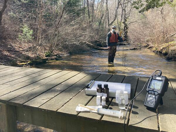
Measuring Streamflow and Water Quality Sampling in the Mashpee River
Measuring Streamflow and Water Quality Sampling in the Mashpee RiverHydrologic Technician Kyle Fronte measures streamflow in the Mashpee River and also takes water quality samples for a project that designed, tested, and evaluated approaches for using field observations and groundwater-flow simulations to identify areas of high nitrogen loading to selected rivers on Cape Cod.

Academy Cove, Wickford, Rhode Island
The USGS is conducting a study to characterize groundwater and surface water-quality to address the need for a better understanding of nutrient inputs to the coastal waters. The initial focus of the study is on local-scale hydrologic monitoring adjacent to Academy Cove.
The USGS is conducting a study to characterize groundwater and surface water-quality to address the need for a better understanding of nutrient inputs to the coastal waters. The initial focus of the study is on local-scale hydrologic monitoring adjacent to Academy Cove.

Streamgage 0110588340 Barnstable, MA
Streamgage location (0110588340) on the Santuit River at Old Kings Road, Barnstable MA.
Streamgage location (0110588340) on the Santuit River at Old Kings Road, Barnstable MA.

Drillers using a sonic drilling rig to install monitoring wells
Drillers using a sonic drilling rig to install monitoring wellsDrillers from the Environmental Protection Agency Office of Research and Development (Ada, OK) using a sonic drilling rig to install monitoring wells in Barnstable, Massachusetts.

Monitoring wells East Falmouth, MA
Monitoring wells located along the eastern shore of Little Pond, East Falmouth, Massachusetts.
Monitoring wells located along the eastern shore of Little Pond, East Falmouth, Massachusetts.

Groundwater sampling
Groundwater sampling along the eastern shore of Little Pond, East Falmouth, Massachusetts.
Groundwater sampling along the eastern shore of Little Pond, East Falmouth, Massachusetts.

Groundwater sampling
Groundwater sampling along the western shore of Great Pond, East Falmouth, Massachusetts.
Groundwater sampling along the western shore of Great Pond, East Falmouth, Massachusetts.

View of the eastern shore of Little Pond, East Falmouth, MA
View of the eastern shore of Little Pond, East Falmouth, MAEutrophication seen on the eastern shore of Little Pond, East Falmouth, Massachusetts.
View of the eastern shore of Little Pond, East Falmouth, MA
View of the eastern shore of Little Pond, East Falmouth, MAEutrophication seen on the eastern shore of Little Pond, East Falmouth, Massachusetts.

View along the eastern shore of Little Pond, East Falmouth
View along the eastern shore of Little Pond, East FalmouthEutrophication is seen along the eastern shore of Little Pond, East Falmouth, Massachusetts.
View along the eastern shore of Little Pond, East Falmouth
View along the eastern shore of Little Pond, East FalmouthEutrophication is seen along the eastern shore of Little Pond, East Falmouth, Massachusetts.

Well installation using a Geoprobe drilling rig
Well installation using a Geoprobe drilling rig in the Maravista neighborhood, East Falmouth, MA
Well installation using a Geoprobe drilling rig in the Maravista neighborhood, East Falmouth, MA
Science and Products
Effects of Sea-Level Rise and Climate Change on the Groundwater-Flow System of Martha’s Vineyard, Massachusetts
The U.S. Geological Survey (USGS), in cooperation with the Massachusetts Department of Environmental Protection (MassDEP), is investigating the effects of sea-level rise and climate change on the groundwater resources of Martha’s Vineyard, Massachusetts.
Assessment of Nutrient Transport and Discharge to Coastal Embayments, Wickford, Rhode Island
In 2020, the USGS began a partnership with the U.S. Environmental Protection Agency (EPA) Region 1 Southeast New England Program for Coastal Watershed Restoration (SNEP) and EPA Office of Research and Development (ORD), Atlantic Coastal Sciences Division, Narragansett, RI in support of water-quality and ecological monitoring being conducted by ORD in the coastal waters around Wickford, RI. The...
Measurement and Modeling of Nitrogen Discharge to Cape Cod Rivers to Identify High-Priority Nitrogen Reduction Areas
In 2019 USGS and the U.S. Environmental Protection Agency (EPA) Region 1 initiated a study to measure spatial and temporal patterns of nitrogen loading in selected rivers on Cape Cod and then determine whether the measured patterns can be related to nitrogen source areas in the surrounding watersheds to prioritize nitrogen reduction efforts. Study results will improve understanding of nitrogen...
Hydrologic Monitoring in the Three Bays Watershed in Support of Nutrient Management Activities, Cape Cod, Massachusetts
In 2019 the USGS began a partnership with the U.S. Environmental Protection Agency (EPA) Office of Research and Development (ORD), EPA Region 1 Southeast New England Program for Coastal Watershed Restoration (SNEP), Barnstable Clean Water Coalition (BCWC), and other stakeholders to conduct hydrologic monitoring and assessment in support of multifaceted nutrient-management activities in the Three...
Assessment of Potential Effects of Water-Supply Withdrawals on Groundwater Levels near the Hyannis Ponds Complex, Barnstable, Massachusetts
The USGS, in cooperation with the Town of Barnstable and MassWildlife, is assessing the potential effects of new water-supply withdrawals on groundwater levels in the Hyannis Ponds Wildlife Management Area on Cape Cod. A groundwater-flow model is being used to simulate the effects of several possible withdrawal and wastewater-return flow scenarios developed by the Town of Barnstable and...
Hydrologic Site Assessment for Passive Treatment of Groundwater Nitrogen with Permeable Reactive Barriers, Cape Cod, Massachusetts
In 2019 USGS completed a study designed to develop and evaluate a phased site-assessment approach for determining the hydrologic suitability of sites being considered for permeable reactive barrier installation on Cape Cod. The approach provides a template for town officials and other stakeholders to follow when considering PRBs for passive treatment of nitrogen in groundwater on Cape Cod and...
USGS Publications on the Water Resources of Cape Cod and Southeastern Massachusetts
The U.S. Geological Survey (USGS) has been investigating groundwater and surface-water resources on Cape Cod for more than 50 years. Recent studies have focused on the sources of water to public-supply wells, ponds, streams, and coastal areas; transport and discharge of nitrogen and contaminants of emerging concern derived from domestic and municipal wastewater disposal; fate and transport of...
Assessment of Hydrologic and Water-Quality Changes in Shallow Groundwater Beneath a Coastal Neighborhood Being Converted from Septic Systems to Municipal Sewers
The U.S. Geological Survey and the U.S. Environmental Protection Agency are collaborating on a study to better understand changes to groundwater quality beneath a densely developed coastal neighborhood as it undergoes conversion from onsite wastewater disposal to municipal sewering.
Geospatial Dataset of Wells and Attributes in the New England Groundwater Level Network, 2017
The drought of 2016 affected hydrologic conditions throughout New England. Responses of USGS groundwater observation wells to this event, however, were not uniform and were sometimes markedly different from site to site. Although USGS scientists were able to provide explanations for most of these situations, the event highlighted the need for additional well information to develop quantitative and...
Hydrologists with TDEM Equipment
Maddy Holland (New England Water Science Center), Eric White (Water Mission Area - Hydrologic Remote Sensing Branch), Jason Sorenson (New England Water Science Center), and Carole Johnson (Water Mission Area - Hydrologic Remote Sensing Branch) moving heavy TDEM field gear across a field in Edgartown, Massachusetts.
Maddy Holland (New England Water Science Center), Eric White (Water Mission Area - Hydrologic Remote Sensing Branch), Jason Sorenson (New England Water Science Center), and Carole Johnson (Water Mission Area - Hydrologic Remote Sensing Branch) moving heavy TDEM field gear across a field in Edgartown, Massachusetts.
Hydrologist operates Time Domain Electromagnetic equipment on Martha's Vineyard
Hydrologist operates Time Domain Electromagnetic equipment on Martha's VineyardHydrologist of the Hydrologic Remote Sensing Branch of the USGS Water Mission Area, operates Time-domain electromagnetic (TDEM) equipment in Chilmark, Massachusetts.
Gay Head Lighthouse, Aquinnah, Massachusetts
Gay Head Lighthouse and Aquinnah Cliffs, Aquinnah, Martha's Vineyard, Massachusetts.
Gay Head Lighthouse and Aquinnah Cliffs, Aquinnah, Martha's Vineyard, Massachusetts.
Lighthouse in Edgartown, Massachusetts
Edgartown Lighthouse looking northwest toward Edgartown, Martha's Vineyard, Massachusetts.
Edgartown Lighthouse looking northwest toward Edgartown, Martha's Vineyard, Massachusetts.
American beachgrass planted near South Beach in Edgartown, Massachusetts
American beachgrass planted near South Beach in Edgartown, MassachusettsAmerican beachgrass planted near South Beach in Edgartown, MA (looking east) during sunrise.
American beachgrass planted near South Beach in Edgartown, Massachusetts
American beachgrass planted near South Beach in Edgartown, MassachusettsAmerican beachgrass planted near South Beach in Edgartown, MA (looking east) during sunrise.
South Beach, Edgartown, Massachusetts
South Beach looking west at sunset in Edgartown, Martha's Vineyard, Massachusetts.
South Beach looking west at sunset in Edgartown, Martha's Vineyard, Massachusetts.
Farmland in Chilmark, Massachusetts
Deer grazing in a hayfield during the evening on farmland in Chilmark, Massachusetts.
Deer grazing in a hayfield during the evening on farmland in Chilmark, Massachusetts.
Measuring Streamflow and Water Quality Sampling in the Mashpee River
Measuring Streamflow and Water Quality Sampling in the Mashpee RiverHydrologic Technician Kyle Fronte measures streamflow in the Mashpee River and also takes water quality samples for a project that designed, tested, and evaluated approaches for using field observations and groundwater-flow simulations to identify areas of high nitrogen loading to selected rivers on Cape Cod.
Academy Cove, Wickford, Rhode Island
The USGS is conducting a study to characterize groundwater and surface water-quality to address the need for a better understanding of nutrient inputs to the coastal waters. The initial focus of the study is on local-scale hydrologic monitoring adjacent to Academy Cove.
The USGS is conducting a study to characterize groundwater and surface water-quality to address the need for a better understanding of nutrient inputs to the coastal waters. The initial focus of the study is on local-scale hydrologic monitoring adjacent to Academy Cove.
Streamgage 0110588340 Barnstable, MA
Streamgage location (0110588340) on the Santuit River at Old Kings Road, Barnstable MA.
Streamgage location (0110588340) on the Santuit River at Old Kings Road, Barnstable MA.
Drillers using a sonic drilling rig to install monitoring wells
Drillers using a sonic drilling rig to install monitoring wellsDrillers from the Environmental Protection Agency Office of Research and Development (Ada, OK) using a sonic drilling rig to install monitoring wells in Barnstable, Massachusetts.
Monitoring wells East Falmouth, MA
Monitoring wells located along the eastern shore of Little Pond, East Falmouth, Massachusetts.
Monitoring wells located along the eastern shore of Little Pond, East Falmouth, Massachusetts.
Groundwater sampling
Groundwater sampling along the eastern shore of Little Pond, East Falmouth, Massachusetts.
Groundwater sampling along the eastern shore of Little Pond, East Falmouth, Massachusetts.
Groundwater sampling
Groundwater sampling along the western shore of Great Pond, East Falmouth, Massachusetts.
Groundwater sampling along the western shore of Great Pond, East Falmouth, Massachusetts.
View of the eastern shore of Little Pond, East Falmouth, MA
View of the eastern shore of Little Pond, East Falmouth, MAEutrophication seen on the eastern shore of Little Pond, East Falmouth, Massachusetts.
View of the eastern shore of Little Pond, East Falmouth, MA
View of the eastern shore of Little Pond, East Falmouth, MAEutrophication seen on the eastern shore of Little Pond, East Falmouth, Massachusetts.
View along the eastern shore of Little Pond, East Falmouth
View along the eastern shore of Little Pond, East FalmouthEutrophication is seen along the eastern shore of Little Pond, East Falmouth, Massachusetts.
View along the eastern shore of Little Pond, East Falmouth
View along the eastern shore of Little Pond, East FalmouthEutrophication is seen along the eastern shore of Little Pond, East Falmouth, Massachusetts.
Well installation using a Geoprobe drilling rig
Well installation using a Geoprobe drilling rig in the Maravista neighborhood, East Falmouth, MA
Well installation using a Geoprobe drilling rig in the Maravista neighborhood, East Falmouth, MA