The Landsat Level-3 Dynamic Surface Water Extent (DSWE) Science Product provides information that represents surface water inundation as detected in cloud-, shadow-, and snow-free pixels, in six acquisition-based raster files.
Return to Landsat Science Products Overview
The Landsat DSWE product provides important information about the existence and condition of surface water.
The table below displays how different communities use Landsat DSWE products in their research.
Community | Potential use |
---|---|
Hydrologic science/ Water resource management | Hydrologic modeling (local to national scale), Large river discharge estimation, local level surface storage reservoir monitoring |
Biologic science/Resource management | Habitat assessment, minimum flow requirement analyses |
Wetland science/Resource management | Wetland delineation and monitoring |
Climate science/Change response | Energy balance and carbon cycling studies and modeling |
Emergency preparedness and response | Flood mitigation and recovery, aid distribution, insurance underwriting; drought monitoring |
Geospatial data providers | Land cover and cartographic data enhancement |
State and local government | Storm water best management practices, pond and reservoir monitoring |
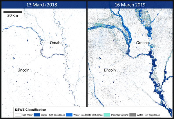
The images and animations below are examples of how Landsat DSWE data are used.
Related Content
Landsat Collection 2 Level-3 Dynamic Surface Water Extent science product
Comparing Landsat Dynamic Surface Water Extent to alternative methods of measuring inundation in developing waterbird habitats
Improved automated detection of subpixel-scale inundation – Revised Dynamic Surface Water Extent (DSWE) partial surface water tests
Efficient wetland surface water detection and monitoring via Landsat: Comparison with in situ data from the Everglades Depth Estimation Network
Landsat: Products and Services from the USGS
An interactive StoryMap presented during the USGS webinar 'Landsat: Products and Services from the USGS.'
Landsat Science Products Overview
Explore an overview of the Landsat Science Products.
Related Content
- Publications
Landsat Collection 2 Level-3 Dynamic Surface Water Extent science product
The Landsat Collection 2 Level-3 Dynamic Surface Water Extent science product provides raster data that represent surface water inundation per pixel in Landsat 4–9 imagery. The Collection 2 Dynamic Surface Water Extent science product contains six acquisition-based raster products relating to surface water. Surface water extent is modulated by weather and climate, stream network hydrology, and geoComparing Landsat Dynamic Surface Water Extent to alternative methods of measuring inundation in developing waterbird habitats
This study investigates the applicability of the Landsat Dynamic Surface Water Extent (DSWE) science product for waterbird habitat modeling in multiple non-canopied habitat types. We compare surface water distribution estimates derived from DSWE to two site-specific survey methods: visual surveys and digitized aerial imagery. These site-specific surveys were conducted on Poplar Island, a restoratiAuthorsJohn B. Taylor, Jeffery D. Sullivan, Claire S. Teitelbaum, Jan G. Reese, Diann ProsserImproved automated detection of subpixel-scale inundation – Revised Dynamic Surface Water Extent (DSWE) partial surface water tests
In order to produce useful hydrologic and aquatic habitat data from the Landsat system, the U.S. Geological Survey has developed the “Dynamic Surface Water Extent” (DSWE) Landsat Science Product. DSWE will provide long-term, high-temporal resolution data on variations in inundation extent. The model used to generate DSWE is composed of five decision-rule based tests that do not require scene-basedAuthorsJohn JonesEfficient wetland surface water detection and monitoring via Landsat: Comparison with in situ data from the Everglades Depth Estimation Network
The U.S. Geological Survey is developing new Landsat science products. One, named Dynamic Surface Water Extent (DSWE), is focused on the representation of ground surface inundation as detected in cloud-/shadow-/snow-free pixels for scenes collected over the U.S. and its territories. Characterization of DSWE uncertainty to facilitate its appropriate use in science and resource management is a primaAuthorsJohn Jones - Web Tools
Landsat: Products and Services from the USGS
An interactive StoryMap presented during the USGS webinar 'Landsat: Products and Services from the USGS.'
Landsat Science Products Overview
Explore an overview of the Landsat Science Products.