
Three neotropical birds (Left to right: Magnolia warbler, Wilson's warbler, Canada warbler - all males) that were cought in mist net for banding
Images
See our science through the images below.
Filter Total Items: 3532

three neotropical birds
Three neotropical birds (Left to right: Magnolia warbler, Wilson's warbler, Canada warbler - all males) that were cought in mist net for banding

Corals and mangroves share clear waters
Sediment can smother corals, but Hurricane Hole has no sediment-bearing freshwater streams. Its clear waters are habitat for an entire community of marine life, including Montastrea corals and squirrelfish. Photo: Caroline Rogers, USGS, 2009
Sediment can smother corals, but Hurricane Hole has no sediment-bearing freshwater streams. Its clear waters are habitat for an entire community of marine life, including Montastrea corals and squirrelfish. Photo: Caroline Rogers, USGS, 2009

Laboratory approaches for quantifying microbial process rates and analyte concentrations
Laboratory approaches for quantifying microbial process rates and analyte concentrationsLeft: Distillation rig used in the measurement of microbial sulfate reduction rates associated with a method based on the incubation of sediment samples with radioactively labeled sulfate. Photographer: M. Marvin-DiPasquale. Date: 3/5/2001.
Mobile Tracking in The Dalles on the Columbia River
Mobile Tracking in The Dalles on the Columbia RiverTracking/monitoring movement of juvenile salmonids implanted with radio transmitters as they migrate down the Columbia River to the ocean.
Mobile Tracking in The Dalles on the Columbia River
Mobile Tracking in The Dalles on the Columbia RiverTracking/monitoring movement of juvenile salmonids implanted with radio transmitters as they migrate down the Columbia River to the ocean.

Columbia River Contaminants and Habitat Study
USGS scientists strategize near the Rooster Rock boat launch en route to Skamania Landing to collect fish for the Columbia River Contaminants and Habitat Study.
People pictured from the left: Glen Holmberg, Leticia Torres, Conrad Frost, Elena Nilsen.
USGS scientists strategize near the Rooster Rock boat launch en route to Skamania Landing to collect fish for the Columbia River Contaminants and Habitat Study.
People pictured from the left: Glen Holmberg, Leticia Torres, Conrad Frost, Elena Nilsen.

Late Fall on the Little Missouri River
Late fall in the North Dakota Badlands on the Little Missouri River near Medora.
Late fall in the North Dakota Badlands on the Little Missouri River near Medora.

Using Airboats For Marsh Studies
National Wetlands Research Center scientists use air boats for the marsh studies along the Gulf of Mexico.
National Wetlands Research Center scientists use air boats for the marsh studies along the Gulf of Mexico.

Beach on the Colorado River in Grand Canyon
Beaches in the rough terrain of Grand Canyon are a valued resource by hikers and river runners because they are fairly flat and vegetation free.
Beaches in the rough terrain of Grand Canyon are a valued resource by hikers and river runners because they are fairly flat and vegetation free.
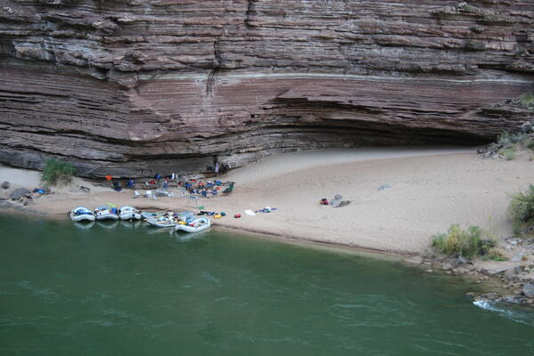
Large campsite area on the Colorado River in Grand Canyon
Large campsite area on the Colorado River in Grand CanyonBoats at a large campsite area along the Colorado River in Grand Canyon, 2009. USGS photo, public domain.
Large campsite area on the Colorado River in Grand Canyon
Large campsite area on the Colorado River in Grand CanyonBoats at a large campsite area along the Colorado River in Grand Canyon, 2009. USGS photo, public domain.

Ghost Crab
Ghost crab on the beach.

Queen angelfish - Hurricane Hole, Virgin Islands
A queen angelfish peers through the safety of the mangrove roots across the rich colors and textures of corals, sponges, urchins, and algae. Queen angelfish feed almost exclusively on sponges, which are abundant in these mangroves.
A queen angelfish peers through the safety of the mangrove roots across the rich colors and textures of corals, sponges, urchins, and algae. Queen angelfish feed almost exclusively on sponges, which are abundant in these mangroves.

Invasive Lionfish Removal
In September 2009, divers carefully capture an invasive red lionfish (Pterois volitans) found near the coast of North Carolina. Invasive lionfish are now established in the hard bottom habitats of North Carolina's coast, where they are abundant.
In September 2009, divers carefully capture an invasive red lionfish (Pterois volitans) found near the coast of North Carolina. Invasive lionfish are now established in the hard bottom habitats of North Carolina's coast, where they are abundant.

Invasive Lionfish Removal
Research divers rest at 20 feet as they ascend with a dive bag containing invasive red lionfish (Pterois volitans). The bag is clipped to a line to prevent them being stung by the lionfish as its bladder fills with air during the ascent. These lionfish were removed from hard bottom habitat, about 100 foot deep, near the coast of North Carolina.
Research divers rest at 20 feet as they ascend with a dive bag containing invasive red lionfish (Pterois volitans). The bag is clipped to a line to prevent them being stung by the lionfish as its bladder fills with air during the ascent. These lionfish were removed from hard bottom habitat, about 100 foot deep, near the coast of North Carolina.

Unidentified Hawk
Unidentified hawk perched upon a dead tree.
Unidentified hawk perched upon a dead tree.

Coniferous Mountain Forest
Coniferous forest growing along side of a mountain.
Coniferous forest growing along side of a mountain.

Unidentified Conifers Near Pond
Unidentified coniferous trees growing near pond.
Unidentified coniferous trees growing near pond.

Unidentified Hawk
Unidentified hawk perched upon a dead tree.
Unidentified hawk perched upon a dead tree.

Unidentified Spruce (Picea Sp.)
A coniferous forest in a mountainous environment.
A coniferous forest in a mountainous environment.

Mountain Rainbow
Rainbow near a mountain and forest.
Rainbow near a mountain and forest.

Unidentified Conifers Near Pond
Unidentified coniferous trees growing near pond.
Unidentified coniferous trees growing near pond.

Unidentified Hawk
Unidentified hawk perched upon a dead tree.
Unidentified hawk perched upon a dead tree.