
Helicopter conducting low-level flights. Image courtesy Sander Geophysics Ltd.
Images
Energy and Minerals Mission Area images.
Filter Total Items: 538

Low-level flight helicopter with stinger
Helicopter conducting low-level flights. Image courtesy Sander Geophysics Ltd.

Pennington Mountain Critical Minerals
Geologists in the field at Pennington Mountain. The orange instrument is a portable gamma spectrometer. University of Maine-Presque Isle professor Chunzeng Wang (the lead author) is in front, Preston Bass is carrying the meter.
Geologists in the field at Pennington Mountain. The orange instrument is a portable gamma spectrometer. University of Maine-Presque Isle professor Chunzeng Wang (the lead author) is in front, Preston Bass is carrying the meter.

Mountain Pass mine in California
Open pit rare earth element mine at Mountain Pass, California. Stepped sides of the pit and access for mining vehicles are shown.
Open pit rare earth element mine at Mountain Pass, California. Stepped sides of the pit and access for mining vehicles are shown.
Mountain Pass REE mine in California
Open pit rare earth element mine at Mountain Pass, California. Stepped sides of the pit and access for mining vehicles are shown.
Open pit rare earth element mine at Mountain Pass, California. Stepped sides of the pit and access for mining vehicles are shown.

Airborne Geophysical Survey Helicopter with Cow
A helicopter rigged with an airborne geophysical survey collecting equipment. Information collected during these surveys can help with studying critical mineral resources, natural hazards and groundwater potential. A cow is here too.
A helicopter rigged with an airborne geophysical survey collecting equipment. Information collected during these surveys can help with studying critical mineral resources, natural hazards and groundwater potential. A cow is here too.

Airborne Geophysical Survey Helicopter in Nevada
A low-flying helicopter towing a geophysical device collects scientific data on groundwater and geology. Information collected during these surveys can help with studying critical mineral resources, natural hazards and groundwater potential.
A low-flying helicopter towing a geophysical device collects scientific data on groundwater and geology. Information collected during these surveys can help with studying critical mineral resources, natural hazards and groundwater potential.
EDMAP students conducting geologic mapping field work
EDMAP students conducting geologic mapping field workPhoto of several students conducting geologic mapping field work as part of an EDMAP student project.
EDMAP students conducting geologic mapping field work
EDMAP students conducting geologic mapping field workPhoto of several students conducting geologic mapping field work as part of an EDMAP student project.

Alisha Ellis in the marsh
Geologist Alisha Ellis kneels in the marsh grass while collecting sediment samples in Mississippi.
Geologist Alisha Ellis kneels in the marsh grass while collecting sediment samples in Mississippi.

Critical Minerals in Landsat 9
Landsat 9 is the latest in a prestigious line of satellites that have been watching our planet for nearly 50 years. They have monitored changes on land and made that information freely available to users around the world.
Landsat 9 is the latest in a prestigious line of satellites that have been watching our planet for nearly 50 years. They have monitored changes on land and made that information freely available to users around the world.

Evidence of previous exploration
A geologist, George Case, stands in front of an adit, an entrance to an underground mine, in the Graphite Creek Deposit on the Seward Peninsula, Alaska.
A geologist, George Case, stands in front of an adit, an entrance to an underground mine, in the Graphite Creek Deposit on the Seward Peninsula, Alaska.

Navigating a slippery slope at Graphite Creek Deposit
Navigating a slippery slope at Graphite Creek DepositGeologist, Sue Karl, at Graphite Creek Deposit on the Seward Peninsula, Alaska. She is making field observations and measurements about the flake graphite deposit and the surrounding host rocks. These observations were used in developing a model of flake graphite genesis. Graphite is a critical mineral which the US depends entirely on imports.

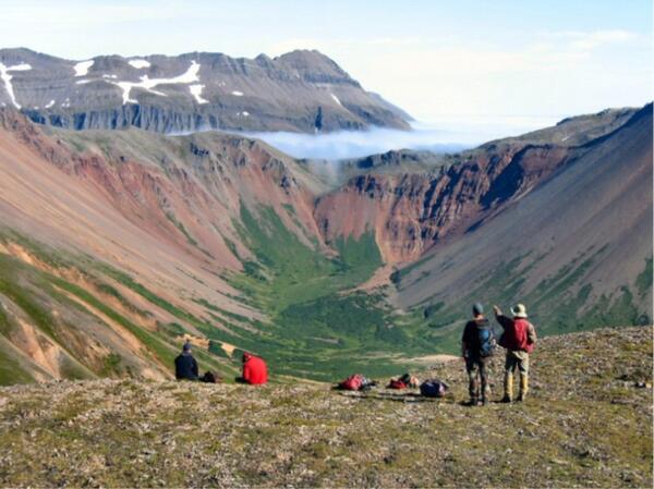
A Seward Peninsula Vista
Scenic view of the Seward Peninsula, Alaska. Photo taken from a ridge above Graphite Creek, looking northwest towards the Imruk Basin. This area of the Seward Peninsula holds the largest graphite deposit in the US known as the Graphite Creek Deposit.
Scenic view of the Seward Peninsula, Alaska. Photo taken from a ridge above Graphite Creek, looking northwest towards the Imruk Basin. This area of the Seward Peninsula holds the largest graphite deposit in the US known as the Graphite Creek Deposit.

Kigluaik Mountains Gneiss Dome
View of the Kigluaik Mountains gneiss dome which is the location of the Graphite Creek Deposit. The rocks of the gneiss dome were metamorphosed to as high as granulite facies during the middle Cretaceous (ca. 100 – 90 Ma), forming flake graphite ore in the process.
View of the Kigluaik Mountains gneiss dome which is the location of the Graphite Creek Deposit. The rocks of the gneiss dome were metamorphosed to as high as granulite facies during the middle Cretaceous (ca. 100 – 90 Ma), forming flake graphite ore in the process.

Mineral Commodity Summary February 2021
The 26th annual Mineral Commodity Summaries report from the U.S. Geological Survey National Minerals Information Center is the earliest comprehensive source of 2020 mineral production data for the world.
The 26th annual Mineral Commodity Summaries report from the U.S. Geological Survey National Minerals Information Center is the earliest comprehensive source of 2020 mineral production data for the world.

US Minerals Net Import Reliance in 2020
The United States continues to rely on foreign sources for some raw and processed mineral materials, including some critical minerals. This map shows the countries that supply mineral commodities for which the United States was more than 50% net import reliant in 2020.
The United States continues to rely on foreign sources for some raw and processed mineral materials, including some critical minerals. This map shows the countries that supply mineral commodities for which the United States was more than 50% net import reliant in 2020.

Western North Slope Foothills
The Kukpowruk River cuts through folded Cretaceous rocks in the central North Slope. These rocks were assessed by the USGS in 2017 and lie above the rocks assessed in the USGS 2021 Western North Slope assessment.
The Kukpowruk River cuts through folded Cretaceous rocks in the central North Slope. These rocks were assessed by the USGS in 2017 and lie above the rocks assessed in the USGS 2021 Western North Slope assessment.

Tingmerkpuk Ridges
Jurassic rocks exposed in thurst-faulted structures near the southern limit of Western North Slope. In the subsurface farther north, these rocks may be reservoir rocks for natural gas.
Jurassic rocks exposed in thurst-faulted structures near the southern limit of Western North Slope. In the subsurface farther north, these rocks may be reservoir rocks for natural gas.

Western North Slope Foothills
Geologist hikes across folded Cretaceous rocks in the central North Slope. These rocks were assessed by the USGS in 2017 and lie above the rocks assessed in the USGS 2021 Western North Slope assessment.
Geologist hikes across folded Cretaceous rocks in the central North Slope. These rocks were assessed by the USGS in 2017 and lie above the rocks assessed in the USGS 2021 Western North Slope assessment.

forest tower at the Alaska Peatland Experiment
A forest tower after a storm at the Alaska Peatland Experiment, a permafrost thaw research site. The tower helps researchers understand the ecosystem’s carbon balance.
A forest tower after a storm at the Alaska Peatland Experiment, a permafrost thaw research site. The tower helps researchers understand the ecosystem’s carbon balance.
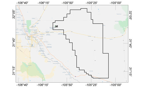
Flight area for Trans-Pecos aeromagnetic and radiometric survey
Flight area for Trans-Pecos aeromagnetic and radiometric surveyMap indicating flight area for Trans-Pecos aeromagnetic and radiometric survey. The survey area includes parts of El Paso and Hudspeth counties, Texas, and Otero County, New Mexico. Flights will begin in November 2020 and are expected to conclude in mid-January 2021.

USGS Technicians Prepare to Take a Core of the Austin Chalk in Texas
USGS Technicians Prepare to Take a Core of the Austin Chalk in TexasUSGS technicians at the USGS Gulf Coast #4 Bonham borehole in preparation for geophysical logging of the Austin Chalk Group and the Eagle Ford Group mudstones, Fannin County, Texas.