U.S. flag

An official website of the United States government

Images

Images related to natural hazards.

Filter Total Items: 7275
Deposit of the largest lahar from Mount Baker, Washington, exposed ...
Deposit of the largest lahar from Mount Baker, WA, exposed near con...

Note the protruding logs and branches from living trees that were knocked down and carried by the lahar. Ice axe, 3 ft, shows scale. Lahars are the greatest hazard at Mount Baker.

Timeline for eruptions at Mount Baker during the Holocene (12,000 y...
Timeline for eruptions at Mount Baker during Holocene
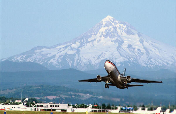
Airplane taking off with snow covered volcano in the background.
Mount Hood lies approximately 70 km (45 mi) from Portland International Airport. Volcanic Ash from eruptions can damage aircraft engines.
Graphic depicting the distribution of Yellowstone ash across the U....
Map of volcanic ash fall as a result of eruptions from Yellowstone,...

Map of volcanic ashfall. Areas of the United States that once were covered by volcanic ash from Yellowstone's giant eruptions 2 million and 630,000 years ago, compared with ashfall from the 760,000-year-old Long Valley caldera eruptions at Mammoth Lakes, California, and the 1980 eruption of Mount St. Helens, Washington.

Map of volcanic ashfall. Areas of the United States that once were covered by volcanic ash from Yellowstone's giant eruptions 2 million and 630,000 years ago, compared with ashfall from the 760,000-year-old Long Valley caldera eruptions at Mammoth Lakes, California, and the 1980 eruption of Mount St. Helens, Washington.

Craters of the Moon, Idaho, Landsat 7 true-color image viewed from ...

Craters of the Moon, Idaho, Landsat 7 true-color image viewed from the east. Pioneer Mountain Range along the western border. Image created by NASA EArth Observatory.

Image: Flooded marsh
Flooded marsh
Flooded marsh
Flooded marsh

Flooded marshes of Water Conservation Area 3 (WCA-3), seen north of I-75
(Alligator Alley).

Flooded marshes of Water Conservation Area 3 (WCA-3), seen north of I-75
(Alligator Alley).

Image: Flooded marsh
Flooded marsh
Flooded marsh
Flooded marsh

The marsh of Water Conservation Area 3 as seen looking north of I-75
(Alligator Alley). Spatterdock are seen in the foreground.

The marsh of Water Conservation Area 3 as seen looking north of I-75
(Alligator Alley). Spatterdock are seen in the foreground.

Cartoon depicting an earthquake along a subduction zone with big starburst symbol, shows how ocean water is displaced upward.
Earthquake starts tsunami

An earthquake along a subduction zone happens when the leading edge of the overriding plate breaks free and springs seaward, raising the sea floor and the water above it. This uplift starts a tsunami. Meanwhile, the bulge behind the leading edge collapses, thinning the plate and lowering coastal areas.

An earthquake along a subduction zone happens when the leading edge of the overriding plate breaks free and springs seaward, raising the sea floor and the water above it. This uplift starts a tsunami. Meanwhile, the bulge behind the leading edge collapses, thinning the plate and lowering coastal areas.

Cutaway views showing the internal structure of the Earth. Left: To...

Cutaway views showing the internal structure of the Earth. Left: To scale drawing shows that Earth's crust is very thin. Right: Not to scale, more detail of three main layers (crust, mantle, core).

Cutaway views showing the internal structure of the Earth. Left: To scale drawing shows that Earth's crust is very thin. Right: Not to scale, more detail of three main layers (crust, mantle, core).

Aerial view of Assateague Island

Aerial view of Assateague Island, looking north. Ocean City, Maryland, is visible in the far distance at top. Sinepuxent Bay lies between the island’s western shore and the Delmarva Peninsula to the upper left. Photograph taken in 1998 

Aerial view of Assateague Island, looking north. Ocean City, Maryland, is visible in the far distance at top. Sinepuxent Bay lies between the island’s western shore and the Delmarva Peninsula to the upper left. Photograph taken in 1998 

Poster with illustrations of the underwater part of a bay, with text about the work done in the area.
Mapping Shipping Hazards in San Francisco Bay, 1997-1998

Large-scale poster describing USGS work.

The USGS mapped western San Francisco Bay using sonar, in cooperation with the National Oceanic and Atmospheric Administration (NOAA) and C&C Technologies. Some parts of the Bay floor are so shallow that a large tanker or container ship could run aground at low tide and create a massive oil spill.

Large-scale poster describing USGS work.

The USGS mapped western San Francisco Bay using sonar, in cooperation with the National Oceanic and Atmospheric Administration (NOAA) and C&C Technologies. Some parts of the Bay floor are so shallow that a large tanker or container ship could run aground at low tide and create a massive oil spill.

Landslide came across a road in Seattle, into a house on the side of a cliff
Seattle Area Monitoring site

Photograph showing a house that was damaged by a 1997 landslide along Perkins Lane in Seattle, Washington.

Photograph showing a house that was damaged by a 1997 landslide along Perkins Lane in Seattle, Washington.

Profile of Mauna Kea showing inferred contact (dot-dashed line) bet...

Profile of Mauna Kea showing inferred contact (dot-dashed line) between postshield-stage Hamakua Volcanics and underlying shield-stage lavas. Approximate contact with Laupahoehoe Volcanics dashed.

Vog conditions on the Island of Hawai‘i vary depending on wind dire...
Vog conditions on the Island of Hawai‘i vary depending on wind direction

During prevailing trade wind conditions, the nearly constant stream of volcanic smog (vog) produced by Kīlauea Volcano on the Island of Hawai‘i is blown to the southwest and west. The trade winds (blue arrows) blow the vog from its main source on the volcano (white plume) to the southwest, where wind patterns send it up the island's Kona coast.

During prevailing trade wind conditions, the nearly constant stream of volcanic smog (vog) produced by Kīlauea Volcano on the Island of Hawai‘i is blown to the southwest and west. The trade winds (blue arrows) blow the vog from its main source on the volcano (white plume) to the southwest, where wind patterns send it up the island's Kona coast.

Color photo of 1997 hail damage to EROS ceiling windows
1997 Hail Damage Atrium Ceiling Windows

The July 1997 hail storm damaged many parts of the Mundt Building, including the recently installed atrium ceiling. EROS History Project

Volcanic gases react with the atmosphere in various ways

Volcanic gases react with the atmosphere in various ways; the conversion of sulfur dioxide (SO2) to sulfuric acid (H2SO4) has the most significant impact on climate.

Volcanic gases react with the atmosphere in various ways; the conversion of sulfur dioxide (SO2) to sulfuric acid (H2SO4) has the most significant impact on climate.

Geologic map of Mauna Kea, showing generalized distribution of lava...

Geologic map of Mauna Kea, showing generalized distribution of lava flows, cinder cones, and glacial deposits of the Laupahoehoe Volcanics.

landslide on the side of a cliff with a house at the top of the cliff, looking up at the house
Seattle Area Monitoring site

Photograph showing the scar left by a landslide on a hillside above the Burlington Northern Santa Fe Railway in Everett, Washington.

Photograph showing the scar left by a landslide on a hillside above the Burlington Northern Santa Fe Railway in Everett, Washington.

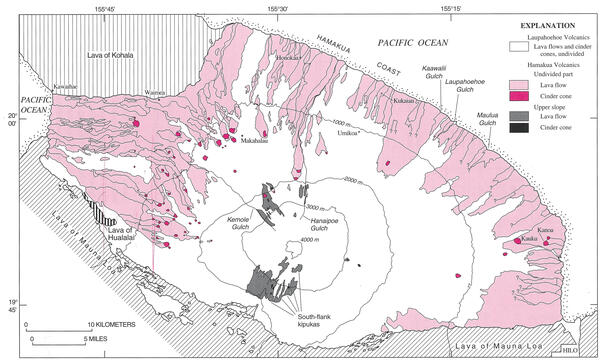
Geologic map of Mauna Kea with generalized surface distribution of ...

Geologic map of Mauna Kea with generalized surface distribution of Hamakua Volcanics. Laupahoehoe Volcanics are inferred to overlie a vast area of Hamakua Volcanics on the upper flanks and summit.

Was this page helpful?