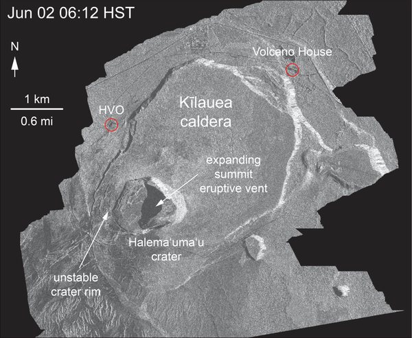
U.S. flag

An official website of the United States government

Images

Images related to natural hazards.

Filter Total Items: 7268
Kīlauea lower East Rift Zone lava flows and fissures, June 4, 2:00 ...
Kīlauea LERZ lava flows and fissures, June 4, 2:00 p.m.

Map as of 2:00 p.m. HST, June 4, 2018. Given the dynamic nature of Kīlauea's lower East Rift Zone eruption, with changing vent locations, fissures starting and stopping, and varying rates of lava effusion, map details shown here are accurate as of the date/time noted. Shaded purple areas indicate lava flows erupted in 1840, 1955, 1960, and 2014-2015.

Map as of 2:00 p.m. HST, June 4, 2018. Given the dynamic nature of Kīlauea's lower East Rift Zone eruption, with changing vent locations, fissures starting and stopping, and varying rates of lava effusion, map details shown here are accurate as of the date/time noted. Shaded purple areas indicate lava flows erupted in 1840, 1955, 1960, and 2014-2015.

Steamboat Geyser in the water-phase of an eruption on June 4, 2018,...
Steamboat Geyser in the water-phase of an eruption, Jun 4, 2019

Steamboat Geyser in the water-phase of an eruption on June 4, 2018, Norris Geyser Basin, Yellowstone National Park.

Steamboat Geyser in the steam-phase of an eruption on June 4, 2018,...
Steamboat Geyser in the steam-phase of an eruption, Jun 4, 2019

Steamboat Geyser in the steam-phase of an eruption on June 4, 2018, Norris Geyser Basin, Yellowstone National Park.

Ocean entry at Kapoho Bay
Kīlauea Volcano — Kapoho Bay Ocean Entry

Video from helicopter overflight of Kīlauea Volcano's lower East Rift Zone on June 4, 2018, shows lava from fissure 8 entering the ocean at Kapoho Bay. View to the north.

Video from helicopter overflight of Kīlauea Volcano's lower East Rift Zone on June 4, 2018, shows lava from fissure 8 entering the ocean at Kapoho Bay. View to the north.

Thermal map of fissure system and lava flows...
Thermal map of fissure system and lava flows

This thermal map shows the fissure system and lava flows as of 12:30 pm on Sunday, June 3. The flow from Fissure 8 continues to advance and had a wide flow front advancing towards the ocean in Kapoho. The black and white area is the extent of the thermal map.

This thermal map shows the fissure system and lava flows as of 12:30 pm on Sunday, June 3. The flow from Fissure 8 continues to advance and had a wide flow front advancing towards the ocean in Kapoho. The black and white area is the extent of the thermal map.

side by side of thermal images
Kīlauea Volcano — Fissure 8 Thermal Images

What a difference four days makes! These thermal images of fissure 8 fountains erupting on Kīlauea's lower East Rift Zone show a few things: 1) The lava fountains have gained height—with the tallest one growing from 150 ft to over 250 ft. 2) A pu‘u (cone) has built up downwind. 3) The amount of material wafting downwind is greater.

What a difference four days makes! These thermal images of fissure 8 fountains erupting on Kīlauea's lower East Rift Zone show a few things: 1) The lava fountains have gained height—with the tallest one growing from 150 ft to over 250 ft. 2) A pu‘u (cone) has built up downwind. 3) The amount of material wafting downwind is greater.

Thermal map of fissure system and lava flows...
Thermal map of fissure system and lava flows

This thermal map shows the fissure system and lava flows as of 12:30 pm on Monday, June 4 The flow from Fissure 8 remains active, with the flow front entering the ocean in Kapoho Bay over the past day. The black and white area is the extent of the thermal map.

This thermal map shows the fissure system and lava flows as of 12:30 pm on Monday, June 4 The flow from Fissure 8 remains active, with the flow front entering the ocean in Kapoho Bay over the past day. The black and white area is the extent of the thermal map.

 Displays showing the multibeam-sonar data acquisition and the navigation system
Multibeam-sonar data acquisition

Displays showing themultibeam-sonar data acquisition and the navigation system aboard the R/V Petrel during the geophysical survey in May 2018.

Displays showing themultibeam-sonar data acquisition and the navigation system aboard the R/V Petrel during the geophysical survey in May 2018.

Lava flow advancing
Kīlauea Volcano — Advancing Lava Flow

Overflight photo at 7AM HST from offshore looking up the flowfront. Nearly all of the front was active and advancing/spreading.

Animated GIF showing change in crater over several days
Kīlauea Volcano — Halema‘uma‘u Crater Slumping Animation

This animated GIF shows a sequence of radar amplitude images that were acquired by the Italian Space Agency's Cosmo-SkyMed satellite system. The images illustrate changes to the caldera area of Kīlauea Volcano that occurred between May 5 and June 2 at 6:00 p.m. HST.

This animated GIF shows a sequence of radar amplitude images that were acquired by the Italian Space Agency's Cosmo-SkyMed satellite system. The images illustrate changes to the caldera area of Kīlauea Volcano that occurred between May 5 and June 2 at 6:00 p.m. HST.

Plume rising from a crater
Kīlauea Volcano — Summit Plume

Summit plume at 8:40AM HST on June 3. A slight mist in the air softens the look of the plume, which is predominantly white steam with very minor amounts of ash.

Summit plume at 8:40AM HST on June 3. A slight mist in the air softens the look of the plume, which is predominantly white steam with very minor amounts of ash.

Lava flow advancing, ocean in foreground
Kīlauea Volcano — Advancing Flow

Photo from 7AM helicopter overflight, hovering offshore and looking up the flowfront. Nearly all of the front was active and advancing; advance rates were estimated at an average of 250 feet/hour (76 m/hr), and as of 7AM the flow was 500 yards (457 m) from the ocean.

Photo from 7AM helicopter overflight, hovering offshore and looking up the flowfront. Nearly all of the front was active and advancing; advance rates were estimated at an average of 250 feet/hour (76 m/hr), and as of 7AM the flow was 500 yards (457 m) from the ocean.

Thermal map of fissure system and lava flows...
Thermal map of fissure system and lava flows

This thermal map shows the fissure system and lava flows as of 5:30 pm on Friday, June 1. The flow from Fissure 8 continues to advance in a northeast direction and the front was roughly 9.5 km (5.9 miles) from the vent at Fissure 8. The black and white area is the extent of the thermal map.

This thermal map shows the fissure system and lava flows as of 5:30 pm on Friday, June 1. The flow from Fissure 8 continues to advance in a northeast direction and the front was roughly 9.5 km (5.9 miles) from the vent at Fissure 8. The black and white area is the extent of the thermal map.

Thermal map of fissure system and lava flows...
Thermal map of fissure system and lava flows

This thermal map shows the fissure system and lava flows as of 6:45 am on Saturday, June 2. The flow from Fissure 8 continues to advance in a northeast direction and the front was roughly 10.1 km (6.3 miles) from the vent at Fissure 8. The black and white area is the extent of the thermal map.

This thermal map shows the fissure system and lava flows as of 6:45 am on Saturday, June 2. The flow from Fissure 8 continues to advance in a northeast direction and the front was roughly 10.1 km (6.3 miles) from the vent at Fissure 8. The black and white area is the extent of the thermal map.

Slumping of west rim of Halema‘uma‘u...
Slumping of west rim of Halema‘uma‘u

This animated GIF shows a sequence of radar amplitude images that were acquired by the Italian Space Agency's Cosmo-SkyMed satellite system. The images illustrate changes to the caldera area of Kīlauea Volcano that occurred between May 5 and June 2 at 6:00 p.m. HST.

This animated GIF shows a sequence of radar amplitude images that were acquired by the Italian Space Agency's Cosmo-SkyMed satellite system. The images illustrate changes to the caldera area of Kīlauea Volcano that occurred between May 5 and June 2 at 6:00 p.m. HST.

Kīlauea lower East Rift Zone lava flows and fissures, June 3, 11:00...
Kīlauea LERZ lava flows and fissures, June 3, 11:00 a.m.

Map as of 11:00 a.m. HST, June 3, 2018. Given the dynamic nature of Kīlauea's lower East Rift Zone eruption, with changing vent locations, fissures starting and stopping, and varying rates of lava effusion, map details shown here are accurate as of the date/time noted. Shaded purple areas indicate lava flows erupted in 1840, 1955, 1960, and 2014-2015.

Map as of 11:00 a.m. HST, June 3, 2018. Given the dynamic nature of Kīlauea's lower East Rift Zone eruption, with changing vent locations, fissures starting and stopping, and varying rates of lava effusion, map details shown here are accurate as of the date/time noted. Shaded purple areas indicate lava flows erupted in 1840, 1955, 1960, and 2014-2015.

Map showing the location of active thermal areas

Large hydrothermal explosion craters shown with black dot and leader plus associated breccia deposits in Yellowstone National Park (locations from

Large hydrothermal explosion craters shown with black dot and leader plus associated breccia deposits in Yellowstone National Park (locations from

Lava flowing
Kīlauea Volcano — Lava Near Four Corners

Northern edge of the fissure 8 flow front on the night of June 1, as it approached the intersection of Highways 132 and 137, known as "Four Corners."

Northern edge of the fissure 8 flow front on the night of June 1, as it approached the intersection of Highways 132 and 137, known as "Four Corners."

A boat operated by USGS staff tows an instrument that collects geophysical data in in the shallow shoreface near the beach.
USGS vessels and staff collecting geophysical data in the nearshore

USGS vessels and staff acquiring geophysical data in the nearshore. Collecting shoreface data in the water as close to the beach as possible is difficult with breaking waves. The USGS St. Petersburg Coastal and Marine Science Center adapted existing equipment for data collection in shallow water.

Was this page helpful?