
USGS scientist Mike Descant takes water quality measurements on the Atchafalaya River Basin near Melville, La.
Images
Explore water-related photography, imagery, and illustrations.
Filter Total Items: 2588

USGS Measures Flooding in Louisiana
USGS scientist Mike Descant takes water quality measurements on the Atchafalaya River Basin near Melville, La.

USGS Measures Flooding in Louisiana
USGS scientists take water quality measurements on the Atchafalaya River Basin near Melville, La.
USGS scientists take water quality measurements on the Atchafalaya River Basin near Melville, La.

USGS Measures Flooding in Louisiana
Floodwaters rise in Baton Rouge, La.

USGS Measures Flooding in Louisiana
A traveling USGS water quality lab.

USGS Measures Flooding in Louisiana
USGS scientist Paul Frederick manually checks the water levels near a streamgage on the Mississippi River in Baton Rouge, La.
USGS scientist Paul Frederick manually checks the water levels near a streamgage on the Mississippi River in Baton Rouge, La.

USGS Measures Flooding in Louisiana
USGS scientists Mike Descant and Cindy Sibley take water quality measurements on the Atchafalaya River Basin near Melville, La.
USGS scientists Mike Descant and Cindy Sibley take water quality measurements on the Atchafalaya River Basin near Melville, La.

USGS Measures Flooding in Louisiana
The floodwaters rise on the Atchafalaya River Basin near Melville, La.
The floodwaters rise on the Atchafalaya River Basin near Melville, La.

USGS Measures Flooding in Louisiana
USGS scientists Paul Frederick and Mike Descant take streamflow measurements on the the Mississippi River in Baton Rouge, La.
USGS scientists Paul Frederick and Mike Descant take streamflow measurements on the the Mississippi River in Baton Rouge, La.

Temperature Gage Installation
Picture taken while USGS crews install a temperature gage at the Baton Rouge Riverfront.
Picture taken while USGS crews install a temperature gage at the Baton Rouge Riverfront.

USGS Measures Flooding in Louisiana
USGS scientists Paul Frederick and Mike Descant prepare to take streamflow measurements on the the Mississippi River in Baton Rouge, La.
USGS scientists Paul Frederick and Mike Descant prepare to take streamflow measurements on the the Mississippi River in Baton Rouge, La.

USGS Measures Flooding in Louisiana
USGS scientists Mike Descant and Cindy Sibley take water quality measurements on the Atchafalaya River Basin near Melville, La.
USGS scientists Mike Descant and Cindy Sibley take water quality measurements on the Atchafalaya River Basin near Melville, La.

USGS Measures Flooding in Louisiana
USGS scientist Paul Frederick checks a streamgage on the Mississippi River in Baton Rouge, La.
USGS scientist Paul Frederick checks a streamgage on the Mississippi River in Baton Rouge, La.

USGS Measures Flooding in Louisiana
A USGS streamgage can be seen on the side of the Mississippi River in Baton Rouge, La.
A USGS streamgage can be seen on the side of the Mississippi River in Baton Rouge, La.

USGS Crews Taking Measurements
USGS crews taking measurements by boat near the Baton Rouge Riverfront.
USGS crews taking measurements by boat near the Baton Rouge Riverfront.

Highway 11
Highway 11 at Lake Pontchartrain
Highway 11 at Lake Pontchartrain

ModelMate Interface
Screen capture of ModelMate with the parameters visible. ModelMate can be used for parameter estimation with ModelMuse.
Screen capture of ModelMate with the parameters visible. ModelMate can be used for parameter estimation with ModelMuse.
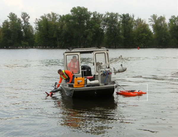
Picture of Boat and Suspended-Sediment Sampler with an Acoustic Doppler Current Profiler Highlighted
Picture of Boat and Suspended-Sediment Sampler with an Acoustic Doppler Current Profiler HighlightedThis picture shows two people on a boat in a river. One person is driving the boat and is in the boat cabin with the middle door being open. In the front of the boat, there is a person on the starboard side of the boat and is leaning over the water with their right hand holding onto a sensor.

Sediment sampling and surrogates
Sediment sampling and surrogates. Sediment work using physical samplers, laser diffraction, and acoustics on the Illinois River near Chillicothe, Illinois, May 11, 2011.
Sediment sampling and surrogates. Sediment work using physical samplers, laser diffraction, and acoustics on the Illinois River near Chillicothe, Illinois, May 11, 2011.

Measuring discharge during May 2011 Memphis, Tennessee flood
Measuring discharge during May 2011 Memphis, Tennessee floodMeasuring discharge during May 2011 Memphis, Tennessee flood
Measuring discharge during May 2011 Memphis, Tennessee flood
Measuring discharge during May 2011 Memphis, Tennessee floodMeasuring discharge during May 2011 Memphis, Tennessee flood

Cleaning Debris to Measure Outflow
Hydrologic Technicians Donnie Keeling (Murray, KY) and Trent Legg (Mt. Vernon, IL) clean debris from road bridge in the lower end of the New Madrid Floodway so a boat can be launched to measure outflow of the Birds Point-New Madrid Floodway.
Hydrologic Technicians Donnie Keeling (Murray, KY) and Trent Legg (Mt. Vernon, IL) clean debris from road bridge in the lower end of the New Madrid Floodway so a boat can be launched to measure outflow of the Birds Point-New Madrid Floodway.

Outflow of Birds Point-New Madrid Floodway
Outflow #1 of Birds Point-New Madrid Floodway. The Levee was detonated May 5, 2011 to allow water to return to the Mississippi River. Photo taken from inside floodway. Flow is coming into the floodway at a rate of 15,000 cubic feet per second (cfs).
Outflow #1 of Birds Point-New Madrid Floodway. The Levee was detonated May 5, 2011 to allow water to return to the Mississippi River. Photo taken from inside floodway. Flow is coming into the floodway at a rate of 15,000 cubic feet per second (cfs).