
Bank operated cableway setup using Streampro Trimaran
Images
Explore water-related photography, imagery, and illustrations.
Filter Total Items: 2584

Tethered Boat Deployment 2
Bank operated cableway setup using Streampro Trimaran

Our Great Falls
Great Falls Park in Mclean, VA.
Great Falls Park in Mclean, VA.

Red River of the North at Fargo ND
The Red River of the North at Fargo, North Dakota on May 21, 2010.
The Red River of the North at Fargo, North Dakota on May 21, 2010.

Pembina River
The Pembina River at Neche, ND with the streamgage house to the left top hiding in some trees.
The Pembina River at Neche, ND with the streamgage house to the left top hiding in some trees.

Pembina River
The Pembina River at Neche, North Dakota.
The Pembina River at Neche, North Dakota.

Where Two Rivers Meet
This photo of the confluence of the St. Croix River and the Mississippi River highlights the distinct contrast between water quality of the two rivers. Photo was taken during a flight searching for radio-tagged birds.
This photo of the confluence of the St. Croix River and the Mississippi River highlights the distinct contrast between water quality of the two rivers. Photo was taken during a flight searching for radio-tagged birds.

Carol Simons Collecting Water Samples at Sand Harbor, Lake Tahoe
Carol Simons Collecting Water Samples at Sand Harbor, Lake TahoeCarol Simons, from the Carnelian Bay Field Office of the California Water Science Center, collecting recreational water QW point-sampling for fecal indicator Bacteria at Sand Harbor in Lake Tahoe.

View of the Sampling Site for Collecting Water Samples at Sand Harbor, Lake Tahoe
View of the Sampling Site for Collecting Water Samples at Sand Harbor, Lake TahoeView of the sampling site for collecting recreational water QW point-sampling for fecal indicator Bacteria at Zephyr Cove in Lake Tahoe.
View of the Sampling Site for Collecting Water Samples at Sand Harbor, Lake Tahoe
View of the Sampling Site for Collecting Water Samples at Sand Harbor, Lake TahoeView of the sampling site for collecting recreational water QW point-sampling for fecal indicator Bacteria at Zephyr Cove in Lake Tahoe.

Carol Simons Collecting Water Samples at Zephyr Cove, Lake Tahoe
Carol Simons Collecting Water Samples at Zephyr Cove, Lake TahoeCarol Simons, from the Carnelian Bay Field Office of the California Water Science Center, collecting recreational water QW point-sampling for fecal indicator Bacteria at Zephyr Cove in Lake Tahoe.

Carol Simons Collecting Water Samples at Sand Harbor, Lake Tahoe
Carol Simons Collecting Water Samples at Sand Harbor, Lake TahoeCarol Simons, from the Carnelian Bay Field Office of the California Water Science Center, collecting recreational water QW point-sampling for fecal indicator Bacteria at Sand Harbor in Lake Tahoe.

Pembina River
Pembina River in May at Neche, North Dakota.
Pembina River in May at Neche, North Dakota.
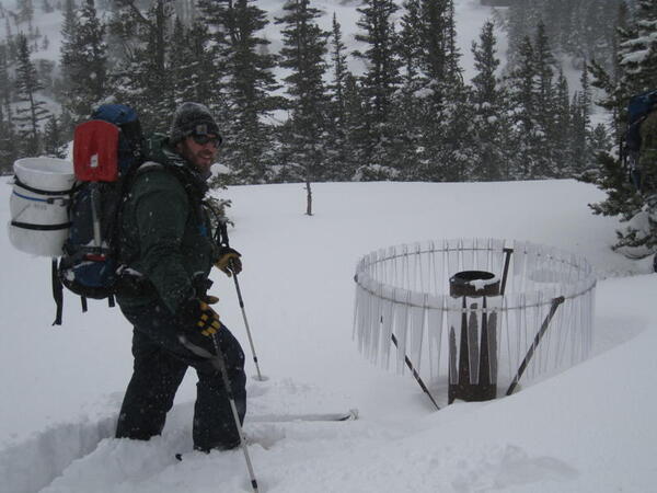
Visiting an atmospheric deposition monitoring site in Loch Vale, Colorado
Visiting an atmospheric deposition monitoring site in Loch Vale, ColoradoUSGS-funded research scientist Kevin McCluney makes a site visit to the Loch Vale, Colorado atmospheric deposition monitoring station via skis. This station is a long-term research site within the National Atmospheric Monitoring Program network.

Cannonball River
The Cannonball River in the spring at Breien, ND.
The Cannonball River in the spring at Breien, ND.

Cannonball River
Cannonball River at Breien, ND.
Cannonball River at Breien, ND.

ModelMuse: Name File
Screen capture of ModelMuse.
The image is intended to be used to introduce a video.
Screen capture of ModelMuse.
The image is intended to be used to introduce a video.

Using Comments in ModelMuse
Screen capture of the ModelMuse Data Sets dialog box with the words "Comments can be a useful way of documenting how your model is constructed."
Screen capture of the ModelMuse Data Sets dialog box with the words "Comments can be a useful way of documenting how your model is constructed."

Water-quality Sampling with DH-81
Collection of surface-water samples in South Dakota using DH-81.
Collection of surface-water samples in South Dakota using DH-81.