An official website of the United States government
Here's how you know
Official websites use .gov
A .gov website belongs to an official government organization in the United States.
Secure .gov websites use HTTPS
A lock () or https:// means you’ve safely connected to the .gov website. Share sensitive information only on official, secure websites.
The Next Generation Water Observing System (NGWOS) provides high-fidelity, real-time data on water quantity, quality, and use to support modern prediction and decision-support systems that are necessary for informing water operations on a daily basis and decision-making during water emergencies. The headwaters of the Colorado and Gunnison River Basins provide an opportunity to implement NGWOS in a snowmelt-dominated system in the mountain west.
The U.S. Geological Survey is integrating its water science programs to better address the Nation’s greatest water-resource challenges. Plans and activities are underway to intensively study at least ten Integrated Water Science (IWS) basins - medium-sized watersheds (10,000-20,000 square miles) and underlying aquifers – throughout the United States over the coming decade to improve understanding of water availability in a wide range of environmental, hydrologic, and landscape settings. Each IWS basin will represent a larger region, and high-density monitoring and cutting-edge research will be used to better understand and model factors affecting water availability (quantity, quality, and use) in the basins, the larger regions, and the Nation.
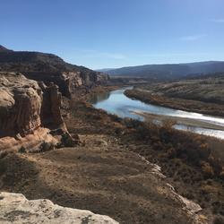
Figure 1. Integrated Water Science activities in the Upper Colorado River Basin (UCRB) will include prediction and assessments of water availability. High-fidelity data collection, observations, and data delivery through the Next Generation Water Observing Systems (NGWOS) Program includes installing new monitoring equipment and enhancing existing monitoring networks in the Colorado River Headwaters and Gunnison River subbasins (UCOL).
The Upper Colorado River Basin (UCRB) was selected as the second IWS basin because of its importance as a regional water resource in the western US (fig 1). Within the UCRB, the Colorado River Headwaters and Gunnison River subbasins (UCOL; fig. 1) were selected as the study area for NGWOS activities because this area provides an opportunity to develop high-fidelity observations in a snowmelt-dominated system of the mountain west. Regional modeling and assessments in the UCRB will include evaluations of core indicators for water-availability in addition to focused studies related to the effects of snowpack accumulation and melt on water-budget components and water quality, with an emphasis on salinity. Through the NGWOS Program, existing snow, streamflow, groundwater, and water-quality monitoring networks are being expanded to include state-of-the art data collection that will support hydrologic modeling and advance understanding of snow-dominated hydrologic systems.
Water Resources Challenges in the Colorado River Basin
The Colorado River, with its system of reservoirs and water conveyance infrastructure provides water to more than 40 million people and nearly 5.5 million acres of farmland across the western United States and Mexico. Colorado River and its main tributaries originate in high-elevation mountains of northeastern Utah, western Wyoming, and central Colorado, that surround the UCRB. Spring snowmelt and streamflow from the headwater areas of the UCRB are central to water availability throughout the basin. After 20 years of drought, and the decline of water levels in Lake Powell and Lake Mead, the two largest reservoirs within the Colorado River Basin, a Drought Contingency Plan was signed in April 2019, by the U.S. Department of the Interior, Bureau of Reclamation, and representatives from all seven basin states.
The effect of salinity (dissolved solids) on water availability is also a major concern in the Colorado River Basin in both the United States and Mexico, where high salinity levels cause damages to infrastructure and reduce agricultural yields. The Colorado River is naturally saline because of the underlying geology and climate, although both natural and anthropogenic sources contribute salinity to the river (Kenney et al., 2009; Miller et al., 2017). Natural sources, including geologic sources (sedimentary rocks) and saline springs, contribute about 68 percent of the salinity load to the river with the remaining 32 percent contributed by irrigated agricultural land and other anthropogenic sources (Miller et al., 2017).
USGS Upper Colorado River Basin IWS Study Area
The UCRB IWS study area is composed of the drainage basins of the Green and Colorado River upstream from Lees Ferry, Arizona (fig 1, USGS site 0938000, Colorado River at Lees Ferry, AZ) and includes Lake Powell. Most of the precipitation in the UCRB falls as snow, and the annual hydrologic cycle is characterized by a winter snowpack accumulation followed by a spring snowmelt-runoff event that provides a critical source of streamflow, groundwater recharge, and reservoir storage in the basin. Streamflow runoff from the UCRB is eventually delivered to and stored in two major reservoirs – Lake Powell and Lake Mead, which serve as critical water supplies for the Lower Colorado River Basin. Planning for future water availability requires an understanding of the processes influencing the magnitude and timing of snowpack and snow melt, effects of climate and anthropogenic activities, and streamflow response. Long-term drought conditions facing the Colorado River Basin, interstate ramifications of the drought, water-quality issues, stakeholder support, and alignment with Department of Interior and USGS priorities make the UCRB well suited for modelling and assessment IWS activities.
Colorado Headwaters and Gunnison River Basins
Within the UCRB IWS Basin, the Colorado River Headwaters and Gunnison River subbasins (UCOL; fig. 1) were selected as the focus of NGWOS activities because this area provides an opportunity to develop high-fidelity observations in a snowmelt-dominated system of the mountain west. As drought conditions continue in the Colorado River Basin, the UCOL similarly continues to experience drought characterized by low snowpack accumulation and warm spring conditions (Milly and Dunne, 2020), which in some recent years has led to the complete lack of a spring-snowmelt streamflow peak. Drought conditions also can affect other water-budget components such as soil moisture, groundwater recharge, and stream base flow to reduce overall streamflow and ecological health. Wildland fires are becoming more frequent in response to drought conditions, and recent (2020) fires in the UCOL burned directly along the main stem of the Colorado River. The subsequent monsoonal rains on burn scars generated landslide and debris flows disrupting transportation, and commerce in addition to adversely affecting downstream water availability, water quality, and ecosystems. This drought-affected and snowmelt-dominated hydrologic system provides opportunity for monitoring of snowpack and the associated hydrologic, water quality, and ecologic responses in support of modeling and assessment studies.
Next Generation Water Observing Systems (NGWOS) in the Upper Colorado River Basin
The USGS NGWOS program is generating high-fidelity, real-time data on water quantity, quality, and use to support water-availability predictions and assessments in the IWS basins. Through modernized data acquisition and delivery systems, these data also are publicly available for informing water operations and decision making especially during water emergencies. In the UCRB, the USGS began planning NGWOS activities in 2019 (project year 1), primarily focused on the UCOL headwaters basins. Initial installations and stakeholder engagement in 2020 led to installation of about half of the planned monitoring infrastructure by the end of 2021 (project year 3). New monitoring, research, and methods development for snow, soil moisture, streamflow, groundwater monitoring, and remote-sensing applications are focused in the UCOL basin with extensions and upgrades to key locations areas in the larger UCRB. Installation of monitoring infrastructure and related studies in the UCRB will continue through 2023 (year 5), and operation and maintenance of NGWOS deployments will continue through the 10-year lifespan of the project.
Kenney, T.A., Gerner, S.J., Buto, S.G., and Spangler, L.E., 2009, Spatially referenced statistical assessment of dissolved-solids load sources and transport in streams of the upper Colorado river basin: U.S. Geological Survey Scientific Investigations Report 2009–5007.
Miller, M.P., Buto, S.G., Lambert, P.M., and Rumsey, C.A., 2017, Enhanced and updated spatially referenced statistical assessment of dissolved-solids load sources and transport in streams of the upper Colorado river basin: U.S. Geological Survey Scientific Investigations Report 2017–5009
The Upper Colorado River Basin (UCRB) provides drinking water for 40 million people in the United States and Mexico. USGS research in the UCRB examines the key potential factors affecting water supply in the upper portion of the basin—snow processes and water storage, wildfire and basin hydrology, and salinity concentrations and water quality.
Integrated Water Science Basins: Upper Colorado River
The Upper Colorado River Basin (UCRB) provides drinking water for 40 million people in the United States and Mexico. USGS research in the UCRB examines the key potential factors affecting water supply in the upper portion of the basin—snow processes and water storage, wildfire and basin hydrology, and salinity concentrations and water quality.
The USGS Water Resources Mission Area is assessing how much water is available for human and ecological needs in the United States and identifying where and when the Nation may have challenges meeting its demand for water.
Integrated Water Availability Assessments Fundamentals
The USGS Water Resources Mission Area is assessing how much water is available for human and ecological needs in the United States and identifying where and when the Nation may have challenges meeting its demand for water.
The USGS Integrated Water Prediction science program is focused on developing and improving model code, workflows, and applications of core water availability components at a national extent.
The USGS Integrated Water Prediction science program is focused on developing and improving model code, workflows, and applications of core water availability components at a national extent.
Regional Water Availability Assessments are scientific assessments of water availability in different hydrologic regions across the Nation. In the Upper Colorado River Basin, the USGS will conduct a focused assessment of how snowpack and snowmelt influence hydrology and water quality, and an integrated and comprehensive assessment of multiple water quantity, quality and use factors.
Regional Water Availability Assessment: Upper Colorado River Basin
Regional Water Availability Assessments are scientific assessments of water availability in different hydrologic regions across the Nation. In the Upper Colorado River Basin, the USGS will conduct a focused assessment of how snowpack and snowmelt influence hydrology and water quality, and an integrated and comprehensive assessment of multiple water quantity, quality and use factors.
The U.S. Geological Survey is integrating its water science programs to better address the Nation’s greatest water resource challenges. At the heart of this effort are plans to intensively study several Integrated Water Science (IWS) basins—medium-sized watersheds (10,000-20,000 square miles) and underlying aquifers—over the next decade. The IWS basins will represent a wide range of environmental...
The U.S. Geological Survey is integrating its water science programs to better address the Nation’s greatest water resource challenges. At the heart of this effort are plans to intensively study several Integrated Water Science (IWS) basins—medium-sized watersheds (10,000-20,000 square miles) and underlying aquifers—over the next decade. The IWS basins will represent a wide range of environmental...
The Next Generation Water Observing System (NGWOS) supports water availability assessments, management, and prediction by enhancing water observations in basins that represent major U.S. hydrologic regions. NGWOS provides high-resolution, real-time data on water quantity, quality, and use, as well as advance the development and application of new sensor technologies and remote sensing methods.
The Next Generation Water Observing System (NGWOS) supports water availability assessments, management, and prediction by enhancing water observations in basins that represent major U.S. hydrologic regions. NGWOS provides high-resolution, real-time data on water quantity, quality, and use, as well as advance the development and application of new sensor technologies and remote sensing methods.
The Next Generation Water Observing System provides high-fidelity, real-time data on water quantity, quality, and use to support modern water prediction and decision-support systems that are necessary for informing water operations on a daily basis and decision-making during water emergencies. The Illinois River Basin provides an opportunity to implement the NGWOS in a system challenged by an...
Next Generation Water Observing System: Illinois River Basin
The Next Generation Water Observing System provides high-fidelity, real-time data on water quantity, quality, and use to support modern water prediction and decision-support systems that are necessary for informing water operations on a daily basis and decision-making during water emergencies. The Illinois River Basin provides an opportunity to implement the NGWOS in a system challenged by an...
The Next Generation Water Observing System (NGWOS) supports water availability assessments, management, and prediction by enhancing water observations in basins that represent major U.S. hydrologic regions. The Delaware River Basin was the first Integrated Water Science basin selected, providing an opportunity to implement the NGWOS program in a nationally important, complex interstate river...
Next Generation Water Observing System: Delaware River Basin
The Next Generation Water Observing System (NGWOS) supports water availability assessments, management, and prediction by enhancing water observations in basins that represent major U.S. hydrologic regions. The Delaware River Basin was the first Integrated Water Science basin selected, providing an opportunity to implement the NGWOS program in a nationally important, complex interstate river...
The challenges of providing safe and sustainable water supplies for human and ecological uses and protecting lives and property during water emergencies are well recognized. The U.S. Geological Survey (USGS) plays an essential role in meeting these challenges through its observational networks and renowned water science and research activities (National Academies of Science, Engineering...
Authors
Sandra M. Eberts, Chad R. Wagner, Michael D. Woodside
The United States faces growing challenges to its water supply, infrastructure, and aquatic ecosystems because of population growth, climate change, floods, and droughts. To help address these challenges, the U.S. Geological Survey Water Resources Mission Area is integrating recent advances in monitoring, research, and modeling to improve assessments of water availability throughout the...
The United States faces growing challenges to its water supply, infrastructure, and aquatic ecosystems because of population growth, climate change, floods and droughts, and aging water delivery systems. To help address these challenges, the U.S. Geological Survey (USGS) Water Resources Mission Area has established new strategic priorities that capitalize on the operational and...
Authors
Mark P. Miller, Brian R. Clark, Sandra M. Eberts, Patrick M. Lambert, Patricia Toccalino
The sensitivity of river discharge to climate-system warming is highly uncertain, and the processes that govern river discharge are poorly understood, which impedes climate-change adaptation. A prominent exemplar is the Colorado River, where meteorological drought and warming are shrinking a water resource that supports more than 1 trillion dollars of economic activity per year. A Monte...
The challenges of providing safe and sustainable water supplies for human and ecological uses and protecting lives and property during water emergencies are well recognized. The U.S. Geological Survey (USGS) plays an essential role in meeting these challenges through its observational networks and renowned water science and research activities (National Academies of Science, Engineering...
Authors
Sandra M. Eberts, Chad R. Wagner, Michael D. Woodside
Approximately 6.4 million tons of dissolved solids are discharged from the Upper Colorado River Basin (UCRB) to the Lower Colorado River Basin each year. This results in substantial economic damages, and tens of millions of dollars are spent annually on salinity control projects designed to reduce salinity loads in surface waters of the UCRB. Dissolved solids in surface water and...
Authors
Matthew P. Miller, Susan G. Buto, Patrick M. Lambert, Christine A. Rumsey
The Upper Colorado River Basin (UCRB) discharges more than 6 million tons of dissolved solids annually, about 40 to 45 percent of which are attributed to agricultural activities. The U.S. Department of the Interior estimates economic damages related to salinity in excess of $330 million annually in the Colorado River Basin. Salinity in the UCRB, as measured by dissolved-solids load and
Authors
Terry A. Kenney, Steven J. Gerner, Susan G. Buto, Lawrence E. Spangler
A majority of the water in the western U.S. comes from snowmelt, but changes in the timing, magnitude, and duration of snowmelt can alter water availability downstream. This data visualization story explores what changing snowmelt means for water in the West, and how new USGS efforts can advance snow science by modeling snowpack and snowmelt dynamics and linking these results to streamflow.
The U.S. Geological Survey has chosen the Illinois River Basin as the next watershed to be studied by its scientists as part of a large-scale effort...
The Next Generation Water Observing System (NGWOS) provides high-fidelity, real-time data on water quantity, quality, and use to support modern prediction and decision-support systems that are necessary for informing water operations on a daily basis and decision-making during water emergencies. The headwaters of the Colorado and Gunnison River Basins provide an opportunity to implement NGWOS in a snowmelt-dominated system in the mountain west.
The U.S. Geological Survey is integrating its water science programs to better address the Nation’s greatest water-resource challenges. Plans and activities are underway to intensively study at least ten Integrated Water Science (IWS) basins - medium-sized watersheds (10,000-20,000 square miles) and underlying aquifers – throughout the United States over the coming decade to improve understanding of water availability in a wide range of environmental, hydrologic, and landscape settings. Each IWS basin will represent a larger region, and high-density monitoring and cutting-edge research will be used to better understand and model factors affecting water availability (quantity, quality, and use) in the basins, the larger regions, and the Nation.
Figure 1. Integrated Water Science activities in the Upper Colorado River Basin (UCRB) will include prediction and assessments of water availability. High-fidelity data collection, observations, and data delivery through the Next Generation Water Observing Systems (NGWOS) Program includes installing new monitoring equipment and enhancing existing monitoring networks in the Colorado River Headwaters and Gunnison River subbasins (UCOL).
The Upper Colorado River Basin (UCRB) was selected as the second IWS basin because of its importance as a regional water resource in the western US (fig 1). Within the UCRB, the Colorado River Headwaters and Gunnison River subbasins (UCOL; fig. 1) were selected as the study area for NGWOS activities because this area provides an opportunity to develop high-fidelity observations in a snowmelt-dominated system of the mountain west. Regional modeling and assessments in the UCRB will include evaluations of core indicators for water-availability in addition to focused studies related to the effects of snowpack accumulation and melt on water-budget components and water quality, with an emphasis on salinity. Through the NGWOS Program, existing snow, streamflow, groundwater, and water-quality monitoring networks are being expanded to include state-of-the art data collection that will support hydrologic modeling and advance understanding of snow-dominated hydrologic systems.
Water Resources Challenges in the Colorado River Basin
The Colorado River, with its system of reservoirs and water conveyance infrastructure provides water to more than 40 million people and nearly 5.5 million acres of farmland across the western United States and Mexico. Colorado River and its main tributaries originate in high-elevation mountains of northeastern Utah, western Wyoming, and central Colorado, that surround the UCRB. Spring snowmelt and streamflow from the headwater areas of the UCRB are central to water availability throughout the basin. After 20 years of drought, and the decline of water levels in Lake Powell and Lake Mead, the two largest reservoirs within the Colorado River Basin, a Drought Contingency Plan was signed in April 2019, by the U.S. Department of the Interior, Bureau of Reclamation, and representatives from all seven basin states.
The effect of salinity (dissolved solids) on water availability is also a major concern in the Colorado River Basin in both the United States and Mexico, where high salinity levels cause damages to infrastructure and reduce agricultural yields. The Colorado River is naturally saline because of the underlying geology and climate, although both natural and anthropogenic sources contribute salinity to the river (Kenney et al., 2009; Miller et al., 2017). Natural sources, including geologic sources (sedimentary rocks) and saline springs, contribute about 68 percent of the salinity load to the river with the remaining 32 percent contributed by irrigated agricultural land and other anthropogenic sources (Miller et al., 2017).
USGS Upper Colorado River Basin IWS Study Area
The UCRB IWS study area is composed of the drainage basins of the Green and Colorado River upstream from Lees Ferry, Arizona (fig 1, USGS site 0938000, Colorado River at Lees Ferry, AZ) and includes Lake Powell. Most of the precipitation in the UCRB falls as snow, and the annual hydrologic cycle is characterized by a winter snowpack accumulation followed by a spring snowmelt-runoff event that provides a critical source of streamflow, groundwater recharge, and reservoir storage in the basin. Streamflow runoff from the UCRB is eventually delivered to and stored in two major reservoirs – Lake Powell and Lake Mead, which serve as critical water supplies for the Lower Colorado River Basin. Planning for future water availability requires an understanding of the processes influencing the magnitude and timing of snowpack and snow melt, effects of climate and anthropogenic activities, and streamflow response. Long-term drought conditions facing the Colorado River Basin, interstate ramifications of the drought, water-quality issues, stakeholder support, and alignment with Department of Interior and USGS priorities make the UCRB well suited for modelling and assessment IWS activities.
Colorado Headwaters and Gunnison River Basins
Within the UCRB IWS Basin, the Colorado River Headwaters and Gunnison River subbasins (UCOL; fig. 1) were selected as the focus of NGWOS activities because this area provides an opportunity to develop high-fidelity observations in a snowmelt-dominated system of the mountain west. As drought conditions continue in the Colorado River Basin, the UCOL similarly continues to experience drought characterized by low snowpack accumulation and warm spring conditions (Milly and Dunne, 2020), which in some recent years has led to the complete lack of a spring-snowmelt streamflow peak. Drought conditions also can affect other water-budget components such as soil moisture, groundwater recharge, and stream base flow to reduce overall streamflow and ecological health. Wildland fires are becoming more frequent in response to drought conditions, and recent (2020) fires in the UCOL burned directly along the main stem of the Colorado River. The subsequent monsoonal rains on burn scars generated landslide and debris flows disrupting transportation, and commerce in addition to adversely affecting downstream water availability, water quality, and ecosystems. This drought-affected and snowmelt-dominated hydrologic system provides opportunity for monitoring of snowpack and the associated hydrologic, water quality, and ecologic responses in support of modeling and assessment studies.
Next Generation Water Observing Systems (NGWOS) in the Upper Colorado River Basin
The USGS NGWOS program is generating high-fidelity, real-time data on water quantity, quality, and use to support water-availability predictions and assessments in the IWS basins. Through modernized data acquisition and delivery systems, these data also are publicly available for informing water operations and decision making especially during water emergencies. In the UCRB, the USGS began planning NGWOS activities in 2019 (project year 1), primarily focused on the UCOL headwaters basins. Initial installations and stakeholder engagement in 2020 led to installation of about half of the planned monitoring infrastructure by the end of 2021 (project year 3). New monitoring, research, and methods development for snow, soil moisture, streamflow, groundwater monitoring, and remote-sensing applications are focused in the UCOL basin with extensions and upgrades to key locations areas in the larger UCRB. Installation of monitoring infrastructure and related studies in the UCRB will continue through 2023 (year 5), and operation and maintenance of NGWOS deployments will continue through the 10-year lifespan of the project.
Kenney, T.A., Gerner, S.J., Buto, S.G., and Spangler, L.E., 2009, Spatially referenced statistical assessment of dissolved-solids load sources and transport in streams of the upper Colorado river basin: U.S. Geological Survey Scientific Investigations Report 2009–5007.
Miller, M.P., Buto, S.G., Lambert, P.M., and Rumsey, C.A., 2017, Enhanced and updated spatially referenced statistical assessment of dissolved-solids load sources and transport in streams of the upper Colorado river basin: U.S. Geological Survey Scientific Investigations Report 2017–5009
The Upper Colorado River Basin (UCRB) provides drinking water for 40 million people in the United States and Mexico. USGS research in the UCRB examines the key potential factors affecting water supply in the upper portion of the basin—snow processes and water storage, wildfire and basin hydrology, and salinity concentrations and water quality.
Integrated Water Science Basins: Upper Colorado River
The Upper Colorado River Basin (UCRB) provides drinking water for 40 million people in the United States and Mexico. USGS research in the UCRB examines the key potential factors affecting water supply in the upper portion of the basin—snow processes and water storage, wildfire and basin hydrology, and salinity concentrations and water quality.
The USGS Water Resources Mission Area is assessing how much water is available for human and ecological needs in the United States and identifying where and when the Nation may have challenges meeting its demand for water.
Integrated Water Availability Assessments Fundamentals
The USGS Water Resources Mission Area is assessing how much water is available for human and ecological needs in the United States and identifying where and when the Nation may have challenges meeting its demand for water.
The USGS Integrated Water Prediction science program is focused on developing and improving model code, workflows, and applications of core water availability components at a national extent.
The USGS Integrated Water Prediction science program is focused on developing and improving model code, workflows, and applications of core water availability components at a national extent.
Regional Water Availability Assessments are scientific assessments of water availability in different hydrologic regions across the Nation. In the Upper Colorado River Basin, the USGS will conduct a focused assessment of how snowpack and snowmelt influence hydrology and water quality, and an integrated and comprehensive assessment of multiple water quantity, quality and use factors.
Regional Water Availability Assessment: Upper Colorado River Basin
Regional Water Availability Assessments are scientific assessments of water availability in different hydrologic regions across the Nation. In the Upper Colorado River Basin, the USGS will conduct a focused assessment of how snowpack and snowmelt influence hydrology and water quality, and an integrated and comprehensive assessment of multiple water quantity, quality and use factors.
The U.S. Geological Survey is integrating its water science programs to better address the Nation’s greatest water resource challenges. At the heart of this effort are plans to intensively study several Integrated Water Science (IWS) basins—medium-sized watersheds (10,000-20,000 square miles) and underlying aquifers—over the next decade. The IWS basins will represent a wide range of environmental...
The U.S. Geological Survey is integrating its water science programs to better address the Nation’s greatest water resource challenges. At the heart of this effort are plans to intensively study several Integrated Water Science (IWS) basins—medium-sized watersheds (10,000-20,000 square miles) and underlying aquifers—over the next decade. The IWS basins will represent a wide range of environmental...
The Next Generation Water Observing System (NGWOS) supports water availability assessments, management, and prediction by enhancing water observations in basins that represent major U.S. hydrologic regions. NGWOS provides high-resolution, real-time data on water quantity, quality, and use, as well as advance the development and application of new sensor technologies and remote sensing methods.
The Next Generation Water Observing System (NGWOS) supports water availability assessments, management, and prediction by enhancing water observations in basins that represent major U.S. hydrologic regions. NGWOS provides high-resolution, real-time data on water quantity, quality, and use, as well as advance the development and application of new sensor technologies and remote sensing methods.
The Next Generation Water Observing System provides high-fidelity, real-time data on water quantity, quality, and use to support modern water prediction and decision-support systems that are necessary for informing water operations on a daily basis and decision-making during water emergencies. The Illinois River Basin provides an opportunity to implement the NGWOS in a system challenged by an...
Next Generation Water Observing System: Illinois River Basin
The Next Generation Water Observing System provides high-fidelity, real-time data on water quantity, quality, and use to support modern water prediction and decision-support systems that are necessary for informing water operations on a daily basis and decision-making during water emergencies. The Illinois River Basin provides an opportunity to implement the NGWOS in a system challenged by an...
The Next Generation Water Observing System (NGWOS) supports water availability assessments, management, and prediction by enhancing water observations in basins that represent major U.S. hydrologic regions. The Delaware River Basin was the first Integrated Water Science basin selected, providing an opportunity to implement the NGWOS program in a nationally important, complex interstate river...
Next Generation Water Observing System: Delaware River Basin
The Next Generation Water Observing System (NGWOS) supports water availability assessments, management, and prediction by enhancing water observations in basins that represent major U.S. hydrologic regions. The Delaware River Basin was the first Integrated Water Science basin selected, providing an opportunity to implement the NGWOS program in a nationally important, complex interstate river...
The challenges of providing safe and sustainable water supplies for human and ecological uses and protecting lives and property during water emergencies are well recognized. The U.S. Geological Survey (USGS) plays an essential role in meeting these challenges through its observational networks and renowned water science and research activities (National Academies of Science, Engineering...
Authors
Sandra M. Eberts, Chad R. Wagner, Michael D. Woodside
The United States faces growing challenges to its water supply, infrastructure, and aquatic ecosystems because of population growth, climate change, floods, and droughts. To help address these challenges, the U.S. Geological Survey Water Resources Mission Area is integrating recent advances in monitoring, research, and modeling to improve assessments of water availability throughout the...
The United States faces growing challenges to its water supply, infrastructure, and aquatic ecosystems because of population growth, climate change, floods and droughts, and aging water delivery systems. To help address these challenges, the U.S. Geological Survey (USGS) Water Resources Mission Area has established new strategic priorities that capitalize on the operational and...
Authors
Mark P. Miller, Brian R. Clark, Sandra M. Eberts, Patrick M. Lambert, Patricia Toccalino
The sensitivity of river discharge to climate-system warming is highly uncertain, and the processes that govern river discharge are poorly understood, which impedes climate-change adaptation. A prominent exemplar is the Colorado River, where meteorological drought and warming are shrinking a water resource that supports more than 1 trillion dollars of economic activity per year. A Monte...
The challenges of providing safe and sustainable water supplies for human and ecological uses and protecting lives and property during water emergencies are well recognized. The U.S. Geological Survey (USGS) plays an essential role in meeting these challenges through its observational networks and renowned water science and research activities (National Academies of Science, Engineering...
Authors
Sandra M. Eberts, Chad R. Wagner, Michael D. Woodside
Approximately 6.4 million tons of dissolved solids are discharged from the Upper Colorado River Basin (UCRB) to the Lower Colorado River Basin each year. This results in substantial economic damages, and tens of millions of dollars are spent annually on salinity control projects designed to reduce salinity loads in surface waters of the UCRB. Dissolved solids in surface water and...
Authors
Matthew P. Miller, Susan G. Buto, Patrick M. Lambert, Christine A. Rumsey
The Upper Colorado River Basin (UCRB) discharges more than 6 million tons of dissolved solids annually, about 40 to 45 percent of which are attributed to agricultural activities. The U.S. Department of the Interior estimates economic damages related to salinity in excess of $330 million annually in the Colorado River Basin. Salinity in the UCRB, as measured by dissolved-solids load and
Authors
Terry A. Kenney, Steven J. Gerner, Susan G. Buto, Lawrence E. Spangler
A majority of the water in the western U.S. comes from snowmelt, but changes in the timing, magnitude, and duration of snowmelt can alter water availability downstream. This data visualization story explores what changing snowmelt means for water in the West, and how new USGS efforts can advance snow science by modeling snowpack and snowmelt dynamics and linking these results to streamflow.
The U.S. Geological Survey has chosen the Illinois River Basin as the next watershed to be studied by its scientists as part of a large-scale effort...