
The “OnDemand - 100K - BND - State - Label” graphic depiction applies to:
Multimedia
Images

OnDemand - 100K - BND - State - Label
The “OnDemand - 100K - BND - State - Label” graphic depiction applies to:

The National Map 3D Viewer 3D View from Wotans Throne, CA
The National Map 3D Viewer 3D View from Wotans Throne, CAScreenshot of the National Map 3D Viewer showing a 3D view looking northeast. The location is near Wotans Throne.
The National Map 3D Viewer 3D View from Wotans Throne, CA
The National Map 3D Viewer 3D View from Wotans Throne, CAScreenshot of the National Map 3D Viewer showing a 3D view looking northeast. The location is near Wotans Throne.

The National Map 3D Viewer, Elevation Profile
Screenshot of the National Map 3D Viewer showing the elevation profile tool. The screen shot is of the Inyo National Forest area of California, near Tunnabora Peak.
Screenshot of the National Map 3D Viewer showing the elevation profile tool. The screen shot is of the Inyo National Forest area of California, near Tunnabora Peak.
The National Map 3D Viewer
This is a screen shot of the National Map (TNM) 3D Viewer Application. This new application will replace the existing TNM Viewer on or around April 7th 2025
This is a screen shot of the National Map (TNM) 3D Viewer Application. This new application will replace the existing TNM Viewer on or around April 7th 2025
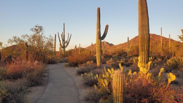
Desert Discovery Trail, Saguaro National Park (Elizabeth McCartney)
Desert Discovery Trail, Saguaro National Park (Elizabeth McCartney)Desert scenery highlighting tall Saguaro cacti and other types of desert vegetation with a paved trail running through the middle. There are low hills in the distance and the scene is bathed in the soft yellow light of sunset.

TNMCorps Status Map: Finished Points as of 05/02/2022
TNMCorps Status Map: Finished Points as of 05/02/2022A map showing all the finished points as of May 2, 2022. These points do not need to be checked again at this time. They have a blue, purple, or yellow border in the editor.
TNMCorps Status Map: Finished Points as of 05/02/2022
TNMCorps Status Map: Finished Points as of 05/02/2022A map showing all the finished points as of May 2, 2022. These points do not need to be checked again at this time. They have a blue, purple, or yellow border in the editor.