
The “OnDemand - 100K - BND - State - Label” graphic depiction applies to:
Images
National Geospatial Technical Operations Center images.
Filter Total Items: 48

OnDemand - 100K - BND - State - Label
The “OnDemand - 100K - BND - State - Label” graphic depiction applies to:

The National Map 3D Viewer 3D View from Wotans Throne, CA
The National Map 3D Viewer 3D View from Wotans Throne, CAScreenshot of the National Map 3D Viewer showing a 3D view looking northeast. The location is near Wotans Throne.
The National Map 3D Viewer 3D View from Wotans Throne, CA
The National Map 3D Viewer 3D View from Wotans Throne, CAScreenshot of the National Map 3D Viewer showing a 3D view looking northeast. The location is near Wotans Throne.

The National Map 3D Viewer, Elevation Profile
Screenshot of the National Map 3D Viewer showing the elevation profile tool. The screen shot is of the Inyo National Forest area of California, near Tunnabora Peak.
Screenshot of the National Map 3D Viewer showing the elevation profile tool. The screen shot is of the Inyo National Forest area of California, near Tunnabora Peak.
The National Map 3D Viewer
This is a screen shot of the National Map (TNM) 3D Viewer Application. This new application will replace the existing TNM Viewer on or around April 7th 2025
This is a screen shot of the National Map (TNM) 3D Viewer Application. This new application will replace the existing TNM Viewer on or around April 7th 2025
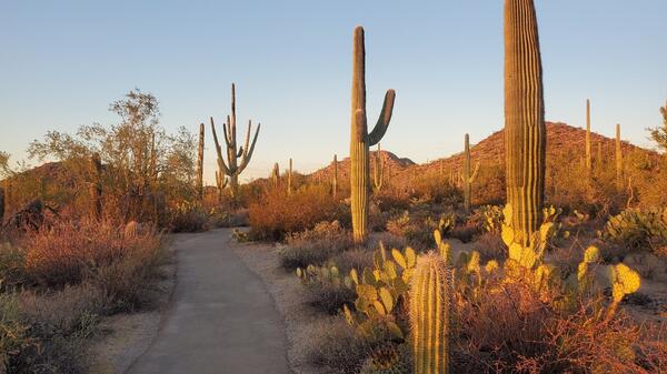
Desert Discovery Trail, Saguaro National Park (Elizabeth McCartney)
Desert Discovery Trail, Saguaro National Park (Elizabeth McCartney)Desert scenery highlighting tall Saguaro cacti and other types of desert vegetation with a paved trail running through the middle. There are low hills in the distance and the scene is bathed in the soft yellow light of sunset.

TNMCorps Status Map: Finished Points as of 05/02/2022
TNMCorps Status Map: Finished Points as of 05/02/2022A map showing all the finished points as of May 2, 2022. These points do not need to be checked again at this time. They have a blue, purple, or yellow border in the editor.
TNMCorps Status Map: Finished Points as of 05/02/2022
TNMCorps Status Map: Finished Points as of 05/02/2022A map showing all the finished points as of May 2, 2022. These points do not need to be checked again at this time. They have a blue, purple, or yellow border in the editor.

TNMCorps Status Map: Volunteer Contributions through March 31, 2022
TNMCorps Status Map: Volunteer Contributions through March 31, 2022A map showing volunteer contributions from the inception of TNMCorps through March 31, 2022. Contributions are displayed by fiscal year with contributions during the current fiscal year displayed by quarter. Points are color-coded on a graduated gray-to-red scale; older points are gray and newer points are red.

TNMCorps Status Map: Standard Edited Points as of 05/02/2022
TNMCorps Status Map: Standard Edited Points as of 05/02/2022A map showing all the standard edited points as of May 2, 2022. These points need to be Peer Reviewed or checked by an Advanced Editor. They have a green border in the editor.
TNMCorps Status Map: Standard Edited Points as of 05/02/2022
TNMCorps Status Map: Standard Edited Points as of 05/02/2022A map showing all the standard edited points as of May 2, 2022. These points need to be Peer Reviewed or checked by an Advanced Editor. They have a green border in the editor.

TNMCorps Status Map: Unedited Points as of 05/02/2022
TNMCorps Status Map: Unedited Points as of 05/02/2022A map showing all the remaining unedited points as of May 2, 2022. These points need to be checked by a Standard Editor or an Advanced Editor. They have a red border in the editor.
TNMCorps Status Map: Unedited Points as of 05/02/2022
TNMCorps Status Map: Unedited Points as of 05/02/2022A map showing all the remaining unedited points as of May 2, 2022. These points need to be checked by a Standard Editor or an Advanced Editor. They have a red border in the editor.

Review Queue Tab
Screenshot showing the review queue tab and window with list of points flagged for review.
Screenshot showing the review queue tab and window with list of points flagged for review.

TNMCorps Points with no Edit History - Ambulance Service
TNMCorps Points with no Edit History - Ambulance ServiceA map showing all the edited ambulance service points with no edit history. Ambulance and EMS stations frequently close, open, or move so this is an important feature to reverify.
TNMCorps Points with no Edit History - Ambulance Service
TNMCorps Points with no Edit History - Ambulance ServiceA map showing all the edited ambulance service points with no edit history. Ambulance and EMS stations frequently close, open, or move so this is an important feature to reverify.

TNMCorps Points with no Edit History - Law Enforcement
TNMCorps Points with no Edit History - Law EnforcementA map showing all the edited law enforcement points with no edit history. Points with no edit history are concentrated in Pennsylvania, Virginia, West Virginia, Kentucky, Tennessee, and North Carolina, all of which are states that participated in some of TNMCorps’ earliest mapping challenges from 2014 and 2015.

TNMCorps Points with no Edit History - Cemeteries
A map showing all the edited cemetery points with no edit history. Cemeteries are much less likely to change as some of the other feature types, therefore, we’re asking standard editors to focus on other points with no edit history before cemeteries. For our peer reviewers and advanced editors, we ask that you check the edited (green) points.
A map showing all the edited cemetery points with no edit history. Cemeteries are much less likely to change as some of the other feature types, therefore, we’re asking standard editors to focus on other points with no edit history before cemeteries. For our peer reviewers and advanced editors, we ask that you check the edited (green) points.

TNMCorps Points with no Edit History - Post Office
TNMCorps Points with no Edit History - Post OfficeA map showing all the edited post offices with no edit history. Post offices may see moderate change as facilities relocate to handle additional capacity and in response to USPS restructuring, fluctuating populations, etc.

TNMCorps Points with no Edit History - Prison / Correctional Facility
TNMCorps Points with no Edit History - Prison / Correctional FacilityA map showing all the edited prison / correctional facility points with no edit history. Prisons are another feature that was targeted by earlier challenges, so points are concentrated in these earlier challenge states (i.e., Virginia, West Virginia, Kentucky, Tennessee, and North Carolina).

TNMCorps Points with no Edit History - All Schools
TNMCorps Points with no Edit History - All SchoolsA map showing all the edited schools with no edit history. Many points are clustered around major cities. Schools can be prone to frequent changes, so it’s especially important that these points are researched and reverified.

TNMCorps Points with no Edit History - Hospital / Medical Center
TNMCorps Points with no Edit History - Hospital / Medical CenterA map showing all the edited hospital / medical center points with no edit history. Like prisons, hospitals don’t change as much as some of the other feature types. Perhaps the most frequent change these points will see is in naming conventions.

Future City Hall Challenges April 2022
Map of the United States showing future city hall challenge states and incorporated places with a population greater than 500 without a city hall.
Map of the United States showing future city hall challenge states and incorporated places with a population greater than 500 without a city hall.

Example of Cemetery Point Without an Address
This cemetery was included in the review queue because the address field was blank. The editor was correct by leaving the field blank due to the cemetery not having an address nor being near any roads.
This cemetery was included in the review queue because the address field was blank. The editor was correct by leaving the field blank due to the cemetery not having an address nor being near any roads.

TNMCorps Points with no Edit History - All Feature Types
TNMCorps Points with no Edit History - All Feature TypesA map showing edited points with no edit history for all feature types.
TNMCorps Points with no Edit History - All Feature Types
TNMCorps Points with no Edit History - All Feature TypesA map showing edited points with no edit history for all feature types.

TNMCorps Points with no Edit History - Fire Stations
TNMCorps Points with no Edit History - Fire StationsA map showing all the edited fire station points with no edit history. Points are clustered in states along the Atlantic and Pacific coasts along with a few inland states (e.g., Utah, South Dakota, West Virginia, etc.).