
Landslide and Debris-Flow Event Summaries
Landslide and Debris-Flow Event Summaries
Landslide and Debris-Flow Event Summaries
Filter Total Items: 14
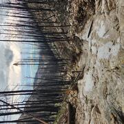
2024 Elk Fire Postfire Flooding and Debris Flows
In the early fall 2024, the Elk Fire burned nearly 100,000 acres along the eastern edge of the Bighorn Mountains in Wyoming’s Bighorn National Forest. Less than one year later, on the evening of July 15, 2025, thunderstorms swept across the burned area, triggering floods and debris flows in several steep watersheds. This geonarrative explores why the Elk Fire left the landscape vulnerable to...
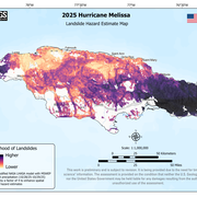
2025 Hurricane Melissa Landslide Hazards
Hurricane Melissa, a category 5 storm, made landfall on October 28, 2025, near the border of Westmoreland and St. Elizabeth Parishes, southwestern Jamaica. The storm brought heavy rainfall, strong winds, and flooding to much of the Caribbean. In Jamaica, intense rainfall on steep mountainous terrain raised concern about potential landslides. This landslide event page serves as an event summary to...
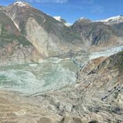
2025 Tracy Arm Landslide-Generated Tsunami
A landslide above the toe of the South Sawyer Glacier failed into the waters of Tracy Arm, south of Juneau, Alaska, producing a tsunami on Sunday, August 10th, 2025, at 05:26 AKDT / 13:26 UTC. No injuries or fatalities have been reported. This page may be updated as more information about the event is obtained. Steep, mountainous landslide areas are inherently unstable and will continue to change...

2024 Hurricane Helene Landslide Hazards
Hurricane Helene produced widespread and damaging landslides. The USGS is mapping landslides to support our partners. This page provides information about the extent and severity of landslide impacts. Hurricane Helene made landfall in Florida as a Category 4 storm on Thursday, September 26th, 2024. The hurricane continued across the southern Appalachian Mountains producing record rainfall. This...

2024 Pedersen Glacier Lagoon Landslide-Generated Tsunami
A 4.6-million-cubic-meter (equivalent to over 184 Olympic-sized swimming pools) landslide produced a tsunami in Pedersen Glacier lagoon, southwest of Seward, Alaska on Wednesday, August 7th, 2024, at approximately 04:55 AKDT / 12:55 UTC. Surveying indicated that the landslide generated tsunami runup of at least 17 meters (approx. 56 ft) in the upper Pedersen Glacier lagoon*, reducing to about one...

Dixie Fire Post-Fire Debris Flows: A Tale of Two Storms
This new geonarrative (Esri story map) highlights two storm events and their postfire impacts in the Dixie burn area.

Columbia River Gorge Landslides
Extreme rainfall during two atmospheric river events in January 2021 and January 2022 triggered a series of debris flows in the Columbia River Gorge, Oregon. The flows had significant impacts, including multiple highway closures and one fatality. This story map highlights rainfall data and observations of debris flow deposits by the Oregon Department of Geology and Mineral Industries (DOGAMI)...

Cameron Peak Fire, Colorado: Flooding and Debris Flows - July 20, 2021
On Thursday, August 13, 2020, at approximately 1:45 PM MDT, the Cameron Peak fire was reported in steep, rugged terrain 15 miles southwest of Red Feather Lakes, Colorado, near Cameron Pass. The fire spread rapidly due to extreme temperatures, strong winds, and high fuel loads. The largest wildfire in Colorado history, the Cameron Peak fire burned 845 square kilometers (sq km) on the Arapaho and...

Glenwood Canyon, Colorado, Flooding and Debris Flows: 2021
Summer storms on the Grizzly Creek burn area have resulted in repeated flooding and debris flows that are having enormous impacts in Glenwood Canyon. This Story Map collection summarizes the June and July events.

Bond Fire Debris Flows, California: January 25 and 28, 2021
On Wednesday, December 2, 2020 at approximately 10:15 PM PST, the Bond wildfire ignited in Orange County, California, burning partially within the Cleveland Forest, near Silverado Canyon just north of the area burned by the October 2020 Silverado fire. The fire burned 27 square kilometers (sq km) prior to containment on December 10, 2020 (CalFire). Fuels were primarily chaparral, brush, and tall...

Northern and Central California Debris Flows - January 2021
An atmospheric river (AR) moved into California late on the evening of January 26, 2021, bringing intermittent heavy rainfall that resulted in flooding, debris flows, and heavy snowfall at high elevations.

Tadpole Fire Debris Flows, New Mexico: July and September 2020
On Saturday, June 6, 2020 at approximately 1:45 PM MDT, the Tadpole wildfire ignited in the Gila National Forest, approximately 19 kilometers (km) north of Silver City, Grant County, New Mexico. The fire burned 45 square kilometers prior to containment in early July, 2020 (Inciweb). Fuels were primarily timber with grass understory, brush, and chaparral. The Brush, Bringham, and Bighorn fires in...