Rocks and Paleomagnetics Laboratory
Building 800, CalVO contact Anthony Pivarunas

Researchers at the USGS Paleomagnetics Laboratory study the magnetic record contained in rocks and other natural materials. Their research ranges from the small – signal-carrying minerals within specimens – to the large – regional aeromagnetic surveys and continent-scale tectonic movements. The past variations of the geomagnetic field make paleomagnetism a precise, powerful tool which applies to a wide variety of important geological questions.
- Motions of the Earth’s crust. Paleomagnetic data provide the basic framework for plate tectonic theory. They can be used to understand the geological history of regions, such as in assessing earthquake hazards and fault activity in structurally complex regions. Aeromagnetic data reveal structures and rock unit contacts.
- Ages of rocks. Paleomagnetic data can help determine the frequency and duration of volcanic eruptions. They can aid in the mapping of active volcanoes by correlating rocks. The paleomagnetism of mineral deposits can assist in figuring out their age.
- Behavior of the geomagnetic field. Earth’s magnetic field shields us from dangerous solar radiation. Paleomagnetic data help determine the speed and duration of polarity reversals, when the geomagnetic shield becomes small. The strength of the field through time, paleointensity, can be a correlative tool as well as affecting some radioisotopes.
Active Personnel:
Anthony Pivarunas – apivarunas@usgs.gov
Margaret Avery – mavery@usgs.gov
Affiliated and Emeriti:
Duane Champion
Jonathan Hagstrum
Rick Blakely
Ray Wells
Ed Mankinen
Jack Hillhouse
Sherman Gromme
Michel Prevot
Norman Watkins
Partners: Caltech, Stanford, UC Santa Cruz, UC Berkeley, Berkeley Geochronology Center, RAPID Consortium, University of Florida, SUNY College at Geneseo
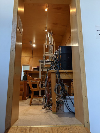
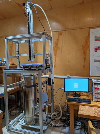
The Paleomagnetics Laboratory is presently located in Building 800, Room 1250 at Moffett Field, CA. The laboratory contains a variety of instruments used to analyze paleomagnetic and rock magnetic properties. The data acquired here support many mission-related USGS activities. The most recent addition to the laboratory is a fully automatic cryogenic magnetometer with in-line alternating field demagnetization capability. It is capable of precise and rapid measurement of materials with a wide range of magnetic signal intensity to determine their original magnetizations as well as any superimposed secondary magnetizations.
Specific Equipment

- Superconducting cryogenic magnetometer: This instrument uses three SQUIDs (superconducting quantum interference devices) to measure the magnetizations of specimens and has a wide practical sensitivity from 1 emu to 5 x 10⁻⁸ emu. It is capable of automated measurement and alternating-field demagnetization routines as well as a variety of rock magnetic tests. Typical measurement time per sample is under 2 minutes; data are logged and reduced on a computer and are cross-compatible with a variety of analytical software.
- Demagnetization equipment, alternating-field (AF) and thermal: An AF unit is located in-line with the cryogenic magnetometer setup. It can produce a maximum magnetic field of 800 Gauss, that is, over 1000 times the Earth’s magnetic field. This ‘cleans’ secondary magnetization from samples. Thermal demagnetization is carried out in a shielded furnace which can reach 700 °C and holds up to 48 standard specimens per 1-hour heating/cooling cycle conducted. Both demagnetization devices are housed in a shielded room, minimizing magnetic acquisition during measurements.
- MFK1 Kappabridge: This instrument measures magnetic susceptibility at high, low, and room temperatures. This helps determine rock fabrics (from deformation lava flows, or paleo-currents) and identify magnetic minerals which carry the remanent signal in our specimens.
- Shielded room: The magnetometer, demagnetization equipment, and samples undergoing analysis are housed in a magnetically shielded room that reduces the ambient field to 1% of its normal value. This room is wrapped in multiple layers of transformer steel to achieve this effect. The weak field in this room reduces measurement time, and minimizes contamination from stray magnetic fields in both samples and equipment.
- Rock drills and other field equipment: The laboratory maintains a full complement of portable rock drills, sample orienting equipment, sediment sampling tools, and double-bladed diamond saws to prepare samples.
Pioneering research on the geomagnetic polarity time scale performed in the original laboratory was instrumental in confirming the hypothesis of seafloor spreading and led to the development of the theory of plate tectonics. During 1959-1966, the scientists of the Rock Magnetics Project in Menlo Park were involved in a race to prove that reverse-polarity magnetization in rocks was the result of global reversals of the geomagnetic field, and not due to variation of individual rock magnetic properties. To prove their case, the scientists had to show that rocks of the same age throughout the world had the same magnetic polarity. They collected samples from Alaska to Antarctica and from Hawaii to New Mexico. In the laboratory, they measured the magnetic polarity of rock samples with a spinner magnetometer and determined the ages of samples with an argon mass spectrometer. As more and more polarity-age pairs were gathered at this laboratory and elsewhere, a consistent pattern began to emerge, demonstrating that indeed the earth’s magnetic field had reversed polarity many times in the past. Within a few years, the Geomagnetic Polarity Reversal Timescale was published. When it was recognized that the polarity timescale was matched by magnetic patterns on the seafloor, the concepts of seafloor-spreading and the mobility of continents became widely accepted. This discovery about earth magnetism became the foundation for modern plate tectonic models that explain mountain building, the formation of ocean basins, and the distribution of continents.
In 1995, recognition of the fundamental scientific contributions made by Allan Cox, Richard Doell, and Brent Dalrymple from 1959 to 1966 led to listing of the Rock Magnetics Laboratory on the National Register of Historic Places (#94001647). The original laboratory was in a neglected storage building previously used as a laundry for Dibble Army Hospital during World War II. Cox and Doell established their Rock Magnetics Laboratory in this “tarpaper shack” in 1959, soon after the USGS acquired the army site. The nearly all-wood construction of the building was ideal for their purposes. Construction of the new laboratory in 1996 required removal of the original building, the essence of which is presently preserved in an exhibit in Building 16. A documentary video, “Secrets in Stone,” was also commissioned as part of the exhibit. The 30-minute video chronicles events from the discovery of geomagnetic reversals to the acceptance of plate tectonics and explains the essential scientific principles in terms understandable to a general audience. Colorful animations and interviews with some of the scientists involved in this scientific discovery bring the story to life for viewers. The movie is available in DVD format; contact Anthony Pivarunas to obtain a copy.
The laboratory still contains some of the original equipment used in these experiments, a tribute to curiosity, ingenuity, and science.

