Routine measurement at USGS stream gage 05383950 Root River, MN
Routine measurement at USGS stream gage 05383950 Root River, MNPatrick Farrell makes a snowy, routine measurement at USGS stream gage 05383950 Root River near Pilot Mount, MN.

Official websites use .gov
A .gov website belongs to an official government organization in the United States.
Secure .gov websites use HTTPS
A lock () or https:// means you’ve safely connected to the .gov website. Share sensitive information only on official, secure websites.
Access all multimedia to include images, video, audio, webcams, before-after imagery, and more. Filter and explore with filtering options to refine search.
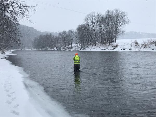
Patrick Farrell makes a snowy, routine measurement at USGS stream gage 05383950 Root River near Pilot Mount, MN.
Patrick Farrell makes a snowy, routine measurement at USGS stream gage 05383950 Root River near Pilot Mount, MN.

A structure called a dolphin, permanently affixed in the sediment, stands in Grizzly Bay near San Francisco, CA, with a weather station installed on top. The USGS will use the data from the weather station in conjunction with other oceanographic data, in their studies of sediment movement in the bay.
A structure called a dolphin, permanently affixed in the sediment, stands in Grizzly Bay near San Francisco, CA, with a weather station installed on top. The USGS will use the data from the weather station in conjunction with other oceanographic data, in their studies of sediment movement in the bay.

Pete Dal Ferro and Andrew Stevens, both from the USGS Pacific Coastal and Marine Science Center (PCMSC) in Santa Cruz, California, install a Vaisala WXT weather station in Grizzly Bay, east of San Pablo Bay and northeast of San Francisco.
Pete Dal Ferro and Andrew Stevens, both from the USGS Pacific Coastal and Marine Science Center (PCMSC) in Santa Cruz, California, install a Vaisala WXT weather station in Grizzly Bay, east of San Pablo Bay and northeast of San Francisco.

Scientists from the USGS Pacific Coastal and Marine Science Center in their vessel jewell, docked at Belden's Landing Water Access Facility on Montezuma Slough. They are preparing for a day of sampling on Grizzly Bay, where they study how sediment moves through sensitive coastal environments.
Scientists from the USGS Pacific Coastal and Marine Science Center in their vessel jewell, docked at Belden's Landing Water Access Facility on Montezuma Slough. They are preparing for a day of sampling on Grizzly Bay, where they study how sediment moves through sensitive coastal environments.

From left to right, USGS scientists Sam McGill, Lucas WinklerPrins, David Hart, Selina Davila Olivera, and Pete Dal Ferro work on Grizzly Bay on the vessel Jewell, to collect sediment samples using the GOMEX box corer.
From left to right, USGS scientists Sam McGill, Lucas WinklerPrins, David Hart, Selina Davila Olivera, and Pete Dal Ferro work on Grizzly Bay on the vessel Jewell, to collect sediment samples using the GOMEX box corer.

On PCMSC vessel Jewell, a team of USGS scientists sit in Grizzly Bay, a baylet of San Francisco Bay in Solano County, California. USGS collects sediment samples to study how sediment moves through sensitive coastal environments like this.
On PCMSC vessel Jewell, a team of USGS scientists sit in Grizzly Bay, a baylet of San Francisco Bay in Solano County, California. USGS collects sediment samples to study how sediment moves through sensitive coastal environments like this.

USGS science crew works to free the muddy sediment from a GOMEX box corer. They are on board the Pacific Coastal and Marine Science Center's vessel Jewell on Grizzly Bay in the San Francisco Bay area.
USGS science crew works to free the muddy sediment from a GOMEX box corer. They are on board the Pacific Coastal and Marine Science Center's vessel Jewell on Grizzly Bay in the San Francisco Bay area.

A weather station, installed in the middle of Grizzly Bay east of San Pablo Bay (near San Francisco), gets its power from a small solar panel. Data collected from the station is transmitted via a wireless modem. Far in the background is the city of Benicia, and the plume rising into the sky is water vapor emitted from the Benicia oil refinery.
A weather station, installed in the middle of Grizzly Bay east of San Pablo Bay (near San Francisco), gets its power from a small solar panel. Data collected from the station is transmitted via a wireless modem. Far in the background is the city of Benicia, and the plume rising into the sky is water vapor emitted from the Benicia oil refinery.

Wildlife out in force in Yellowstone as streamgagers headed into streamgages on Firehole and Gibbon Rivers. The thermal activity of the area means that the Firehole River is almost always ice free.
Wildlife out in force in Yellowstone as streamgagers headed into streamgages on Firehole and Gibbon Rivers. The thermal activity of the area means that the Firehole River is almost always ice free.

Wildlife out in force in Yellowstone as streamgagers headed into streamgages on Firehole and Gibbon Rivers. The thermal activity of the area means that the Firehole River is almost always ice free.
Wildlife out in force in Yellowstone as streamgagers headed into streamgages on Firehole and Gibbon Rivers. The thermal activity of the area means that the Firehole River is almost always ice free.

In the year since Kīlauea Volcano’s notable 2018 eruption ended, the lower East Rift Zone has been relatively quiet. But USGS Hawaiian Volcano Observatory scientists continue to gain insight into the eruption through ongoing research and monitoring. Some of the many questions asked by island residents include, Why did the fissures erupt along a linear pattern?
In the year since Kīlauea Volcano’s notable 2018 eruption ended, the lower East Rift Zone has been relatively quiet. But USGS Hawaiian Volcano Observatory scientists continue to gain insight into the eruption through ongoing research and monitoring. Some of the many questions asked by island residents include, Why did the fissures erupt along a linear pattern?

Semipalmated Sandpipers with A) Leg bands only (no flag), or B) leg bands plus flag From: Leg flags do not affect shorebird nests: https://doi.org/10.1111/jofo.12264
Semipalmated Sandpipers with A) Leg bands only (no flag), or B) leg bands plus flag From: Leg flags do not affect shorebird nests: https://doi.org/10.1111/jofo.12264

This thermal video of the fissure 8 cone shows that small areas of higher temperatures (greater than 100 degrees Celsius, or 212 degrees Fahrenheit) are present on the cone. Those hotter areas likely represent residual heat in the cone and the underlying fissure. USGS video by M. Patrick.
This thermal video of the fissure 8 cone shows that small areas of higher temperatures (greater than 100 degrees Celsius, or 212 degrees Fahrenheit) are present on the cone. Those hotter areas likely represent residual heat in the cone and the underlying fissure. USGS video by M. Patrick.

This video clip shows a flyover of fissure 8 on Jan. 21. During the 2018 eruption, lava spilled out from the cone into a channel that extended towards the north. Lava traveled approximately 13 km (8 miles) to reach the ocean at Kapoho Bay. USGS video by M. Patrick.
This video clip shows a flyover of fissure 8 on Jan. 21. During the 2018 eruption, lava spilled out from the cone into a channel that extended towards the north. Lava traveled approximately 13 km (8 miles) to reach the ocean at Kapoho Bay. USGS video by M. Patrick.

Congressional event following the 6.4 earthquake in Puerto Rico held on Jan. 20, 2020. Dr. Jonathan Godt (USGS) and Dr. Elizabeth A. Vanacore (Red Sismica Puerto Rico) answered questions to congressmen: Yauco's major, Bill Posey, Jenniffer González Colón, Stephanie Murphy, Donna Shalala
Congressional event following the 6.4 earthquake in Puerto Rico held on Jan. 20, 2020. Dr. Jonathan Godt (USGS) and Dr. Elizabeth A. Vanacore (Red Sismica Puerto Rico) answered questions to congressmen: Yauco's major, Bill Posey, Jenniffer González Colón, Stephanie Murphy, Donna Shalala

Overview of the Congressional event following the 6.4 earthquake in Puerto Rico. Bottom of picture: congressmen. Center: Dianne Lopez, Lindsay Davis, Donyelle Davis
Overview of the Congressional event following the 6.4 earthquake in Puerto Rico. Bottom of picture: congressmen. Center: Dianne Lopez, Lindsay Davis, Donyelle Davis

One of the houses destroyed during the 6.4 earthquake in Puerto Rico.
One of the houses destroyed during the 6.4 earthquake in Puerto Rico.

A close-up view of the Kilauea pond shows the color variations across the surface, and sharp boundaries among zones of different color.
A close-up view of the Kilauea pond shows the color variations across the surface, and sharp boundaries among zones of different color.
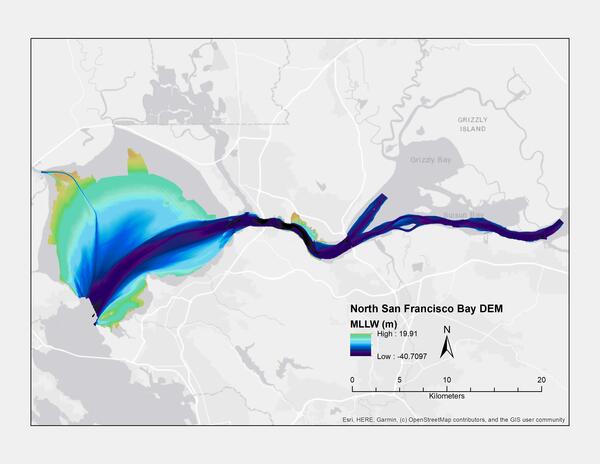
Digital elevation model (DEM) of northern San Francisco Bay, California, created using bathymetry data collected between 1999 and 2016 (MLLW)
Digital elevation model (DEM) of northern San Francisco Bay, California, created using bathymetry data collected between 1999 and 2016 (MLLW)

This image created using the Continuous Bathymetry and Elevation Models of the Massachusetts Coastal Zone and Continental Shelf, shows the entrance to the Buzzards Bay entrance to the Cape Cod Canal.
This image created using the Continuous Bathymetry and Elevation Models of the Massachusetts Coastal Zone and Continental Shelf, shows the entrance to the Buzzards Bay entrance to the Cape Cod Canal.