Eagle Creek above Findlay OH - muddy waters and debris
Eagle Creek above Findlay OH - muddy waters and debrisEagle Creek above Findlay OH - muddy waters and debris

Official websites use .gov
A .gov website belongs to an official government organization in the United States.
Secure .gov websites use HTTPS
A lock () or https:// means you’ve safely connected to the .gov website. Share sensitive information only on official, secure websites.
Access all multimedia to include images, video, audio, webcams, before-after imagery, and more. Filter and explore with filtering options to refine search.

Eagle Creek above Findlay OH - muddy waters and debris
Eagle Creek above Findlay OH - muddy waters and debris

Eagle Creek above Findlay OH - view looking upstream towards gage
Eagle Creek above Findlay OH - view looking upstream towards gage

Flushing stomach contents from a live resident Chinook salmon for an investigation of cannibalism and predation impacts.
Flushing stomach contents from a live resident Chinook salmon for an investigation of cannibalism and predation impacts.

Kīlauea summit photo taken on September 6, 2018.
Kīlauea summit photo taken on September 6, 2018.

USGS personnel on the deck of the R/V Hugh R.
USGS personnel on the deck of the R/V Hugh R.

Finishing up water-quality sampling on Blacks Fork, the last field run of the summer for two of our interns.
Finishing up water-quality sampling on Blacks Fork, the last field run of the summer for two of our interns.

A closer view of the small cone forming on the floor of crater within fissure 8 today (Sept. 5). By this morning, bits of molten lava emitted from the cone every few seconds had built it up to an estimated height of around 3-4 m (about 10-13 ft).
A closer view of the small cone forming on the floor of crater within fissure 8 today (Sept. 5). By this morning, bits of molten lava emitted from the cone every few seconds had built it up to an estimated height of around 3-4 m (about 10-13 ft).

In preperation for Apollo 15, David Scott and James Irwin trained with a training version of the Lunar Rover known as the "Grover". Apollo 15 was the first mission to bring a rover. This allowed the astronauts to cover a larger distance and explore a larger area.
In preperation for Apollo 15, David Scott and James Irwin trained with a training version of the Lunar Rover known as the "Grover". Apollo 15 was the first mission to bring a rover. This allowed the astronauts to cover a larger distance and explore a larger area.

Karen Murray and a visitor at Canajoharie Creek near Canajoharie, NY during ecological sampling for the National Water Quality Assessment project.
Karen Murray and a visitor at Canajoharie Creek near Canajoharie, NY during ecological sampling for the National Water Quality Assessment project.
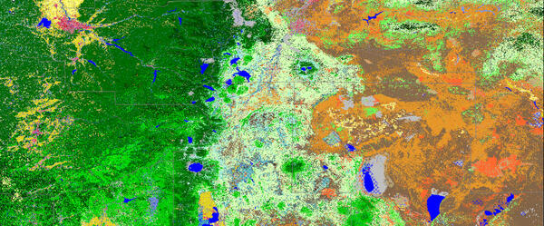
LANDFIRE Existing Vegetation Type imagery.
LANDFIRE Existing Vegetation Type imagery.

Landsat-8 nighttime thermal infrared image from April 2017 showing the Tern Lake area. In Yellowstone, temperatures are extremely cold at night in the winter, and most lakes are frozen (dark pixels). West Tern Lake seems to be thawing here - perhaps it receives some thermal waters from nearby hot springs.
Landsat-8 nighttime thermal infrared image from April 2017 showing the Tern Lake area. In Yellowstone, temperatures are extremely cold at night in the winter, and most lakes are frozen (dark pixels). West Tern Lake seems to be thawing here - perhaps it receives some thermal waters from nearby hot springs.

LSPIV camera setup over USGS gage 09333500 Dirty Devil River above Poison Springs Wash nr Hanksville, UT.

Hormones and pharmaceuticals, widely used for treatment of humans, domestic animals, and livestock, have the potential to enter the environment, including groundwater. In 2009, nearly 70% of Americans took at least one prescription drug, and more than half took 2 or more.
Hormones and pharmaceuticals, widely used for treatment of humans, domestic animals, and livestock, have the potential to enter the environment, including groundwater. In 2009, nearly 70% of Americans took at least one prescription drug, and more than half took 2 or more.

School Branch at Maloney Road near Brownsburg IN - dry stream
School Branch at Maloney Road near Brownsburg IN - dry stream

School Branch at Maloney Road near Brownsburg IN - equipment
School Branch at Maloney Road near Brownsburg IN - equipment

School Branch at Maloney Road near Brownsburg IN - measurement
School Branch at Maloney Road near Brownsburg IN - measurement

School Branch at Maloney Road near Brownsburg IN - measuring stream width
School Branch at Maloney Road near Brownsburg IN - measuring stream width

School Branch at Maloney Road near Brownsburg IN - no flow
School Branch at Maloney Road near Brownsburg IN - no flow

School Branch at Maloney Road near Brownsburg IN - stream measurement
School Branch at Maloney Road near Brownsburg IN - stream measurement

Serapeum, a Roman Marketplace in Pozzuoli, Italy, records deformation of Campi Flegrei caldera over two millennia.
Serapeum, a Roman Marketplace in Pozzuoli, Italy, records deformation of Campi Flegrei caldera over two millennia.

Northeast Region Photo Contest Winner | October 2018 | USGS at Work
USGS researchers deploying a prototype DTS fiber optic cable array in the Delaware River
Northeast Region Photo Contest Winner | October 2018 | USGS at Work
USGS researchers deploying a prototype DTS fiber optic cable array in the Delaware River