
Skinny Common Murre with keel protruding. Lower Cook Inlet, Alaska
All Multimedia
Access all multimedia to include images, video, audio, webcams, before-after imagery, and more. Filter and explore with filtering options to refine search.
Filter Total Items: 24926

Skinny Common Murre flying with keel protruding
Skinny Common Murre with keel protruding. Lower Cook Inlet, Alaska

View of Unalakleet from the air
Unalakleet village on the low-lying barrier spit at the inlet of the Unalakleet River and Norton Sound, Alaska.
Unalakleet village on the low-lying barrier spit at the inlet of the Unalakleet River and Norton Sound, Alaska.

Why do some Hawaii earthquakes occur so far offshore?
Why do some Hawaii earthquakes occur so far offshore?Many of the earthquakes in Hawaii that extend offshore and up the island chain are due to plate bending, or flexure. The upper panel shows magnitude-5 and greater earthquakes since 1861, with some notable events labeled.
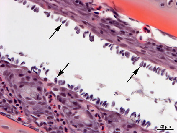
Gills from Lost River Suckers - heavy infestation of Ichthyobodo sp.
Gills from Lost River Suckers - heavy infestation of Ichthyobodo sp.Gills from Lost River suckers with a heavy infestation of Ichthyobodo sp. (arrows). Slide is stained with hematoxylin and eosin.
Gills from Lost River Suckers - heavy infestation of Ichthyobodo sp.
Gills from Lost River Suckers - heavy infestation of Ichthyobodo sp.Gills from Lost River suckers with a heavy infestation of Ichthyobodo sp. (arrows). Slide is stained with hematoxylin and eosin.

Returning to the Vessel After Sampling
Diver travelling along the surface of the lake along with the dive camera system. The crew on the boat are there to meet the divers along with pulling the center pivot back onto the boat with the help of the davit.
Diver travelling along the surface of the lake along with the dive camera system. The crew on the boat are there to meet the divers along with pulling the center pivot back onto the boat with the help of the davit.
Smallmouth Bass Checks Out Divers During a Transect
Smallmouth Bass Checks Out Divers During a TransectSmallmouth bass swimming near lake bottom. The camera pans up a couple times to show the center pivot where the diver is holding on.
Smallmouth Bass Checks Out Divers During a Transect
Smallmouth Bass Checks Out Divers During a TransectSmallmouth bass swimming near lake bottom. The camera pans up a couple times to show the center pivot where the diver is holding on.

A Peregrine Falcon flies off with a Black-legged Kittiwake
A Peregrine Falcon flies off with a Black-legged KittiwakeA Peregrine Falcon flies off with a Black-legged Kittiwake from its colony at Gull Island, Alaska.
A Peregrine Falcon flies off with a Black-legged Kittiwake
A Peregrine Falcon flies off with a Black-legged KittiwakeA Peregrine Falcon flies off with a Black-legged Kittiwake from its colony at Gull Island, Alaska.

Documenting August 2018 flooding in the Madison, Wisconsin, area
Documenting August 2018 flooding in the Madison, Wisconsin, areaA USGS hydrologist documents a flooded street near the Sugar River in Verona, Wisconsin. This image was taken after the area received near-record rainfall on August 20, 2018.

Image of the Week - One Year Ago: Eclipse Darkens Nebraska
Image of the Week - One Year Ago: Eclipse Darkens NebraskaA total solar eclipse darkened the skies over the United States on Aug. 21, 2017.
Fourteen states were in the path of totality, a 70-mile-wide band under which the moon fully blocked the sun for just under three minutes.

Kīlauea Volcano's Lower East Rift Zone
An Unmanned Aircraft Systems overflight of fissure 8 on August 21, 2018, showed no incandescence within the cinder cone. Minor amounts of gases, primarily steam, rose from the north wall of the cinder cone and from areas along the lower East Rift Zone.
An Unmanned Aircraft Systems overflight of fissure 8 on August 21, 2018, showed no incandescence within the cinder cone. Minor amounts of gases, primarily steam, rose from the north wall of the cinder cone and from areas along the lower East Rift Zone.

Twentymile River sonar on a bridge
Twentymile River sonar on a bridge
Twentymile River sonar on a bridge
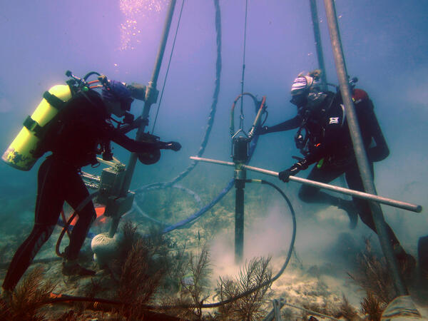
USGS scientists drill a coral-reef core in the Florida Keys
USGS scientists drill a coral-reef core in the Florida KeysResearch Oceanographer Lauren Toth and student volunteer Liz Whitcher drill a coral-reef core from a reef off Key West, Florida, in the Florida Keys National Marine Sanctuary. Photo taken under research permit FKNMS-2015-058. Credit: Anastasios Stathakopoulos, USGS.

Yellowstone National Park Dragonfly Mercury Project Sampling
Yellowstone National Park Dragonfly Mercury Project SamplingThis image shows citizen scientists along with National Park Service personnel identifying invertebrates as part of the Dragonfly Mercury Project.
Yellowstone National Park Dragonfly Mercury Project Sampling
Yellowstone National Park Dragonfly Mercury Project SamplingThis image shows citizen scientists along with National Park Service personnel identifying invertebrates as part of the Dragonfly Mercury Project.

7 months of no lava at Pu‘u ‘Ō‘ō heralds end of an e
7 months of no lava at Pu‘u ‘Ō‘ō heralds end of an ePu‘u ‘Ō‘ō on May 3, 2018, as viewed from the helicopter overflight. The crater floor is collapsed, and a thin plume escapes from the gaping crater. The west flank cracked on April 30th around 2:30 pm HST, and minor amounts of lava oozed out of the crack (line of steaming features) just before the plumbing system catastrophically failed.

A sensor data logger recovered from the floor of Yellowstone Lake in the Deep Ho
A sensor data logger recovered from the floor of Yellowstone Lake in the Deep HoA sensor data logger recovered from the floor of Yellowstone Lake in the Deep Hole area in 2018 shows signs of melting due to unexpectedly high temperatures in sediments up to ~3 ft (1 m) away from an active hydrothermal vent. Image acquired by the Global Foundation for Ocean Exploration ROV Yogi on August 4, 2018.

AppEEARS
This short video provides a quick look at the Application for Extracting and Exploring Analysis Ready Samples (AppEEARS). AppEEARS provides a simple and efficient way to subset, transform, and visualize geospatial data distributed from a variety of federal archives.
This short video provides a quick look at the Application for Extracting and Exploring Analysis Ready Samples (AppEEARS). AppEEARS provides a simple and efficient way to subset, transform, and visualize geospatial data distributed from a variety of federal archives.
")
Changes Over Time at Kīlauea (April - August 2018)
Changes Over Time at Kīlauea (April - August 2018)Changes at the summit of Kīlauea between April 14 and August 20, 2018, were captured by a USGS–Hawaiian Volcano Observatory camera. This time-lapse series includes roughly one image per day. The lava lake within Halema‘uma‘u is visible in April, with overflows onto the caldera floor on April 23.

Checking out the Gobies While Sampling
The camera glances at the bottom of the boat above and then pans down to the lake bottom. The lake bottom is covered in tons of round gobies swimming around in and out of the cladophora. Again the camera pans up to show a diver and the dive camera completing a transect in the distance.
The camera glances at the bottom of the boat above and then pans down to the lake bottom. The lake bottom is covered in tons of round gobies swimming around in and out of the cladophora. Again the camera pans up to show a diver and the dive camera completing a transect in the distance.

Curious Smallmouth Swims into Diver's POV
Smallmouth bass swimming in front of the dive camera system during a transect. Camera system is attached to the center pivot by a line in order to follow around in a circle.
Smallmouth bass swimming in front of the dive camera system during a transect. Camera system is attached to the center pivot by a line in order to follow around in a circle.

Divers Preparing to Sample Cladophora After Imaging
Divers Preparing to Sample Cladophora After ImagingDescending to the lake bottom to get ready for transects with the camera system and cladophora sampling. Organizing quadrats and sampling bags near the center pivot before sampling.
Divers Preparing to Sample Cladophora After Imaging
Divers Preparing to Sample Cladophora After ImagingDescending to the lake bottom to get ready for transects with the camera system and cladophora sampling. Organizing quadrats and sampling bags near the center pivot before sampling.

Hot spring waters with relatively high dissolved element concentrations on the f
Hot spring waters with relatively high dissolved element concentrations on the fHot spring waters with relatively high dissolved element concentrations on the floor of West Thumb, Yellowstone Lake. Image acquired by the Global Foundation for Ocean Exploration ROV Yogi on August 7, 2018.