
USGS Unmanned Aerial Systems (UAS) pilot, Elizabeth Pendleton, setting a target in Great Marsh, Sandy Neck Beach, Cape Cod, Massachusetts
All Multimedia
Access all multimedia to include images, video, audio, webcams, before-after imagery, and more. Filter and explore with filtering options to refine search.
Filter Total Items: 24926

Setting Targets in the Great Marsh, Cape Cod, MA
USGS Unmanned Aerial Systems (UAS) pilot, Elizabeth Pendleton, setting a target in Great Marsh, Sandy Neck Beach, Cape Cod, Massachusetts

Using drones to study groundwater
Did you know that plants can sometimes help us understand what is happening underground? Studying plants in an area can provide information about soil conditions, water availability, and water quality.
Did you know that plants can sometimes help us understand what is happening underground? Studying plants in an area can provide information about soil conditions, water availability, and water quality.

Algal Bloom in Willamette River
Algal bloom in the Ross Island Lagoon, Willamette River, Oregon.
Algal bloom in the Ross Island Lagoon, Willamette River, Oregon.

Dive camera system with attached scooter
Dive camera system with attached scooter
Dive camera system with attached scooter

Drone flight at Sandy Neck Beach, Cape Cod
Woods Hole Coastal and Marine Science Center Unmanned Aerial Systems (UAS) pilots Sandy Brosnahan (left) and Elizabeth Pendleton conduct a drone flight from atop a dune at Sandy Neck (Cape Cod).
Woods Hole Coastal and Marine Science Center Unmanned Aerial Systems (UAS) pilots Sandy Brosnahan (left) and Elizabeth Pendleton conduct a drone flight from atop a dune at Sandy Neck (Cape Cod).

Hot springs waters measured on Yellowstone Lake floor
Hot springs waters measured on Yellowstone Lake floorHot spring waters with relatively high dissolved element concentrations on the floor of West Thumb, Yellowstone Lake. Image acquired by the Global Foundation for Ocean Exploration ROV Yogi on August 7, 2018.

Image of the Week - 8 Million Landsat Scenes!
The Landsat archive has added its 8 millionth scene.
This stunning image was captured by Landsat 8 on July 28, 2018. It shows the coastline of Nordaustlandet, the second-largest island in Norway’s Svalbard archipelago.
The Landsat archive has added its 8 millionth scene.
This stunning image was captured by Landsat 8 on July 28, 2018. It shows the coastline of Nordaustlandet, the second-largest island in Norway’s Svalbard archipelago.

Kentucky River at Lock 2 at Lockport KY - pier at gage
Kentucky River at Lock 2 at Lockport KY - pier at gageKentucky River at Lock 2 at Lockport KY - pier at gage
Kentucky River at Lock 2 at Lockport KY - pier at gage
Kentucky River at Lock 2 at Lockport KY - pier at gageKentucky River at Lock 2 at Lockport KY - pier at gage

Kentucky River at Lock 2 at Lockport KY - USGS staff running levels
Kentucky River at Lock 2 at Lockport KY - USGS staff running levelsKentucky River at Lock 2 at Lockport KY - USGS staff running gage levels
Kentucky River at Lock 2 at Lockport KY - USGS staff running levels
Kentucky River at Lock 2 at Lockport KY - USGS staff running levelsKentucky River at Lock 2 at Lockport KY - USGS staff running gage levels

Kentucky River at Lock 2 at Lockport KY - view across the dam
Kentucky River at Lock 2 at Lockport KY - view across the damKentucky River at Lock 2 at Lockport KY - view across the dam
Kentucky River at Lock 2 at Lockport KY - view across the dam
Kentucky River at Lock 2 at Lockport KY - view across the damKentucky River at Lock 2 at Lockport KY - view across the dam

Kentucky River at Lock 2 at Lockport KY - view of the dam and piers
Kentucky River at Lock 2 at Lockport KY - view of the dam and piersKentucky River at Lock 2 at Lockport KY - view of the dam and piers
Kentucky River at Lock 2 at Lockport KY - view of the dam and piers
Kentucky River at Lock 2 at Lockport KY - view of the dam and piersKentucky River at Lock 2 at Lockport KY - view of the dam and piers

Sunrise at Jensen Beach, FL
A colorful sunrise appears over the horizon of a calm ocean offshore of Jensen Beach, Florida. USGS Scientist RC Mickey collects data for location and elevation of sea turtle crawls and associated beach profiles this stretch of coastline.
A colorful sunrise appears over the horizon of a calm ocean offshore of Jensen Beach, Florida. USGS Scientist RC Mickey collects data for location and elevation of sea turtle crawls and associated beach profiles this stretch of coastline.

The emission of volcanic gases, including sulfur dioxide and hydrogen sulfide, i
The emission of volcanic gases, including sulfur dioxide and hydrogen sulfide, iThe emission of volcanic gases, including sulfur dioxide and hydrogen sulfide, is not unusual at the summit of Kīlauea. However, sulfur dioxide gas emission rates are now lower than they have been since before 1983, with about 50 tonnes/day measured at the summit of the volcano on the day of this photo (October 24).

Aerial view of the fissure 8 cone
Aerial view of the fissure 8 cone and spillway captured by Civil Air Patrol during their overflight on August 7, 2018. View is toward the south.
Aerial view of the fissure 8 cone and spillway captured by Civil Air Patrol during their overflight on August 7, 2018. View is toward the south.

Kīlauea 2018 events mark a watershed for volcano science
Kīlauea 2018 events mark a watershed for volcano scienceThese two plots show summit tilt (ground deformation) and seismicity (earthquake counts) on Kīlauea Volcano between July 15 and August 5, 2018. A regular pattern emerged in which seismicity gradually increased over 1-3 days (bottom), until the caldera floor suddenly dropped several meters (yards) in a matter of seconds.

Lava Fountaining at Fissure 8
During this morning's overflight, HVO geologists observed low levels of lava fountaining within the fissure 8 spatter cone and crusted lava in the spillway and channel downstream. The significance of this change is not yet clear. Eruptions can wax and wane or pause for days to weeks before returning to high levels of lava discharge.
During this morning's overflight, HVO geologists observed low levels of lava fountaining within the fissure 8 spatter cone and crusted lava in the spillway and channel downstream. The significance of this change is not yet clear. Eruptions can wax and wane or pause for days to weeks before returning to high levels of lava discharge.

New outcrops make good geology
This aerial view of the western part of Kīlauea Volcano's caldera was taken on August 6, 2018. The down-dropped block is faulted about 120 m (400 feet) below the caldera floor. Many 19th-century lava flows are exposed in the fault scarps. Halema‘uma‘u (not visible) is to the left of this photo.
This aerial view of the western part of Kīlauea Volcano's caldera was taken on August 6, 2018. The down-dropped block is faulted about 120 m (400 feet) below the caldera floor. Many 19th-century lava flows are exposed in the fault scarps. Halema‘uma‘u (not visible) is to the left of this photo.

Overflight of Kīlauea Summit
Between mid-May and early August, 2018, the depth of Halema‘uma‘u more than tripled and its diameter more than doubled as magma from Kīlauea's shallow summit reservoir moved into the lower East Rift Zone. Evidence of subsidence is visible in this video, taken during an early morning helicopter overflight on August 6, 2018.
Between mid-May and early August, 2018, the depth of Halema‘uma‘u more than tripled and its diameter more than doubled as magma from Kīlauea's shallow summit reservoir moved into the lower East Rift Zone. Evidence of subsidence is visible in this video, taken during an early morning helicopter overflight on August 6, 2018.
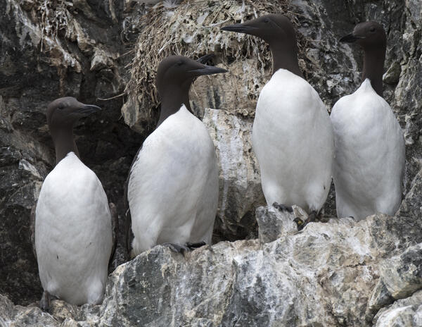
Skinny Common Murre with keel protruding (second from the left)
Skinny Common Murre with keel protruding (second from the left)Skinny Common Murre with keel protruding (second from the left) contrasted by normal murres. Lower Cook Inlet, Alaska.
Skinny Common Murre with keel protruding (second from the left)
Skinny Common Murre with keel protruding (second from the left)Skinny Common Murre with keel protruding (second from the left) contrasted by normal murres. Lower Cook Inlet, Alaska.

Tree Growth - soil acidified by acid rain
Peggy Phillips measures a young red maple in an Adirondack watershed to see if liming has improved tree growth in a watershed where acid rain severely acidified the soil.
Peggy Phillips measures a young red maple in an Adirondack watershed to see if liming has improved tree growth in a watershed where acid rain severely acidified the soil.

UAS pilots in the field
Woods Hole Coastal and Marine Science Center unmanned aerial systems (uas) pilots conduct drone flights at Sandy Neck Beach, Cape Cod, MA
Woods Hole Coastal and Marine Science Center unmanned aerial systems (uas) pilots conduct drone flights at Sandy Neck Beach, Cape Cod, MA