
Southward view of tundra surface and lakes on Canning River Delta near northwestern corner of Arctic National Wildlife Refuge-1002 Area.
Images
Explore our planet through photography and imagery, including climate change and water all the way back to the 1800s when the USGS was surveying the country by horse and buggy.
Filter Total Items: 21345

tundra surface and lakes on Canning River Delta
Southward view of tundra surface and lakes on Canning River Delta near northwestern corner of Arctic National Wildlife Refuge-1002 Area.

Two models of magma storage beneath Yellowstone.
Models of magma storage. Part (A) depicts the standard model of magma storage—a single, large body of crystal-poor melt, surrounded by crystalline mush. Although this is the standard 'mush' model, geophysical studies fail to find evidence of this type of magma storage at many active systems.
Models of magma storage. Part (A) depicts the standard model of magma storage—a single, large body of crystal-poor melt, surrounded by crystalline mush. Although this is the standard 'mush' model, geophysical studies fail to find evidence of this type of magma storage at many active systems.

two speed sailing winch
2-speed sailing winch used by the Illinois Field Office to make low-flow measurements on a tagline.
2-speed sailing winch used by the Illinois Field Office to make low-flow measurements on a tagline.

UAS flying on a beach
A pilot flying a UAS on the beach.
A pilot flying a UAS on the beach.

UAS over flux tower
Looking up at a drone hovering near an open-path methane analyzer mounted on a flux tower. Instruments mounted on both the towers and on the drones are measuring gases emitted from the soil.
Looking up at a drone hovering near an open-path methane analyzer mounted on a flux tower. Instruments mounted on both the towers and on the drones are measuring gases emitted from the soil.

UNC mini landers surrounded by Sablefish
Two UNC mini landers, surrounded by Sablefish (Anoplopoma fimbria) and pink sea urchins, incubate seawater in situ to enable calculations of methane oxidation rates.
Two UNC mini landers, surrounded by Sablefish (Anoplopoma fimbria) and pink sea urchins, incubate seawater in situ to enable calculations of methane oxidation rates.

Under Ice Mount
Temporary mount for installation of a horizontal ADVM under ice. A large flange serves as a load bearing base plate with 2" pipe and pipe fittings being used to suspend the ADVM below.
Temporary mount for installation of a horizontal ADVM under ice. A large flange serves as a load bearing base plate with 2" pipe and pipe fittings being used to suspend the ADVM below.

USA-NPN Pheno Forecast of emerald ash borer adult emergence.
USA-NPN Pheno Forecast of emerald ash borer adult emergence.USA-NPN Pheno Forecast of emerald ash borer adult emergence. Yellow areas indicate locations that will have reached the accumulated temperature requirements for adult emergence as of April 1, 2019.

USGS employee prepares unmanned aerial vehicle for takeoff
USGS employee prepares unmanned aerial vehicle for takeoffUSGS employee John Fulton prepares an unmanned aerial vehicle for take off. This particular drone referred to as "Q-Cam" measures surface water stream velocity. Combined with a second drone, non-contact discharge measurements can be made.

USGS employees on SH 104 near the Arkansas River near Haskell, OK
USGS employees on SH 104 near the Arkansas River near Haskell, OKPhotograph showing USGS employees on State Highway 104 near the Arkansas River near Haskell, Oklahoma, streamgage (07165570). Photograph by Kevin Smith, U.S. Geological Survey.
U.S. Geological Survey Open-File Report 2020–1090

USGS employees point out the newly installed thermal camera
USGS employees point out the newly installed thermal cameraUSGS scientists Adam Baldwin and Chris Gazoorian (USGS New York Water Science Center) point out the newly installed fixed-mount thermal infrared camera installed on the USGS Platte Kill at Dunraven NY streamgage in t

USGS gage 05293000 YELLOW BANK RIVER NEAR ODESSA, MN
USGS gage 05293000 YELLOW BANK RIVER NEAR ODESSA, MNUSGS gage 05293000 YELLOW BANK RIVER NEAR ODESSA, MN with High River Water Level From Flood.
USGS gage 05293000 YELLOW BANK RIVER NEAR ODESSA, MN
USGS gage 05293000 YELLOW BANK RIVER NEAR ODESSA, MNUSGS gage 05293000 YELLOW BANK RIVER NEAR ODESSA, MN with High River Water Level From Flood.

USGS Hydrologist at Work, Glacial Ridge Refuge
USGS hydrologist Tim Cowdery titrates water alkalinity in a mobile sampling van using an electronic field form.
USGS hydrologist Tim Cowdery titrates water alkalinity in a mobile sampling van using an electronic field form.

USGS Louisville KY Main Office
A frontal view of the USGS Water Science Center in Louisville, Kentucky.
A frontal view of the USGS Water Science Center in Louisville, Kentucky.

USGS scientists collect data from the surfaced Ecomapper AUV
USGS scientists collect data from the surfaced Ecomapper AUV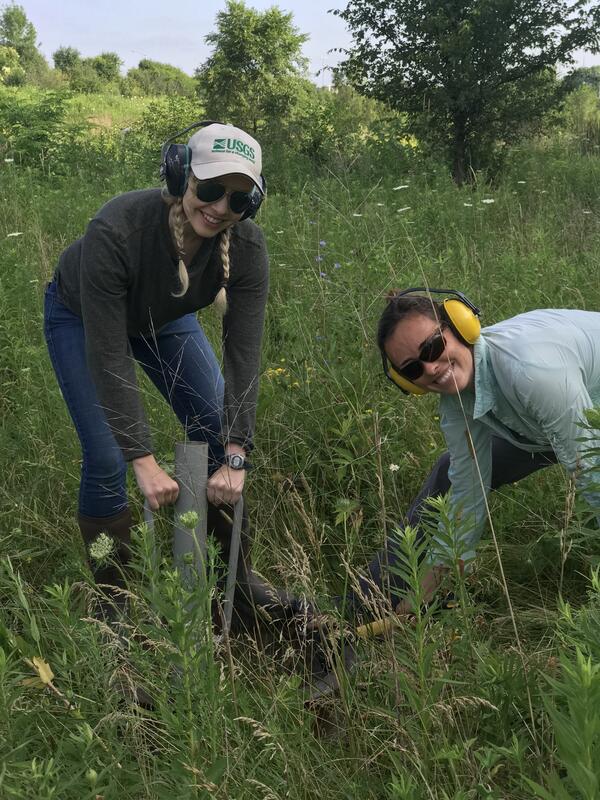
USGS scientists install a double ring infiltrometer
USGS scientists install a double ring infiltrometerIn this photo, USGS scientists Megan Haserodt (Hydrologist) and Jenelle Wempner (Student Intern) install a double ring infiltrometer along a recreated floodplain of Underwood Creek, a tributary to the Milwaukee River and Lake Michigan in Milwaukee, Wisconsin.

View of Half Dome from approximately 2,000’ up El Capitan (Mescalito)
View of Half Dome from approximately 2,000’ up El Capitan (Mescalito)Northeast Region Photo Contest, August 2019, People
View of Half Dome from approximately 2,000’ up El Capitan (Mescalito)
View of Half Dome from approximately 2,000’ up El Capitan (Mescalito)
View of Half Dome from approximately 2,000’ up El Capitan (Mescalito)Northeast Region Photo Contest, August 2019, People
View of Half Dome from approximately 2,000’ up El Capitan (Mescalito)

View South from Wolverine Glacier
View South from Wolverine Glacier
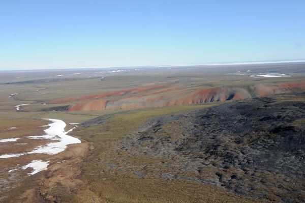
View to northeast from southwestern ANWR-1002 Area; ice in Camden Bay
View to northeast from southwestern ANWR-1002 Area; ice in Camden BayView to northeast from southwestern Arctic National Wildlife Refuge-1002 Area with ice in Camden Bay in distance. In foreground, red-weathering rocks are Hue Shale (oil-prone source rock with is present throughout 1002 Area) and dark gray rocks are Kemik Sandstone (lateral equivalent to Thomson sandstone, main reservoir in Pt. Thomson field).

View to the southeast from near the Canning River Delta
View to the southeast from near the Canning River DeltaView to the southeast from near the Canning River Delta. Visible in foreground are permafrost polygons cut by caribou trails.
Arctic National Wildlife Refuge
View to the southeast from near the Canning River Delta
View to the southeast from near the Canning River DeltaView to the southeast from near the Canning River Delta. Visible in foreground are permafrost polygons cut by caribou trails.
Arctic National Wildlife Refuge

Well head of Sourdough oil discovery on Alaska state lease
Well head of Sourdough oil discovery on Alaska state leaseWell head of Sourdough oil discovery on Alaska state lease less than one mile west of Arctic National Wildlife Refuge-1002 Area showing minimal disturbance of permafrost polygons.
Well head of Sourdough oil discovery on Alaska state lease
Well head of Sourdough oil discovery on Alaska state leaseWell head of Sourdough oil discovery on Alaska state lease less than one mile west of Arctic National Wildlife Refuge-1002 Area showing minimal disturbance of permafrost polygons.