
The Hammond Bay Biological Stationi. See our Locations page for more information.
Images
Explore our planet through photography and imagery, including climate change and water all the way back to the 1800s when the USGS was surveying the country by horse and buggy.
Filter Total Items: 21357

Hammond Bay Biological Station
The Hammond Bay Biological Stationi. See our Locations page for more information.

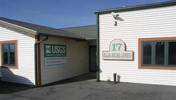
Lake Erie Biological Station
Arial view of the Lake Erie Biological Station. See our Locations page for more information.
Arial view of the Lake Erie Biological Station. See our Locations page for more information.

Maps in USGS Library in Reston
USGS Library has an expansive map collection with topographic maps, geologic maps, thematic maps, and more. The collection covers the United States, other countries around the world, and other planets.
By
USGS Library has an expansive map collection with topographic maps, geologic maps, thematic maps, and more. The collection covers the United States, other countries around the world, and other planets.
By

PWC and ATV for beach surveys
For typical beach surveys, USGS scientists drive an all-terrain vehicle (ATV) like the one shown here, equpped with precision GPS that collects location and elevation data. Driving along features such as high-water marks, and driving a grid pattern spaced by about 30 meters, enable the collection of a complete 3D representation of the beach surface.
For typical beach surveys, USGS scientists drive an all-terrain vehicle (ATV) like the one shown here, equpped with precision GPS that collects location and elevation data. Driving along features such as high-water marks, and driving a grid pattern spaced by about 30 meters, enable the collection of a complete 3D representation of the beach surface.

Reading Areas and Public Computers at USGS Library in Reston
Reading Areas and Public Computers at USGS Library in RestonUSGS Library locations offer collections and services to USGS staff and public researchers.
By
Reading Areas and Public Computers at USGS Library in Reston
Reading Areas and Public Computers at USGS Library in RestonUSGS Library locations offer collections and services to USGS staff and public researchers.
By

The chirp 512i on R/V Rainier
Science and ship crew on board NOAA research vessel Rainier prepare the Chirp 512i off south-central California.
Science and ship crew on board NOAA research vessel Rainier prepare the Chirp 512i off south-central California.
The Lake Ontario Biological Station
The Lake Erie Biological Station in Oswego, NY. Go to our Stations page to learn more.
The Lake Erie Biological Station in Oswego, NY. Go to our Stations page to learn more.
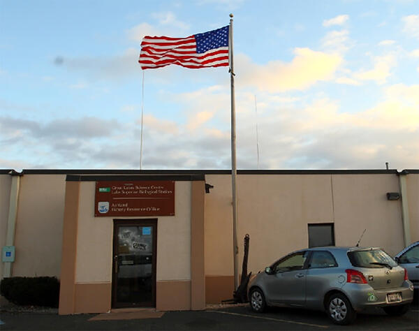
The Lake Superior Biological Station
The Lake Superior Biological Station. See our Location page for more information.
The Lake Superior Biological Station. See our Location page for more information.

Tunison Laboratory of Aquatic Science
The Tunison Laboratory of Aquatic Science. See our Locations page for more information.
The Tunison Laboratory of Aquatic Science. See our Locations page for more information.

USGS Bulletins at USGS Library in Reston
USGS Library has an extensive collection of USGS publications, including the bulletins pictured here.
By
USGS Library has an extensive collection of USGS publications, including the bulletins pictured here.
By

USGS Bulletins in USGS Library, Reston
Part of USGS Library collections is USGS publications, like the bulletins pictured here.
By
Part of USGS Library collections is USGS publications, like the bulletins pictured here.
By

Water Availability and Use Program Studies
Map of Water Availability and Use Program Studies from USGS Circular 1440 "Continuing Progress toward a national Assessment of Water Availability and Use."
Map of Water Availability and Use Program Studies from USGS Circular 1440 "Continuing Progress toward a national Assessment of Water Availability and Use."

Drainage area contributing to Big Creek below Lookout Creek, nr Apgar
Drainage area contributing to Big Creek below Lookout Creek, nr ApgarDrainage area contributing to Big Creek below Lookout Creek, near Apgar
Drainage area contributing to Big Creek below Lookout Creek, nr Apgar
Drainage area contributing to Big Creek below Lookout Creek, nr ApgarDrainage area contributing to Big Creek below Lookout Creek, near Apgar

Examining data aboard on boat
USGS scientist looking at laptop on boat
USGS scientist looking at laptop on boat

Hallowat Creek abv Kletomus Ck, nr Olney (12355342) streamgage
Hallowat Creek abv Kletomus Ck, nr Olney (12355342) streamgageHallowat Creek abv Kletomus Ck, nr Olney (12355342) streamgage
Hallowat Creek abv Kletomus Ck, nr Olney (12355342) streamgage
Hallowat Creek abv Kletomus Ck, nr Olney (12355342) streamgageHallowat Creek abv Kletomus Ck, nr Olney (12355342) streamgage

Hallowat Creek abv Kletomus Ck, nr Olney (12355342) streamgage
Hallowat Creek abv Kletomus Ck, nr Olney (12355342) streamgageHallowat Creek abv Kletomus Ck, nr Olney (12355342) streamgage
Hallowat Creek abv Kletomus Ck, nr Olney (12355342) streamgage
Hallowat Creek abv Kletomus Ck, nr Olney (12355342) streamgageHallowat Creek abv Kletomus Ck, nr Olney (12355342) streamgage

Hurricane Florence will erode or overwash beaches
The USGS Coastal Change Hazards Storm Team has forecast coast-wide levels of beach erosion, inundation and overwash due to Hurricane Florence's expected path and landgfall.
The USGS Coastal Change Hazards Storm Team has forecast coast-wide levels of beach erosion, inundation and overwash due to Hurricane Florence's expected path and landgfall.

Sea water levels to go up, stay up as Florence affects coast
Sea water levels to go up, stay up as Florence affects coastThe Coastal Change Hazards Storm Team has forecast changing water levels at specific locations over time.
Sea water levels to go up, stay up as Florence affects coast
Sea water levels to go up, stay up as Florence affects coastThe Coastal Change Hazards Storm Team has forecast changing water levels at specific locations over time.

Yellow Creek near Oak Grove, IN - downstream view
Yellow Creek near Oak Grove, IN - downstream view

Big Creek below Lookout Creek, near Apgar (site 12355347)
Big Creek below Lookout Creek, near Apgar (site 12355347)Big Creek below Lookout Creek, near Apgar (site 12355347)
Big Creek below Lookout Creek, near Apgar (site 12355347)
Big Creek below Lookout Creek, near Apgar (site 12355347)Big Creek below Lookout Creek, near Apgar (site 12355347)

USGS Scientists Get Ready for Hurricanes
A USGS hydrologic scientist installs a storm-tide sensor near the North Carolina coast as Hurricane Florence approaches.
A USGS hydrologic scientist installs a storm-tide sensor near the North Carolina coast as Hurricane Florence approaches.