
Raptors in the Trans Pecos, Texas Cooperative Fish and Wildlife Research Unit: State-Threatened, Riparian-Obligate Raptors in the Trans Pecos: Desert riparian systems are distinct narrow drainages that provide environmental conditions for vegetation dependent on permanent or ephemeral surface and subsurface water.
Images
Explore our planet through photography and imagery, including climate change and water all the way back to the 1800s when the USGS was surveying the country by horse and buggy.
Filter Total Items: 21351

Zone-tailed hawk in flight
Raptors in the Trans Pecos, Texas Cooperative Fish and Wildlife Research Unit: State-Threatened, Riparian-Obligate Raptors in the Trans Pecos: Desert riparian systems are distinct narrow drainages that provide environmental conditions for vegetation dependent on permanent or ephemeral surface and subsurface water.

helicopter overflight
Pu‘u ‘Ō‘ō on May 3, 2018, as viewed from the helicopter overflight. The crater floor is collapsed, and a thin plume escapes from the gaping crater. The west flank cracked on April 30th around 2:30 pm HST, and minor amounts of lava oozed out of the crack (line of steaming features) just before the plumbing system catastrophically failed.
Pu‘u ‘Ō‘ō on May 3, 2018, as viewed from the helicopter overflight. The crater floor is collapsed, and a thin plume escapes from the gaping crater. The west flank cracked on April 30th around 2:30 pm HST, and minor amounts of lava oozed out of the crack (line of steaming features) just before the plumbing system catastrophically failed.

lava temperatures were about 2000 degrees Fahrenheit
lava temperatures were about 2000 degrees FahrenheitWhen Kīlauea Volcano's lower East Rift Zone first erupted on May 3, 2018, lava temperatures were about 2000 degrees Fahrenheit. As the eruption progressed, with fresher magma feeding the fissures, the erupted lava became progressively hotter, resulting in more fluid and far-reaching lava flows (May 21 shown here).

School Branch at Maloney Road near Brownsburg IN - downstream view
School Branch at Maloney Road near Brownsburg IN - downstream viewSchool Branch at Maloney Road near Brownsburg IN - downstream view
School Branch at Maloney Road near Brownsburg IN - downstream view
School Branch at Maloney Road near Brownsburg IN - downstream viewSchool Branch at Maloney Road near Brownsburg IN - downstream view

School Branch at Maloney Road near Brownsburg IN - equipment in stream
School Branch at Maloney Road near Brownsburg IN - equipment in streamSchool Branch at Maloney Road near Brownsburg IN - equipment in stream
School Branch at Maloney Road near Brownsburg IN - equipment in stream
School Branch at Maloney Road near Brownsburg IN - equipment in streamSchool Branch at Maloney Road near Brownsburg IN - equipment in stream

Flooding in Soldier Pond, Maine
Flooding in Soldier Pond, Maine, following rainfall and snowmelt that led to high water levels in the Fish and St. John Rivers in April and May of 2018.
Flooding in Soldier Pond, Maine, following rainfall and snowmelt that led to high water levels in the Fish and St. John Rivers in April and May of 2018.

Joshua Tree, Edwards Air Force Base, Antelope Valley, CA
Joshua Tree, Edwards Air Force Base, Antelope Valley, CAJoshua trees dot the desert landscape on Edwards Air Force Base in Antelope Valley, CA.
Joshua Tree, Edwards Air Force Base, Antelope Valley, CA
Joshua Tree, Edwards Air Force Base, Antelope Valley, CAJoshua trees dot the desert landscape on Edwards Air Force Base in Antelope Valley, CA.

Rapid Deployment Gage in Soldier Pond, Maine
USGS field crews installed a temporary rapid deployment gage on May 2, 2018, at Soldier Pond in the Fish River to monitor flooding near Fort Kent in Maine.
USGS field crews installed a temporary rapid deployment gage on May 2, 2018, at Soldier Pond in the Fish River to monitor flooding near Fort Kent in Maine.

Stratigraphic contact marking 1964 uplift of Montague Island, Alaska
Stratigraphic contact marking 1964 uplift of Montague Island, AlaskaStratigraphic contact marking uplift of Montague Island, caused by slip on the Patton Bay fault system during the 1964 M9.2 Great ALaska Earthquake.
Stratigraphic contact marking 1964 uplift of Montague Island, Alaska
Stratigraphic contact marking 1964 uplift of Montague Island, AlaskaStratigraphic contact marking uplift of Montague Island, caused by slip on the Patton Bay fault system during the 1964 M9.2 Great ALaska Earthquake.

Alkalinity Sample Analysis to Ensure Accuracy of Field Results
Alkalinity Sample Analysis to Ensure Accuracy of Field Results

As of this afternoon (May 1), the eruption at the summit of Kīlauea...
As of this afternoon (May 1), the eruption at the summit of Kīlauea...As of this afternoon (May 1), the eruption at the summit of Kīlauea has apparently not been affected by the collapse of Pu‘u ‘Ō‘ō or intrusion of magma along the volcano's Lower East Rift Zone.

Bear Lake Mixing
NASA image of Bear Lake with beautiful swirls in blue water showing mixing
NASA image of Bear Lake with beautiful swirls in blue water showing mixing

Bird's eye view of Woods Hole's Quissett Campus, MA
Bird's eye view of Woods Hole's Quissett Campus, MAView from a drone! Aerial view of Woods Hole Coastal and Marine Science Center's Quissett Campus.
Bird's eye view of Woods Hole's Quissett Campus, MA
Bird's eye view of Woods Hole's Quissett Campus, MAView from a drone! Aerial view of Woods Hole Coastal and Marine Science Center's Quissett Campus.

Collaborating with university students
The Southwest Biological Science Center loves working with students. Here, a group of undergraduates from Northern Arizona University help RAMPS define the reasons why ecosystem restoration is important for human health and the economy. Follow the link to learn more about RAMPS.
The Southwest Biological Science Center loves working with students. Here, a group of undergraduates from Northern Arizona University help RAMPS define the reasons why ecosystem restoration is important for human health and the economy. Follow the link to learn more about RAMPS.
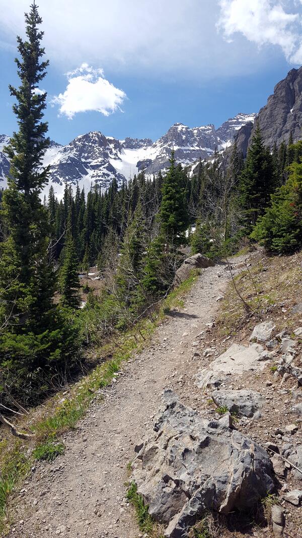
NDTc - San Juan Mountains in southwestern Colorado
NDTc - San Juan Mountains in southwestern ColoradoA scenic trail leading to the Blue Lakes located in southwest Colorado in the Mount Sneffels Wilderness Area.
NDTc - San Juan Mountains in southwestern Colorado
NDTc - San Juan Mountains in southwestern ColoradoA scenic trail leading to the Blue Lakes located in southwest Colorado in the Mount Sneffels Wilderness Area.

Over 500 earthquakes were located by the USGS Hawaiian Volcano Observa
Over 500 earthquakes were located by the USGS Hawaiian Volcano ObservaOver 500 earthquakes were located by the USGS Hawaiian Volcano Observatory (HVO) between noon Friday and noon Saturday, May 4-5, 2018. A magnitude-6.9 earthquake at 12:32 p.m. HST on Friday was preceded by two foreshocks with magnitudes of 5.4 and 4.4 at 11:32 a.m.

Rattlesnake Fire, Arizona
The 2018 fire season is already active in the western United States. One of the larger wildfires so far is the Rattlesnake Fire.
The 2018 fire season is already active in the western United States. One of the larger wildfires so far is the Rattlesnake Fire.

Wildfire mitigation after image
This photo was taken just after wildfire mitigation efforts. The WiRe (Wildfire Research Team) conducts research on these mitigation efforts and other components of wildfires and communities. More can be learned on their website.
This photo was taken just after wildfire mitigation efforts. The WiRe (Wildfire Research Team) conducts research on these mitigation efforts and other components of wildfires and communities. More can be learned on their website.

Wildfire mitigation before image
This photo was taken just before wildfire mitigation efforts. The WiRe (Wildfire Research Team) conducts research on these mitigation efforts and other components of wildfires and communities. More can be learned on their website.
This photo was taken just before wildfire mitigation efforts. The WiRe (Wildfire Research Team) conducts research on these mitigation efforts and other components of wildfires and communities. More can be learned on their website.

Kīlauea summit lava lake level drops with deflation
Kīlauea summit lava lake level drops with deflationJust before 10:00 a.m. today (Monday, April 30), a break in the weather allowed HVO's webcam to capture this image of the lava lake within Halema‘uma‘u at the summit of Kīlauea. Following multiple overflows of the lava lake last week, the lake level dropped over the weekend in concert with the switch to summit deflation.