
Portaging boat around Flaming Gorge Dam
Images
Explore our planet through photography and imagery, including climate change and water all the way back to the 1800s when the USGS was surveying the country by horse and buggy.
Filter Total Items: 21343

Spillway Boat Launch at Flaming Gorge Dam (UT)

View of Sheep Canyon
Day 5 scenic view of Sheep Canyon
Day 5 scenic view of Sheep Canyon

Yellow Warbler
Yellow Warbler in Grass along Green River


Flaming Gorge NRA
Day 4 first sighting of Flaming Gorge, Utah
Day 4 first sighting of Flaming Gorge, Utah

Flaming Gorge NRA
Day 4 first sigting of Flaming Gorge, Utah
Day 4 first sigting of Flaming Gorge, Utah

Flaming Gorge rock formation panorama
Panorama photo of a rock formation as SCREE enters Flaming Gorge (May 27th, 2019).
Panorama photo of a rock formation as SCREE enters Flaming Gorge (May 27th, 2019).

Historical wet photography
Day 5 wet photo of Flaming Gorge Dam
Day 5 wet photo of Flaming Gorge Dam

Overlooking SCREE's fourth camp
Overlooking SCREE's fourth camp, on the shore of Flaming Gorge Reservoir just above the Flaming Gorge Dam. The five SCREE boats as well as University of Wyoming's research vessel can be seen beached on a narrow band of sand and rocks just below a steep forested hillside. (May 27th, 2019.)
Overlooking SCREE's fourth camp, on the shore of Flaming Gorge Reservoir just above the Flaming Gorge Dam. The five SCREE boats as well as University of Wyoming's research vessel can be seen beached on a narrow band of sand and rocks just below a steep forested hillside. (May 27th, 2019.)

Paper Powell
Day 4 USGS Rusty Sherman and Janis LeMaster

Rafts at campground
Day 4 rafts at campground


Beach on Flaming Gorge Reservoir
On the expedition, USGS scientists are tasked with collecting sediment samples from the beaches where we camp. The goal of the study is to examine the presence of microplastics along the river. There are strict protocols on the condition of the sediment we collect, so sometimes we have to travel far from camp in order to find suitable sediment.
On the expedition, USGS scientists are tasked with collecting sediment samples from the beaches where we camp. The goal of the study is to examine the presence of microplastics along the river. There are strict protocols on the condition of the sediment we collect, so sometimes we have to travel far from camp in order to find suitable sediment.

Bike path in Falmouth, MA
Bike path skirting cobbled beaches of Falmouth, Massachusetts.
Bike path skirting cobbled beaches of Falmouth, Massachusetts.

Overlooking SCREE's third camp
Overlooking SCREE's third camp, on the shore of Flaming Gorge Reservoir. In addition to the 5 SCREE boats, the University of Wyoming research vessel that towed the Expedition down 70 miles of man-made lake is beached for the evening. Tents have been set up for the night, and dinner is being prepared (May 26th, 2019).
Overlooking SCREE's third camp, on the shore of Flaming Gorge Reservoir. In addition to the 5 SCREE boats, the University of Wyoming research vessel that towed the Expedition down 70 miles of man-made lake is beached for the evening. Tents have been set up for the night, and dinner is being prepared (May 26th, 2019).

Paper Powell with Sagebrush desert in background
Paper Powell! Behind him is a sagebrush steppe environment. Sagebrush steppe is a type of ecosystem strongly characterized by the presence of sagebrush species, particularly Big Sagebrush, or Artemisia tridentata. Sagebrush steppe today is threatened by many factors, including the presence of invasive species.
Paper Powell! Behind him is a sagebrush steppe environment. Sagebrush steppe is a type of ecosystem strongly characterized by the presence of sagebrush species, particularly Big Sagebrush, or Artemisia tridentata. Sagebrush steppe today is threatened by many factors, including the presence of invasive species.

Reflections
Day 3 mirror reflections of landscape on water

Reflections
Day 3 mirror reflections of landscape on water

Reflections
Day 3 mirror reflections of landscape on water
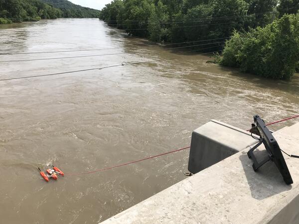
streamflow measurement from State Highway 20 bridge
streamflow measurement from State Highway 20 bridgeA direct streamflow measurement from the State Highway 20 bridge, looking downstream on the Verdigris River near Claremore, Oklahoma, near U.S. Geological Survey streamgage 07176000.
U.S. Geological Survey Open-File Report 2020–1090