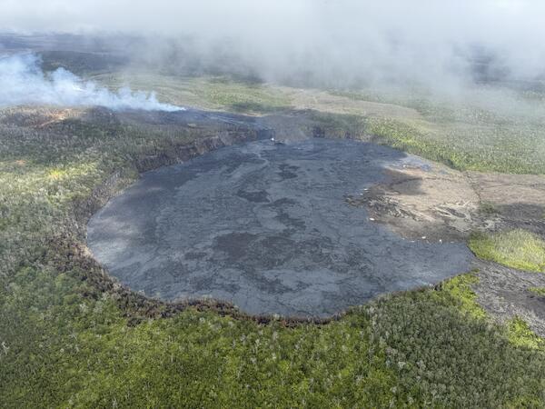
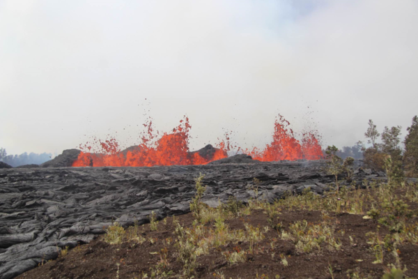
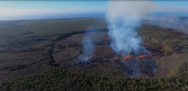
On September 19, 2024, USGS-Hawaiian Volcano Observatory geologists landed near the Kīlauea middle East Rift Zone eruption site, where they viewed lava flowing through a channel more than 50 meters (about 164 feet) wide.
Videos
The USGS is a science organization that provides impartial information on the health of our ecosystems and environment, the natural hazards that threaten us, the natural resources we rely on, the impacts of climate and land-use change, and the core science systems that help us provide timely, relevant, and useable information.
 September 19, 2024—New lava flows on the middle East Rift Zone of Kīlauea
On September 19, 2024, USGS-Hawaiian Volcano Observatory geologists landed near the Kīlauea middle East Rift Zone eruption site, where they viewed lava flowing through a channel more than 50 meters (about 164 feet) wide.
 September 20, 2024 —Kīlauea middle East Rift Zone eruption summary
On the night of September 15, USGS Hawaiian Volcano Observatory geophysical data indicated that an eruption could be occurring a remote area of Kīlauea’s middle East Rift Zone, within Hawaiʻi Volcanoes National Park.
On the night of September 15, USGS Hawaiian Volcano Observatory geophysical data indicated that an eruption could be occurring a remote area of Kīlauea’s middle East Rift Zone, within Hawaiʻi Volcanoes National Park.
 September 20, 2024—Kīlauea middle East Rift Zone eruption overflight and ground views
USGS Hawaiian Volcano Observatory field monitoring crews captured these videos during their visit to Kīlauea middle East Rift Zone eruption site the morning of September 20, 2024. They reported minor spattering and small fountains at one end of the vent at 8:30 a.m. HST. By 10 a.m.
USGS Hawaiian Volcano Observatory field monitoring crews captured these videos during their visit to Kīlauea middle East Rift Zone eruption site the morning of September 20, 2024. They reported minor spattering and small fountains at one end of the vent at 8:30 a.m. HST. By 10 a.m.
 September 19, 2024 — Kīlauea middle East Rift Zone eruption overflight
USGS Hawaiian Volcano Observatory geologists conducted a reconnaissance overflight of the eruption near Nāpau Crater on the middle East Rift Zone of Kīlauea. They observed lava cascading over the rim of the crater from a channel more than 50 meters (about 164 feet) wide.
USGS Hawaiian Volcano Observatory geologists conducted a reconnaissance overflight of the eruption near Nāpau Crater on the middle East Rift Zone of Kīlauea. They observed lava cascading over the rim of the crater from a channel more than 50 meters (about 164 feet) wide.
 September 19, 2024 —Kīlauea lava fountains erupting
On September 19, USGS Hawaiian Volcano Observatory geologists were able to capture this video of the fissure vent eruption west of Nāpau Crater on the middle East Rift Zone of Kīlauea. They observed a 150-m-long (nearly 500 feet) fissure west of the crater erupting lava in a curtain of lava 10-20 meters (33-66 feet) high.
On September 19, USGS Hawaiian Volcano Observatory geologists were able to capture this video of the fissure vent eruption west of Nāpau Crater on the middle East Rift Zone of Kīlauea. They observed a 150-m-long (nearly 500 feet) fissure west of the crater erupting lava in a curtain of lava 10-20 meters (33-66 feet) high.
 September 17, 2024 —Kīlauea middle East Rift Zone eruption overflight
Kīlauea volcano is erupting in Hawai’i Volcanoes National Park from a new fissure vent that opened within Nāpau Crater this morning, September 17, between 4:00 and 5:00 AM HST. The eruption is occurring within a closed and remote area of Hawaiʻi Volcanoes National Park.
Kīlauea volcano is erupting in Hawai’i Volcanoes National Park from a new fissure vent that opened within Nāpau Crater this morning, September 17, between 4:00 and 5:00 AM HST. The eruption is occurring within a closed and remote area of Hawaiʻi Volcanoes National Park.
 September 17, 2024 —Kīlauea middle East Rift Zone eruption sampling
USGS Hawaiian Volcano Observatory geologists collected a sample of the middle East Rift Zone Kīlauea eruption in Nāpau Crater, within a closed area Hawaiʻi Volcanoes National Park. Geologists put molten lava into a metal bucket and rapidly quench it with water.
USGS Hawaiian Volcano Observatory geologists collected a sample of the middle East Rift Zone Kīlauea eruption in Nāpau Crater, within a closed area Hawaiʻi Volcanoes National Park. Geologists put molten lava into a metal bucket and rapidly quench it with water.
 September 16, 2024 — Overflight video of eruption site near Nāpau Crater, Kīlauea
A brief, small eruption occurred on the middle East Rift Zone of Kīlauea late on September 15. The eruption produced two small pads of lava just west of Nāpau Crater, which is west (uprift) of the former Pu‘u‘ō‘ō eruption site.
A brief, small eruption occurred on the middle East Rift Zone of Kīlauea late on September 15. The eruption produced two small pads of lava just west of Nāpau Crater, which is west (uprift) of the former Pu‘u‘ō‘ō eruption site.
 September 16, 2024 —Kīlauea middle East Rift Zone eruption overflight
This video, taken during a Hawaiian Volcano Observatory morning overflight of Kīlaueaʻs middle East Rift Zone on September 16, 2024, shows new lava flows erupted over about an hour during the evening on September 15, 2024.
This video, taken during a Hawaiian Volcano Observatory morning overflight of Kīlaueaʻs middle East Rift Zone on September 16, 2024, shows new lava flows erupted over about an hour during the evening on September 15, 2024.
 September 16, 2024—Brief eruption near Nāpau Crater on Kīlauea Middle East Rift Zone
During a USGS Hawaiian Volcano Observatory overflight at approximately 10:30 a.m. HST on September 16, geologists observed freshly erupted lava west of Nāpau Crater on the remote middle East Rift Zone of Kīlauea, within Hawaiʻi Volcanoes National Park. This eruption likely occurred between approximately 9–10 p.m. HST on September 15.
During a USGS Hawaiian Volcano Observatory overflight at approximately 10:30 a.m. HST on September 16, geologists observed freshly erupted lava west of Nāpau Crater on the remote middle East Rift Zone of Kīlauea, within Hawaiʻi Volcanoes National Park. This eruption likely occurred between approximately 9–10 p.m. HST on September 15.
 Is there oil in Yellowstone? (Yellowstone Monthly Update - September 2024)
Is it true that there's oil in Yellowstone? Watch this month's Yellowstone Monthly update and find out.
Is it true that there's oil in Yellowstone? Watch this month's Yellowstone Monthly update and find out.
 Landsat Captures Mexico's Trending Drought (Image of the Week)
Prolonged drought has lowered water levels in Laguna Bustillos in Chihuahua State, Mexico, killing thousands of fish.
Prolonged drought has lowered water levels in Laguna Bustillos in Chihuahua State, Mexico, killing thousands of fish.
 Biscuit Basin Update; 65th Anniversary — M7.3 Hebgen Lake Quake (Yellowstone Monthly Update - Aug 2024)
Biscuit Basin Update; 65th Anniversary — M7.3 Hebgen Lake Quake (Yellowstone Monthly Update - Aug 2024)
linkIn this month's video, we update you on the Biscuit Basin explosion on July 23, 2024, and discuss the 65th anniversary of the M7.3 Hegben Lake earthquake.
Biscuit Basin Update; 65th Anniversary — M7.3 Hebgen Lake Quake (Yellowstone Monthly Update - Aug 2024)
linkIn this month's video, we update you on the Biscuit Basin explosion on July 23, 2024, and discuss the 65th anniversary of the M7.3 Hegben Lake earthquake.
 Swimming Pools at Yellowstone? (Yellowstone Monthly Update - June 2024)
Up until the 1950s, visitors to the Old Faithful area could take a dip. Not at a geyser, but in a real swimming pool. The full story is in this month’s video update.
Up until the 1950s, visitors to the Old Faithful area could take a dip. Not at a geyser, but in a real swimming pool. The full story is in this month’s video update.
 Aerial video of the Southwest Rift Zone eruption of Kīlauea
Aerial video of the Southwest Rift Zone eruption of Kīlauea, viewed during an overflight at approximately 6 a.m. on June 3, 2024. USGS video.
Aerial video of the Southwest Rift Zone eruption of Kīlauea, viewed during an overflight at approximately 6 a.m. on June 3, 2024. USGS video.
During an overflight at approximately 6 a.m., USGS Hawaiian Volcano Observatory geologists observed the fissures system that opened on the upper portion of the Southwest Rift Zone early this morning. Approximately half a mile (about 1 km) in length, only the southwest portion of the system was active by daylight.
During an overflight at approximately 6 a.m., USGS Hawaiian Volcano Observatory geologists observed the fissures system that opened on the upper portion of the Southwest Rift Zone early this morning. Approximately half a mile (about 1 km) in length, only the southwest portion of the system was active by daylight.
 100 years ago at Kīlauea: The 1924 explosive eruption described by Thomas Jaggar
This two-minute video summarizes the 1924 explosive eruption at the summit of Kīlauea, which occurred 100 years ago this year. The video is narrated by Thomas Jaggar, who founded the Hawaiian Volcano Observatory in 1912. His description of the 1924 eruption was recorded in 1951 by Hawaiʻi Volcanoes National Park.
This two-minute video summarizes the 1924 explosive eruption at the summit of Kīlauea, which occurred 100 years ago this year. The video is narrated by Thomas Jaggar, who founded the Hawaiian Volcano Observatory in 1912. His description of the 1924 eruption was recorded in 1951 by Hawaiʻi Volcanoes National Park.
 UAS Operations for Carbon Sequestration Research on Public Lands near Moab, Utah in May 2023
In support of U.S. Geological Survey (USGS) Southwest Biological Science Center research, the USGS National Uncrewed Systems Office (NUSO) conducted uncrewed aircraft systems (UAS) remote sensing flights near Moab, Utah in May 2023 for multi-scale carbon sequestration research on public lands.
In support of U.S. Geological Survey (USGS) Southwest Biological Science Center research, the USGS National Uncrewed Systems Office (NUSO) conducted uncrewed aircraft systems (UAS) remote sensing flights near Moab, Utah in May 2023 for multi-scale carbon sequestration research on public lands.
 Mount St. Helens VS Yellowstone (Yellowstone Monthly Update - May 2024)
Mount St. Helens and Yellowstone are two of the most well-known volcanoes in the United States. They have some pretty obvious differences, but they have some similarities as well. So, just how similar are Mount St. Helens and Yellowstone?
Mount St. Helens and Yellowstone are two of the most well-known volcanoes in the United States. They have some pretty obvious differences, but they have some similarities as well. So, just how similar are Mount St. Helens and Yellowstone?
 Image of the Week: A Warm February in Northern Minnesota
Like many lakes in northern Minnesota, Mille Lacs near Brainerd experienced an uncommonly warm winter this year, with lower than average snowfall. Natural color Landsat images from the past ten Februarys reveal a stark change in 2024.
Like many lakes in northern Minnesota, Mille Lacs near Brainerd experienced an uncommonly warm winter this year, with lower than average snowfall. Natural color Landsat images from the past ten Februarys reveal a stark change in 2024.
 Human-Built Natural Infrastructure in Dryland Streams — Lessons from the "20-Year Crew"
On April 16^th^, 2024, the USGS hosted notable restoration practitioners from the Sky Island Restoration Collaborative (SIRC) at the National Conference on Ecosystem Restoration, in Albuquerque, NM, in a session about low-cost, low-tech, nature-based solutions, that can help people mitigate and adapt to climate changes.
On April 16^th^, 2024, the USGS hosted notable restoration practitioners from the Sky Island Restoration Collaborative (SIRC) at the National Conference on Ecosystem Restoration, in Albuquerque, NM, in a session about low-cost, low-tech, nature-based solutions, that can help people mitigate and adapt to climate changes.


