
A view from the helicopter of the lava pond in the east collapse pit within Pu‘u ‘Ō‘ō crater. The pit enlarged substantially last week as the lava pond dropped during a deflation phase. Though the lava level has risen since that time, it remains deep within the collapse pit.
Images
Volcano Hazard Program images.
Filter Total Items: 6275

A view from the helicopter within Pu‘u ‘Ō‘ō.
A view from the helicopter of the lava pond in the east collapse pit within Pu‘u ‘Ō‘ō crater. The pit enlarged substantially last week as the lava pond dropped during a deflation phase. Though the lava level has risen since that time, it remains deep within the collapse pit.

Continued flow activity on coastal plain but little forward progress
Continued flow activity on coastal plain but little forward progressSurface flows remain active on the pali and coastal plain, but have not made significant progress towards the ocean. On today's field visit, the closest flows to the ocean were about 2 km (1.2 miles) from the water. This image shows a pāhoehoe breakout at the flow front, with a rigid ropy section of crust being carried forward by the flowing lava beneath it.

Technology today: Geologist working at a Global Positioning System...
Technology today: Geologist working at a Global Positioning System...Technology today: Geologist working at a Global Positioning System station on Mount St. Helens, Washington.
Technology today: Geologist working at a Global Positioning System...
Technology today: Geologist working at a Global Positioning System...Technology today: Geologist working at a Global Positioning System station on Mount St. Helens, Washington.

Satellite image shows active surface flows
This false-color image was captured on August 19 by NASA's Earth Observing 1 satellite using the Advanced Land Imager sensor. The image consists of several near-infrared and shortwave infrared channels combined in such a way as to mimic those colors expected by the human eye, with vegetation green, lava flow fields black and active surface lava flows as red.
This false-color image was captured on August 19 by NASA's Earth Observing 1 satellite using the Advanced Land Imager sensor. The image consists of several near-infrared and shortwave infrared channels combined in such a way as to mimic those colors expected by the human eye, with vegetation green, lava flow fields black and active surface lava flows as red.

Hawaiian volcanoes are in the spotlight
A conference this week in Waikōloa will examine how Hawaiian volcanoes work, from their source deep within the Earth to the eruption of gas and lava at the surface. The conference is hosted by the American Geophysical Union and organized by scientists from the Hawaiian Volcano Observatory and the University of Hawai‘i at Hilo.
A conference this week in Waikōloa will examine how Hawaiian volcanoes work, from their source deep within the Earth to the eruption of gas and lava at the surface. The conference is hosted by the American Geophysical Union and organized by scientists from the Hawaiian Volcano Observatory and the University of Hawai‘i at Hilo.

Mapping the North Fork Toutle River using a terrestrial laser scann...
Mapping the North Fork Toutle River using a terrestrial laser scann...The USGS, in collaboration with UNAVCO and the University of Colorado, uses these data to measure channel erosion and deposition in the reach.
Mapping the North Fork Toutle River using a terrestrial laser scann...
Mapping the North Fork Toutle River using a terrestrial laser scann...The USGS, in collaboration with UNAVCO and the University of Colorado, uses these data to measure channel erosion and deposition in the reach.

220 kV transmission lines running adjacent to Tongariro Volcano, Ne...
220 kV transmission lines running adjacent to Tongariro Volcano, Ne...220 kV transmission lines running adjacent to Tongariro Volcano, New Zealand, two days after the 6 August 2012 Te MÄri crater eruption.
220 kV transmission lines running adjacent to Tongariro Volcano, Ne...
220 kV transmission lines running adjacent to Tongariro Volcano, Ne...220 kV transmission lines running adjacent to Tongariro Volcano, New Zealand, two days after the 6 August 2012 Te MÄri crater eruption.

Kīlauea showing familiar pattern—or is it?
Hawaiian Volcano Observatory's Recent Earthquakes Web page from Tuesday, July 31, with earthquake shown as colored circles, according to their times of occurrence.
Hawaiian Volcano Observatory's Recent Earthquakes Web page from Tuesday, July 31, with earthquake shown as colored circles, according to their times of occurrence.

Examining layers of rock and ash in pyroclastic flow strata helps s...
Examining layers of rock and ash in pyroclastic flow strata helps s...Photo taken north of Mount St. Helens; view is to the south.
Examining layers of rock and ash in pyroclastic flow strata helps s...
Examining layers of rock and ash in pyroclastic flow strata helps s...Photo taken north of Mount St. Helens; view is to the south.

Small, scattered breakouts on flow field
This image is a composite of a thermal image and a normal photograph, showing the coastal plain and pali. Red areas are warm portions of the flow field that were active in the past weeks or months, while yellow and white areas are areas of active breakouts.
This image is a composite of a thermal image and a normal photograph, showing the coastal plain and pali. Red areas are warm portions of the flow field that were active in the past weeks or months, while yellow and white areas are areas of active breakouts.

The lava pond in the NE portion of Pu‘u ‘Ō‘ō remains active, though...
The lava pond in the NE portion of Pu‘u ‘Ō‘ō remains active, though...The lava pond in the northeast portion of Pu‘u ‘Ō‘ō crater remains active, though the level of lava was low in the pit today. Over this past weekend, a small collapse of the rim enlarged the pit slightly. The lava pond is about 30 meters (100 feet) wide.

Andesite lava flow of Kerr Notch (near Sun Creek) developed columna...
Andesite lava flow of Kerr Notch (near Sun Creek) developed columna...Andesite lava flow of Kerr Notch (near Sun Creek) developed columnar joints as it cooled after it was deposited, Crater Lake, Oregon.
Andesite lava flow of Kerr Notch (near Sun Creek) developed columna...
Andesite lava flow of Kerr Notch (near Sun Creek) developed columna...Andesite lava flow of Kerr Notch (near Sun Creek) developed columnar joints as it cooled after it was deposited, Crater Lake, Oregon.

Kīlauea's July 1974 summit eruption
Lava fountains, occasionally surging to heights of 45-55 m (150-180 ft), erupted south and north of Keanakāko‘i Crater (top and middle fissures, respectively) and on the floor of Kīlauea Caldera (foreground fissure) in a spectacular summit eruption on July 19, 1974.
Lava fountains, occasionally surging to heights of 45-55 m (150-180 ft), erupted south and north of Keanakāko‘i Crater (top and middle fissures, respectively) and on the floor of Kīlauea Caldera (foreground fissure) in a spectacular summit eruption on July 19, 1974.
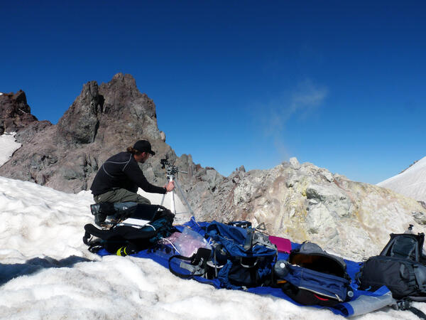
USGS geologist uses a UV spectrometer to detect gases from a fumarole
USGS geologist uses a UV spectrometer to detect gases from a fumaroleUSGS geologist uses a UV spectrometer to detect gases from fumarole at Crater Rock, Mount Hood.
USGS geologist uses a UV spectrometer to detect gases from a fumarole
USGS geologist uses a UV spectrometer to detect gases from a fumaroleUSGS geologist uses a UV spectrometer to detect gases from fumarole at Crater Rock, Mount Hood.

Exploring Mount Rainier: living near a volcano provides an opportu...
Exploring Mount Rainier: living near a volcano provides an opportu...Exploring Mount Rainier: living near a volcano provides an opportunity for field-based learning.
Exploring Mount Rainier: living near a volcano provides an opportu...
Exploring Mount Rainier: living near a volcano provides an opportu...Exploring Mount Rainier: living near a volcano provides an opportunity for field-based learning.

Surface flows on pali and coastal plain; small lava lake in Pu‘u ‘Ō‘ō
Surface flows on pali and coastal plain; small lava lake in Pu‘u ‘Ō‘ōSurface flows remain active on the coastal plain, but have retreated inland compared to their position last week. The active front is now about 1.3 km (0.8 miles) from the ocean.

In addition to active flows on the coastal plain, lava flows were a...
In addition to active flows on the coastal plain, lava flows were a...In addition to the active flows on the coastal plain, lava flows were also active on the pali and at the base of the pali. Pu‘u ‘Ō‘ō and the Halema‘uma‘u plume are visible near the top of the image.

Pu‘u ‘Ō‘ō — Lava Lake
The lava lake on the northeastern edge of the Pu‘u ‘Ō‘ō crater floor is about 30 m (100 ft) across. It's level rises and falls with changes in pressure in the magma storage body beneath Pu‘u ‘Ō‘ō. Today, the lava lake was at a relatively low level, compared to its condition over the last few months.
The lava lake on the northeastern edge of the Pu‘u ‘Ō‘ō crater floor is about 30 m (100 ft) across. It's level rises and falls with changes in pressure in the magma storage body beneath Pu‘u ‘Ō‘ō. Today, the lava lake was at a relatively low level, compared to its condition over the last few months.

Several openings on the floor of the Pu‘u ‘Ō‘ō
Several openings on the floor of the Pu‘u ‘Ō‘ō crater and along the Peace Day flow tube system continue to degas profusely. The only visible lava, however, is the small lava lake confined to a pit on the northeastern side of the crater floor. The lava lake has been present for the last several months.
Several openings on the floor of the Pu‘u ‘Ō‘ō crater and along the Peace Day flow tube system continue to degas profusely. The only visible lava, however, is the small lava lake confined to a pit on the northeastern side of the crater floor. The lava lake has been present for the last several months.

Water depth measurements at Spirit Lake, Mount St. Helens, using ac...
Water depth measurements at Spirit Lake, Mount St. Helens, using ac...Back at the USGS Cascades Volcano Observatory office, these data are merged with airborne LiDAR data to calculate lake volume.
Water depth measurements at Spirit Lake, Mount St. Helens, using ac...
Water depth measurements at Spirit Lake, Mount St. Helens, using ac...Back at the USGS Cascades Volcano Observatory office, these data are merged with airborne LiDAR data to calculate lake volume.

Kīlauea's summit and rift zones are well connected
Kīlauea's summit and rift zones are well connectedA view of the lava lake within the Halema‘uma‘u Overlook vent on an unusually clear day (May 16, 2012) with the Jaggar Museum and the HVO building in the distance.
Kīlauea's summit and rift zones are well connected
Kīlauea's summit and rift zones are well connectedA view of the lava lake within the Halema‘uma‘u Overlook vent on an unusually clear day (May 16, 2012) with the Jaggar Museum and the HVO building in the distance.