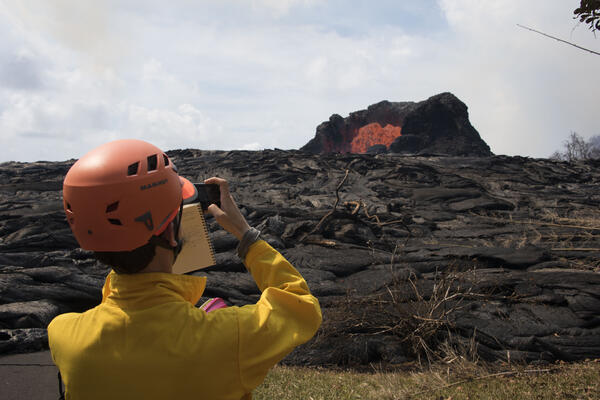
Aerial view of the ocean-entry areas at about 12:30 p.m. HST. Lava flowing into the ocean diminished overnight and this morning (note lack of obvious plume at the entry areas). View is toward the northwest.
Images
Volcano Hazard Program images.
Aerial view of the ocean-entry areas at about 12:30 p.m. HST. Lava flowing into the ocean diminished overnight and this morning (note lack of obvious plume at the entry areas). View is toward the northwest.
Kīlauea Volcano — Enlargement of Summit Eruptive Event
Kīlauea Volcano — Enlargement of Summit Eruptive EventThis image shows radar data acquired by the European Space Agency's Sentinel-1 satellite over Kīlauea Volcano on May 19 at 6:30 PM HST (left) compared to May 25 at 6:30 PM HST (right). The satellite transmits a radar signal toward the surface and measures the strength of the return, with bright areas indicating a strong return and dark areas a weak return.
Kīlauea Volcano — Aerial of Eastern-Most Fissure Complex
Kīlauea Volcano — Aerial of Eastern-Most Fissure ComplexAerial view of the eastern-most end of the fissure complex (top right) and active lava channels and inactive flows south of the fissures (toward left side of photo) at about 12:30 p.m. HST; the ocean is out of view left side of photo. In this view, fissure 22 in top right is supplying most of the lava to the active channel.
Fountaining fissure documentation at the Kilauea eruption
Fountaining fissure documentation at the Kilauea eruptionUSGS scientist in the Lower East Rift Zone documenting the spectacular ~50 m tall fissure 7 lava fountain to the east which had lit up the sky in a red hue.
Fountaining fissure documentation at the Kilauea eruption
Fountaining fissure documentation at the Kilauea eruptionUSGS scientist in the Lower East Rift Zone documenting the spectacular ~50 m tall fissure 7 lava fountain to the east which had lit up the sky in a red hue.
This ‘a‘ā flow, erupted from fissures 7 and 21, was approximately 3–4 meters (yards) high at the flow front and slowly advancing to the northeast in the Leilani Estates subdivision around 10:30 a.m. HST today.
An aerial view, looking west, of the two active ocean entries on Kīlauea Volcano's lower East Rift Zone. The large white plume (foreground) is the eastern ocean entry; the weaker, western plume can be seen in the distance.
This ‘A‘ā flow, erupted from fissures 7 and 21, was approximately 3...
This ‘A‘ā flow, erupted from fissures 7 and 21, was approximately 3...This ‘A‘ā flow, erupted from fissures 7 and 21, was approximately 3-4 meters (yards) high at the flow front and slowly advancing to the northeast in the Leilani Estates subdivision around 10:30 a.m. HST today.
fissure 22 looking toward the south. Fissure 22 continues to erupt ...
fissure 22 looking toward the south. Fissure 22 continues to erupt ...Aerial view of fissure 22 looking toward the south. Fissure 22 continues to erupt lava that is flowing southeast to the coast and entering the ocean.
fissure 22 looking toward the south. Fissure 22 continues to erupt ...
fissure 22 looking toward the south. Fissure 22 continues to erupt ...Aerial view of fissure 22 looking toward the south. Fissure 22 continues to erupt lava that is flowing southeast to the coast and entering the ocean.
Wendy Stovall next to lava flow field with Kīlauea fissure 8 eruption in 2018 lower East Rift Zone
Wendy Stovall next to lava flow field with Kīlauea fissure 8 eruption in 2018 lower East Rift ZoneWendy Stovall standing in Leilani Estates subdivision during a geologic field work monitoring campaign of the 2018 eruption of Kīlauea volcano. Photo by M. Lubeck.
This thermal map shows the fissure system and lava flows as of 12:15 pm on Friday, May 25. Two channelized lava flows are reaching the ocean. In addition, a lava flow is active in Leilani Estates subdivision, near Fissure 7.
An aerial view, looking west, of the two active ocean entries on Kīlauea Volcano's lower East Rift Zone. The large white plume (foreground) is the eastern ocean entry; the weaker, western plume can be seen in the distance.
Aerial view of the active ocean entries at Kīlauea Volcano's lower East Rift Zone captured during this morning's HVO overflight. An ongoing hazard at the ocean entries is laze.
Fissures 6 (left) and 13 (right), with lava flows merging into one channel that flows into the ocean at the western-most entry. Note plume in distance at the ocean entries (top left). Photo is from an overflight at mid day.
Kīlauea LERZ Fissures & Flows, May 25 at 2:00 p.m.
Kīlauea LERZ Fissures & Flows, May 25 at 2:00 p.m.Map as of 2:00 p.m. HST, May 25. Shaded purple areas indicate lava flows erupted in 1840, 1955, 1960, and 2014-2015.
Kīlauea LERZ Fissures & Flows, May 25 at 2:00 p.m.
Kīlauea LERZ Fissures & Flows, May 25 at 2:00 p.m.Map as of 2:00 p.m. HST, May 25. Shaded purple areas indicate lava flows erupted in 1840, 1955, 1960, and 2014-2015.
Fissures 6 and 13 (right), with lava flows merging into one channel...
Fissures 6 and 13 (right), with lava flows merging into one channel...Fissures 6 (left) and 13 (right), with lava flows merging into one channel that flows into the ocean at the western-most entry. Note plume in distance at the ocean entries (top left). Photo is from an overflight at mid day.
Activity at fissure 6 this morning (May 25, 2018). Lava fountains have built a small spatter cone (black mound) from which lava was spilling out onto the surface and flowing into a small po
Fissure 6 fountain, as of around 9:30 a.m. HST today.
Kīlauea LERZ Fissures & Flows, May 24 at 2:20 p.m.
Kīlauea LERZ Fissures & Flows, May 24 at 2:20 p.m.Map as of 2:20 p.m. HST, May 24. Shaded purple areas indicate lava flows erupted in 1840, 1955, 1960, and 2014-2015.
Kīlauea LERZ Fissures & Flows, May 24 at 2:20 p.m.
Kīlauea LERZ Fissures & Flows, May 24 at 2:20 p.m.Map as of 2:20 p.m. HST, May 24. Shaded purple areas indicate lava flows erupted in 1840, 1955, 1960, and 2014-2015.
This thermal map shows the fissure system and lava flows as of 12:15 pm on Thursday, May 24. Two channelized lava flows are reaching the ocean. In addition, a new lava flow is active in Leilani Estates subdivision, near Fissure 7. The black and white area is the extent of the thermal map.
Illustration of Kīlauea from the summit caldera to LERZ (LERZ). Bl...
Illustration of Kīlauea from the summit caldera to LERZ (LERZ). Bl...Blue arrows indicate contraction across the upper and middle rift zone as magma withdrew from this area and moved down the rift zone beginning on April 30, 2018. Black arrows indicate expansion across the rift zone as magma intruded into the LERZ; the area stopped widening on about May 18.