
The lower section of the fissure 8 lava channel appears to be almost completely crusted over, and the lava level in the channel was lower during this morning's overflight.
Images
Volcano Hazard Program images.
Filter Total Items: 6275

Kīlauea Volcano — Lower Section of Fissure 8 Flow
The lower section of the fissure 8 lava channel appears to be almost completely crusted over, and the lava level in the channel was lower during this morning's overflight.


Kīlauea Volcano — Warm Ponds Ocean Entry
Southern end of the active fissure 8 flow margin north of the Analannui Park, known as the warm ponds. The flow margin is estimated to be about 500 m (0.3 mi) from the park.
Southern end of the active fissure 8 flow margin north of the Analannui Park, known as the warm ponds. The flow margin is estimated to be about 500 m (0.3 mi) from the park.

Kīlauea Volcano — Fissure 8 and Leilani Estates
Fissure 8 and Leilani Estates viewed from the south. Houses in the foreground are located in the southern portion of Leilani Estates.
Fissure 8 and Leilani Estates viewed from the south. Houses in the foreground are located in the southern portion of Leilani Estates.

Kīlauea Volcano — Small Ash Plume at Halema`uma`u Crater
Kīlauea Volcano — Small Ash Plume at Halema`uma`u Crater
Kīlauea Volcano — Lava Entering Ocean
Lava entering the ocean as seen through steam and rain early this morning.
Lava entering the ocean as seen through steam and rain early this morning.

Kīlauea Volcano — Open-Ended Lava Channel
Close view of the "end" of the open lava channel where lava moves beneath the crusted ‘a‘ā flow.
Close view of the "end" of the open lava channel where lava moves beneath the crusted ‘a‘ā flow.

Kīlauea Volcano — Multiple Laze Plumes
Multiple ocean entries were active this early morning, each contributing to the prominent "laze" plume above the area. Lava moves from the open channel through the molten core of the broad ‘a‘ā flow field to the ocean. Kapoho Crater is at middle right of photo.
Multiple ocean entries were active this early morning, each contributing to the prominent "laze" plume above the area. Lava moves from the open channel through the molten core of the broad ‘a‘ā flow field to the ocean. Kapoho Crater is at middle right of photo.

Kīlauea Volcano — Kapoho Crater
View of the partially filled Kapoho Crater (center) and the open lava channel where it makes a 90-degree turn around the crater. The open channel no longer directly enters the ocean. Lava flows freely through the channel only to the southern edge of Kapoho Crater (left side of image).
View of the partially filled Kapoho Crater (center) and the open lava channel where it makes a 90-degree turn around the crater. The open channel no longer directly enters the ocean. Lava flows freely through the channel only to the southern edge of Kapoho Crater (left side of image).
Kīlauea Volcano — Animated GIF of Crater Subsidence
Kīlauea Volcano — Animated GIF of Crater SubsidenceThis animated GIF shows a sequence of radar amplitude images that were acquired by the Agenzia Spaziale Italiana CosmoSkyMed satellite system. The images illustrate changes to the caldera area of Kīlauea Volcano that occurred between May 5 and July 8 at about 6:00 a.m. HST.

Kīlauea Volcano — Braided Lava Channel
Braided section of the lava channel located "downstream" between about 3.5 to 6 km (2.2 to 3.7 mi) from fissure 8 (upper right). The width of the two channels in the middle center is about 325 m (1,065 ft). View is toward the southwest.
Braided section of the lava channel located "downstream" between about 3.5 to 6 km (2.2 to 3.7 mi) from fissure 8 (upper right). The width of the two channels in the middle center is about 325 m (1,065 ft). View is toward the southwest.

Kīlauea Volcano — Fissure 8 Overflight
Fissure 8 (lower right) and open lava channel leading to the northeast.
Fissure 8 (lower right) and open lava channel leading to the northeast.

Kīlauea Volcano — Lava Near Cape Kumukahi
Lava still oozes from the northern edge of the ‘a‘ā flow near the lighthouse at Cape Kumukahi (upper right). Smoke from burning vegetation marks location of lava oozeouts. View is toward the northeast.
Lava still oozes from the northern edge of the ‘a‘ā flow near the lighthouse at Cape Kumukahi (upper right). Smoke from burning vegetation marks location of lava oozeouts. View is toward the northeast.

Kīlauea Volcano — Fissure 8
View of Fissure 8 and channel during the morning overflight on July 7.
View of Fissure 8 and channel during the morning overflight on July 7.

Kīlauea Volcano — SO2 Camera
For several years, a special ultraviolet camera has been located near Keanakākoʻi Crater at Kīlauea's summit. The camera was capable of detecting SO2 gas coming from Halema‘uma‘u crater. This morning, the camera was removed because there is very little SO2 to measure these days at the summit.
For several years, a special ultraviolet camera has been located near Keanakākoʻi Crater at Kīlauea's summit. The camera was capable of detecting SO2 gas coming from Halema‘uma‘u crater. This morning, the camera was removed because there is very little SO2 to measure these days at the summit.

Kīlauea Volcano — Fissure 8
Dawn at Fissure 8

Kīlauea Volcano — Kapoho Bay
Ocean entry in Kapoho as viewed from morning helicopter overflight.
Ocean entry in Kapoho as viewed from morning helicopter overflight.

Kīlauea Volcano — Satellite View of Kīlauea Summit
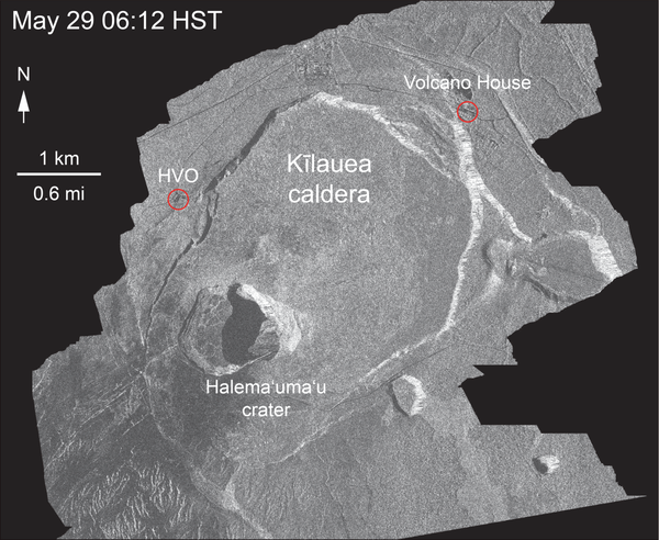
Kīlauea Volcano — Satellite View of Kīlauea SummitThe WorldView-3 satellite acquired this view of Kīlauea's summit on July 3. Despite a few clouds, the area of heaviest fractures in the caldera is clear. Views into the expanding Halema‘uma‘u crater reveal a pit floored by rubble. HVO, on the northwest caldera rim, is labeled.
Kīlauea Volcano — Satellite View of Kīlauea Summit
Kīlauea Volcano — Satellite View of Kīlauea SummitThe WorldView-3 satellite acquired this view of Kīlauea's summit on July 3. Despite a few clouds, the area of heaviest fractures in the caldera is clear. Views into the expanding Halema‘uma‘u crater reveal a pit floored by rubble. HVO, on the northwest caldera rim, is labeled.

Kīlauea Volcano — Ocean Entry at Kapoho
Having crusted over about 0.8 km (0.5 mi) upchannel from the ocean entry, lava oozes from the flow's molten interior to enter the sea along a broad flow front on the northern (Kapoho) side of the flow.
Having crusted over about 0.8 km (0.5 mi) upchannel from the ocean entry, lava oozes from the flow's molten interior to enter the sea along a broad flow front on the northern (Kapoho) side of the flow.

Kīlauea Volcano — Lavafall Near Kapoho Crater
Near the Kapoho Crater, in the area called Four Corners, the lava channel makes a 90-degree bend. After lava exits the bend, it makes a short drop to form a lavafall. A side channel makes a short surface diversion before rejoining the existing channel.
Near the Kapoho Crater, in the area called Four Corners, the lava channel makes a 90-degree bend. After lava exits the bend, it makes a short drop to form a lavafall. A side channel makes a short surface diversion before rejoining the existing channel.

Kīlauea Volcano — Aerial of Kapoho Area
Aerial view of the lava channel and active margins between Kapoho Crater (upper right) and the coast (lower left). The northern margin of the flow field is advancing at several points in the area of Kapoho Ag and Beach Lots (vegetated areas in center of image). Image courtesy of Hawaii County Fire Department.
Aerial view of the lava channel and active margins between Kapoho Crater (upper right) and the coast (lower left). The northern margin of the flow field is advancing at several points in the area of Kapoho Ag and Beach Lots (vegetated areas in center of image). Image courtesy of Hawaii County Fire Department.