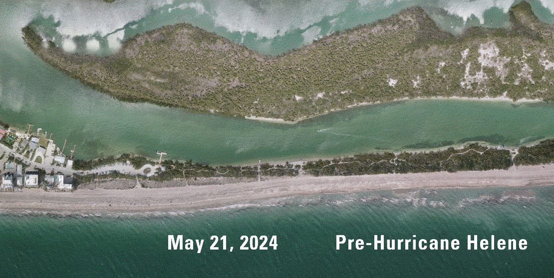
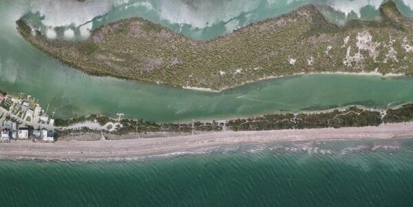
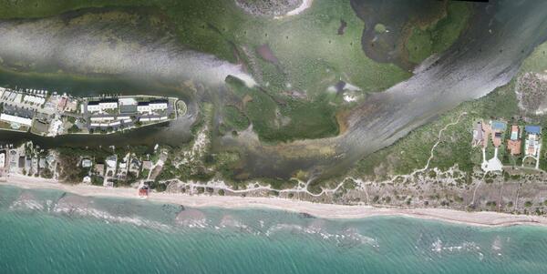
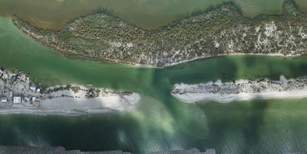
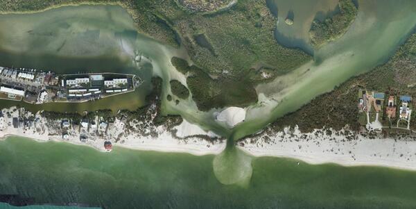
U.S. flag

An official website of the United States government

Multimedia

The Coastal and Marine Hazards and Resources Program shares a wide range of resources to help explain and illustrate scientific concepts, our scientific activities, expertise, technology, tools, and other educational resources. Through newsletters, multimedia resources, special events, and other products, you can learn more about the many ways our science supports the Nation.

Images

Cover image for Hawai'i Abyssal Nodules Expedition video

In Fall 2025 the Hawaiʻi Abyssal Nodules and Associated Ecosystems Expedition, led by USGS scientists, will investigate the geology, minerals, and environmental setting of the deep seabed offshore Moku o Keawe (Hawaiʻi Island) in the U.S. Exclusive Economic Zone. This work is part of ongoing collaborative efforts with BOEM and NOAA.

In Fall 2025 the Hawaiʻi Abyssal Nodules and Associated Ecosystems Expedition, led by USGS scientists, will investigate the geology, minerals, and environmental setting of the deep seabed offshore Moku o Keawe (Hawaiʻi Island) in the U.S. Exclusive Economic Zone. This work is part of ongoing collaborative efforts with BOEM and NOAA.

social media post
Social Media: Sediment Movement in Cape Cod Bay

To assess our #sedimenttransport prediction techniques, #USGS scientists deployed a high-tech instrument off #SandyNeckBeach in Barnstable, Massachusetts from March-April 2021 to measure water velocity, temperature, and salinity, wave pressure, tidal force, seabed changes, and sediment characteristics. 

To assess our #sedimenttransport prediction techniques, #USGS scientists deployed a high-tech instrument off #SandyNeckBeach in Barnstable, Massachusetts from March-April 2021 to measure water velocity, temperature, and salinity, wave pressure, tidal force, seabed changes, and sediment characteristics. 

Three people on beach with camera mounted on tall pole
Marconi Beach CoastCam Maintenance

The USGS uses a nationwide network of coastal observing cameras (CoastCams) to monitor coastal conditions in near real-time and support research on a variety of coastal processes and hazards.

The USGS uses a nationwide network of coastal observing cameras (CoastCams) to monitor coastal conditions in near real-time and support research on a variety of coastal processes and hazards.

social media post
Social Media: Biogeomorphic salt marsh model

A new study introduces a cutting-edge biogeomorphic model (UBMorph) to help predict how #ChesapeakeBay #saltmarshes will change over time. Using UBMorph, researchers found that 404 square kilometers (37%) of vegetated #marsh area in Chesapeake Bay could be lost by 2110.

A new study introduces a cutting-edge biogeomorphic model (UBMorph) to help predict how #ChesapeakeBay #saltmarshes will change over time. Using UBMorph, researchers found that 404 square kilometers (37%) of vegetated #marsh area in Chesapeake Bay could be lost by 2110.

social media post
Social Media: Shoreline Change of Long Island Sound

A new #datarelease contains a GIS compilation of vector shorelines and associated #shorelinechange data from the 1800s to the 2010s for the coast of Long Island Sound, #NewYork and #Connecticut. 

A new #datarelease contains a GIS compilation of vector shorelines and associated #shorelinechange data from the 1800s to the 2010s for the coast of Long Island Sound, #NewYork and #Connecticut. 

Videos

Cover image for Hawai'i Abyssal Nodules Expedition video Cover image for Hawai'i Abyssal Nodules Expedition video
Hawai'i Abyssal Nodules Expedition (AD)

In Fall 2025 the Hawaiʻi Abyssal Nodules and Associated Ecosystems Expedition, led by USGS scientists, will investigate the geology, minerals, and environmental setting of the deep seabed offshore Moku o Keawe (Hawaiʻi Island) in the U.S. Exclusive Economic Zone. This work is part of ongoing collaborative efforts with BOEM and NOAA.

In Fall 2025 the Hawaiʻi Abyssal Nodules and Associated Ecosystems Expedition, led by USGS scientists, will investigate the geology, minerals, and environmental setting of the deep seabed offshore Moku o Keawe (Hawaiʻi Island) in the U.S. Exclusive Economic Zone. This work is part of ongoing collaborative efforts with BOEM and NOAA.

USGS Coastal and Marine Field Operations (AD)

To conduct the science needed to understand coastal and marine geohazards, support habitat and resource management, and monitor how these environments change over time, the USGS Coastal and Marine Hazards and Resources Program relies on engineering, mechanical, and electronics expertise for field operations along the coast, in the nearshore environment, and in the d

To conduct the science needed to understand coastal and marine geohazards, support habitat and resource management, and monitor how these environments change over time, the USGS Coastal and Marine Hazards and Resources Program relies on engineering, mechanical, and electronics expertise for field operations along the coast, in the nearshore environment, and in the d

USGS Coastal and Marine Field Operations

To conduct the science needed to understand coastal and marine geohazards, support habitat and resource management, and monitor how these environments change over time, the USGS Coastal and Marine Hazards and Resources Program relies on engineering, mechanical, and electronics expertise for field operations along the coast, in the nearshore environment, and in the d

To conduct the science needed to understand coastal and marine geohazards, support habitat and resource management, and monitor how these environments change over time, the USGS Coastal and Marine Hazards and Resources Program relies on engineering, mechanical, and electronics expertise for field operations along the coast, in the nearshore environment, and in the d

Shoreline Seasonality of California's Beaches (AD)

Most of the world’s beaches have regular cycles of erosion and recovery, but new USGS research is showing that these cycles may be considerably different from common perceptions. 

Most of the world’s beaches have regular cycles of erosion and recovery, but new USGS research is showing that these cycles may be considerably different from common perceptions. 

Webcams

View of the beach
Sand Key, Florida
Sand Key, Florida
Sand Key, Florida

Most recent time-averaged image from Sand Key, Florida. The images are used to examine a range of coastal processes including shoreline position, the presence of an offshore sandbar, and the extent of wave runup on the beach. Camera hosted by Dan's Island Condo.

Most recent time-averaged image from Sand Key, Florida. The images are used to examine a range of coastal processes including shoreline position, the presence of an offshore sandbar, and the extent of wave runup on the beach. Camera hosted by Dan's Island Condo.

Zoomed-in view of a small section of the beach from Madeira Beach camera 2 shows water blurred by the time-averaging process
Time-averaged image at Madeira Beach, Florida, Camera 2

Time-averaged images, which represent the time-mean of all the images collected during a video, are used to identify areas where waves are breaking, which show up as bright white bands in the image.

Time-averaged images, which represent the time-mean of all the images collected during a video, are used to identify areas where waves are breaking, which show up as bright white bands in the image.

View of an Arctic beach area with gentle waters.
Nuvuk video camera 2 dark image

Two video cameras are installed atop a utility pole near the northernmost point of land in the United States at Nuvuk (Point Barrow), Alaska. The cameras point northwest toward the Arctic Ocean and the boundary between the Chukchi and Beaufort Seas. Every half hour during daylight hours, the cameras collect snapshots and video for 10 minutes.

Two video cameras are installed atop a utility pole near the northernmost point of land in the United States at Nuvuk (Point Barrow), Alaska. The cameras point northwest toward the Arctic Ocean and the boundary between the Chukchi and Beaufort Seas. Every half hour during daylight hours, the cameras collect snapshots and video for 10 minutes.

View of an Arctic beach area with gentle waters.
Nuvuk video camera 1 dark image

Two video cameras are installed atop a utility pole near the northernmost point of land in the United States at Nuvuk (Point Barrow), Alaska. The cameras point northwest toward the Arctic Ocean and the boundary between the Chukchi and Beaufort Seas. Every half hour during daylight hours, the cameras collect snapshots and video for 10 minutes.

Two video cameras are installed atop a utility pole near the northernmost point of land in the United States at Nuvuk (Point Barrow), Alaska. The cameras point northwest toward the Arctic Ocean and the boundary between the Chukchi and Beaufort Seas. Every half hour during daylight hours, the cameras collect snapshots and video for 10 minutes.

View of an Arctic beach area with gentle waters.
Nuvuk video camera 2 bright image

Two video cameras are installed atop a utility pole near the northernmost point of land in the United States at Nuvuk (Point Barrow), Alaska. The cameras point northwest toward the Arctic Ocean and the boundary between the Chukchi and Beaufort Seas. Every half hour during daylight hours, the cameras collect snapshots and video for 10 minutes.

Two video cameras are installed atop a utility pole near the northernmost point of land in the United States at Nuvuk (Point Barrow), Alaska. The cameras point northwest toward the Arctic Ocean and the boundary between the Chukchi and Beaufort Seas. Every half hour during daylight hours, the cameras collect snapshots and video for 10 minutes.

Was this page helpful?