
The Dungeness crab (Metacarcinus magister), whose range extends from the Aleutian Islands to the coast of California, is one of the species whose populations in San Francisco Bay have increased with a large-scale climatic shift that began in 1999. Photograph courtesy of the U.S. Fish and Wildlife Service.
Images
Coastal and Marine Hazards and Resources Program images.
Filter Total Items: 2413

Dungeness crab
The Dungeness crab (Metacarcinus magister), whose range extends from the Aleutian Islands to the coast of California, is one of the species whose populations in San Francisco Bay have increased with a large-scale climatic shift that began in 1999. Photograph courtesy of the U.S. Fish and Wildlife Service.

Stromatolites of Australia
Stromatolites growing in Hamelin Pool Marine Nature Reserve, Shark Bay in Western Australia. Photo by Paul Harrison, Reading, UK, CC BY-SA 3.0
Stromatolites growing in Hamelin Pool Marine Nature Reserve, Shark Bay in Western Australia. Photo by Paul Harrison, Reading, UK, CC BY-SA 3.0

Banda Aceh after the December 2004 Earthquake and Tsunami
Banda Aceh after the December 2004 Earthquake and TsunamiAn International Tsunami Survey Team studying the effects of the December 26, 2004 tsunami on Indonesia“‘’’s island of Sumatra documented wave heights of 20 to 30 m (65 to 100 ft) at the island's northwest end and found evidence suggesting that wave heights may have ranged from 15 to 30 m (50 to 100 ft) along at least a 100-km (60 mi) stretch of the northwest coast.

Measuring tsunami elevations in Sumatra in 2005
As part of an international tsunami survey team, Andy Moore of Kent State University takes measurement of a snapped-off tree trunk in Leupueng, Aceh in 2005, shortly after the deadly tsunami struck the island of Sumatra.
As part of an international tsunami survey team, Andy Moore of Kent State University takes measurement of a snapped-off tree trunk in Leupueng, Aceh in 2005, shortly after the deadly tsunami struck the island of Sumatra.

Measuring tree heights and water depth
In Leupueng, Indonesia, on the island of Sumatra, Dr. Guy Gelfenbaum measures the height of snapped-off tree trunks and sea level changes shortly after the December 26, 2004 earthquake and tsunami in the Indian Ocean.
In Leupueng, Indonesia, on the island of Sumatra, Dr. Guy Gelfenbaum measures the height of snapped-off tree trunks and sea level changes shortly after the December 26, 2004 earthquake and tsunami in the Indian Ocean.

Heavily damaged home in Banda Aceh, Sumatra from the 2004 tsunami
Heavily damaged home in Banda Aceh, Sumatra from the 2004 tsunamiA severely damaged home, or a portion of one, sits atop debris in Banda Aceh on the island of Sumatra. Damage was caused by a massive, highly destructive tsunami, triggered by a magnitude 9.1 earthquake just offshore of Sumatra, on December 26, 2004.

Boat carried inland by 2004 Indian Ocean tsunami
Boat carried inland by tsunami that struck Sumatra on December 26, 2004.
Boat carried inland by tsunami that struck Sumatra on December 26, 2004.

Kalmunai, Sri Lanka, after the December 2004 tsunami
Kalmunai, Sri Lanka, after the December 2004 tsunamiPhoto taken about 100 meters inland at Kalmunai on Sri Lanka's east coast.
Kalmunai, Sri Lanka, after the December 2004 tsunami
Kalmunai, Sri Lanka, after the December 2004 tsunamiPhoto taken about 100 meters inland at Kalmunai on Sri Lanka's east coast.

Tsunami sand deposit
Tsunami sand deposit at Nilaveli Beach on the northeastern coast of Sri Lanka following the December 26th, 2004 earthquake and tsunami in the Indian Ocean. The sand deposited by the tsunami is light colored and overlies a pre-tsunami darker sandy soil.
Tsunami sand deposit at Nilaveli Beach on the northeastern coast of Sri Lanka following the December 26th, 2004 earthquake and tsunami in the Indian Ocean. The sand deposited by the tsunami is light colored and overlies a pre-tsunami darker sandy soil.

Tsunami Hazards in the Santa Barbara Channel
Large-scale poster describing USGS work.
The USGS, in cooperation with Moss Landing Marine Laboratory, mapped the slopes of the Santa Barbara Channel using sonar. We combined this with deep sea drilling records and seismic records to make these maps.
Large-scale poster describing USGS work.
The USGS, in cooperation with Moss Landing Marine Laboratory, mapped the slopes of the Santa Barbara Channel using sonar. We combined this with deep sea drilling records and seismic records to make these maps.

Big Sur Coastal Landslides
Large-scale poster describing USGS work.
The USGS studied air photos of the Big Sur coast taken in 1942 and 1994, in cooperation with the California Department of Transportation (Caltrans) and the University of California at Santa Cruz (UCSC).
Large-scale poster describing USGS work.
The USGS studied air photos of the Big Sur coast taken in 1942 and 1994, in cooperation with the California Department of Transportation (Caltrans) and the University of California at Santa Cruz (UCSC).

Diagram of deep-seated landslide, from USGS Fact Sheet 3004–3072
Diagram of deep-seated landslide, from USGS Fact Sheet 3004–3072Diagram of deep-seated landslide, from USGS Fact Sheet 3004–3072, “Landslide Types and Processes.”
Diagram of deep-seated landslide, from USGS Fact Sheet 3004–3072
Diagram of deep-seated landslide, from USGS Fact Sheet 3004–3072Diagram of deep-seated landslide, from USGS Fact Sheet 3004–3072, “Landslide Types and Processes.”

Aerial photo shows coastal Florida home damage from Hurricane Jeanne
Aerial photo shows coastal Florida home damage from Hurricane JeannePhotograph of the Florida coastline shows storm damage after Hurricane Jeanne's passage.
Aerial photo shows coastal Florida home damage from Hurricane Jeanne
Aerial photo shows coastal Florida home damage from Hurricane JeannePhotograph of the Florida coastline shows storm damage after Hurricane Jeanne's passage.

Panoramic view of Weedon Island, Pinellas County, Florida
Panoramic view of Weedon Island, Pinellas County, FloridaThe Weedon Island Preserve is a 3,190-acre coastal system in Tampa Bay, Florida that is comprised of aquatic and upland ecosystems.
Panoramic view of Weedon Island, Pinellas County, Florida
Panoramic view of Weedon Island, Pinellas County, FloridaThe Weedon Island Preserve is a 3,190-acre coastal system in Tampa Bay, Florida that is comprised of aquatic and upland ecosystems.
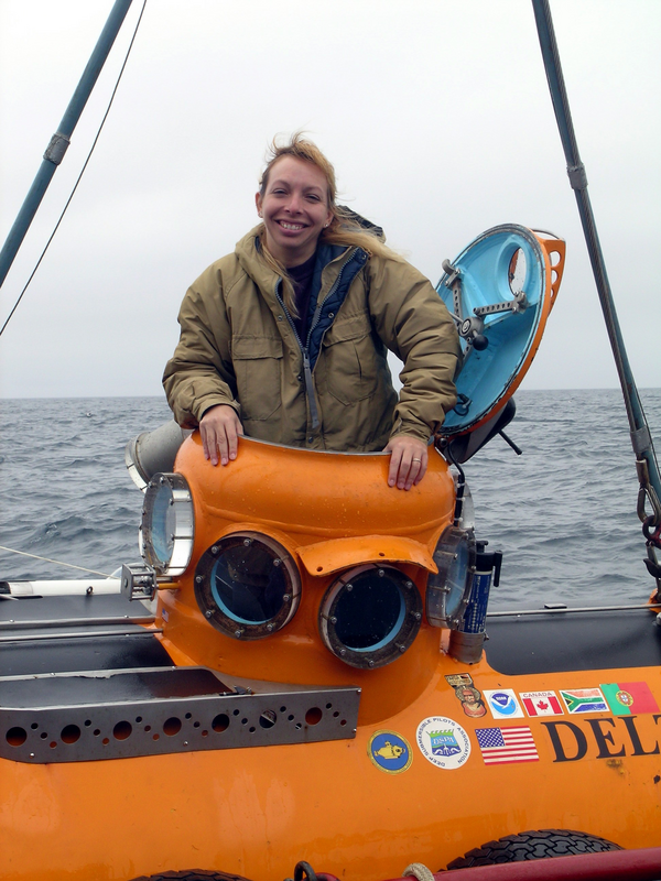
Dr. Christina Kellogg emerges from the submersible Delta
Dr. Christina Kellogg emerges from the submersible DeltaDr. Christina Kellogg emerges from the submersible Delta after collecting coral samples in the Aleutian Islands in 2004.
Dr. Christina Kellogg emerges from the submersible Delta
Dr. Christina Kellogg emerges from the submersible DeltaDr. Christina Kellogg emerges from the submersible Delta after collecting coral samples in the Aleutian Islands in 2004.

Oceanography Beyond the Golden Gate
Large-scale poster describing USGS work.

Coral shading experiment during a bleaching event
Here are shown a series of photographs of a rice coral (Montipora capitata) shaded with light filters during a natural “coral bleaching” event observed during anomalously high ocean temperatures in Autumn of 2004 on the island of Oʻahu, Hawaiʻi.
Here are shown a series of photographs of a rice coral (Montipora capitata) shaded with light filters during a natural “coral bleaching” event observed during anomalously high ocean temperatures in Autumn of 2004 on the island of Oʻahu, Hawaiʻi.

Closeup photograph of home damaged by Hurricane Jeanne in Florida
Closeup photograph of home damaged by Hurricane Jeanne in FloridaZoomed in aerial photograph of a home on the beach near Stuart, Florida, severely damaged by Hurricane Jeanne in September 2004.
Closeup photograph of home damaged by Hurricane Jeanne in Florida
Closeup photograph of home damaged by Hurricane Jeanne in FloridaZoomed in aerial photograph of a home on the beach near Stuart, Florida, severely damaged by Hurricane Jeanne in September 2004.

Great Barrier Reef satellite image
The Great Barrier Reef arches over 2000 kilometers along the northeast coast of Australia. The white calcium carbonate that coats the coral reflects light, making the water above the reef appear bright blue from space.
The Great Barrier Reef arches over 2000 kilometers along the northeast coast of Australia. The white calcium carbonate that coats the coral reflects light, making the water above the reef appear bright blue from space.

Storage vans, referred to as the "Freezer Farm"
Storage vans, referred to as the "Freezer Farm" sit outside the Woods Hole Science Center
Storage vans, referred to as the "Freezer Farm" sit outside the Woods Hole Science Center

Swath bathymetric map of the Cape Fear submarine slide
Swath bathymetric map of the Cape Fear submarine slideSwath bathymetric map of the Cape Fear submarine slide, the largest slide on the US Atlantic coast. Data were collected on the R/V Atlantis in 2003.
Swath bathymetric map of the Cape Fear submarine slide
Swath bathymetric map of the Cape Fear submarine slideSwath bathymetric map of the Cape Fear submarine slide, the largest slide on the US Atlantic coast. Data were collected on the R/V Atlantis in 2003.