
Ozette Lake: A natural seismograph along the northern Cascadia Subduction Zone (Video)
Geonarrative: Deciphering Nature's Seismograph
How Sediments Record Past Earthquakes and Inform Future Hazard Assessments
Study: Uncovering 14,000 Years of Seismic Activity in Northern Cascadia
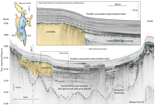
Ozette Lake, on Washington State’s Olympic Peninsula, is the largest unaltered lake in the state. Glacially carved to depths of about 100 meters (328 feet), the lake is just 4.8 kilometers (3 miles) from the present-day Pacific coastline. Its sediments preserve a record of seismic activity going back more than 14,000 years.
Ozette Lake sits along what was the southern extent of the Juan de Fuca lobe of the Cordilleran Ice Sheet, a mass of ice that covered most of North America during the last Ice Age. Its depth and proximity to the coast along the Cascadia Subduction Zone (CSZ) make it an ideal research site for lacustrine paleoseismology, the study of past seismic activity preserved in lake sediments.
In 2018, the USGS Coastal and Marine Hazards and Resources Program, with its expertise in seafloor and sub-bottom mapping, geophysical data collection in coastal and marine settings, and advanced data processing capabilities, began prioritizing subduction zone science. The Program agreed that the Pacific Coastal and Marine Science Center in Santa Cruz, California, would study the CSZ in earnest.
Part of the Coastal and Marine Geohazards Project would focus on offshore work, led by Research Geologist Jenna Hill: mapping and collecting sediment cores from the fault zone itself, characterizing marine geohazards such as turbidity flows, underwater landslides, and seabed deformation. Another group, led by Research Geologist Danny Brothers, focused on a land-based component of the CSZ: finding sedimentary evidence of seismic activity in the region's numerous lakes.
“The sediment records preserved in lakes were widely understudied by USGS at the time: the Earthquake Hazards Program didn’t study them, Coastal and Marine Hazards didn’t study them, Water Resources dabbled in them, Ecosystems didn’t study them outside of paleoclimate research," said Brothers. "We’ve known for more than two decades that lake sediments record seismic activity, preserving distinct features caused by shaking. In some cases, these features are preserved in much finer detail than in terrestrial or marine sediments. The work at Ozette was foundational for our current focus on lacustrine paleoseismology, not just within Cascadia but in other fault zones across the U.S. We teamed up with Brian Sherrod and other members of the Pacific Northwest Earthquake Hazards Project to examine the lacustrine records, combining expertise and capabilities from both programs.”
Soon after deciding to target Ozette Lake for a reconnaissance trip in 2018, the M7.1 Anchorage Earthquake occurred on November 30 of that year, spawning a parallel project (with Peter Haeussler and Rob Witter of the USGS Alaska Science Center) in southern Alaska to investigate how shaking was recorded in lakes surrounding the epicenter. Disaster Relief Supplemental Appropriations funding provided an opportunity to expand the scientific toolbox by acquiring new mapping and coring capabilities optimized for deep-water remote lakes, including a Uwitech coring platform, a new chirp sub-bottom profiler, and a Norbit multibeam echosounder. The funds also went toward hiring Drake Singleton as a Mendenhall post-doc to help lead the effort in Alaska. Starting in 2020, the team collected data in more than 12 lakes, and has expanded to include colleagues in other science centers and academic institutions.
Related

Coastal and Marine Geohazards of the U.S. West Coast and Alaska
Uncovering 14,000 Years of Seismic Activity in Northern Cascadia Uncovering 14,000 Years of Seismic Activity in Northern Cascadia
Related
Coastal and Marine Geohazards of the U.S. West Coast and Alaska