
Coastal Change Hazards - Technical Capabilities and Applications
Digital Shoreline Analysis System (DSAS)
Coastal Change Hazards Portal
Our Coast Our Future
Hazard and Exposure Reporting and Analytics (HERA)
Total Water Level and Coastal Change Forecast Viewer
The Technical Capabilities and Applications (TCA) component of the Coastal Change Hazards (CCH) program focus leverages technical talent across the Coastal and Marine Hazards and Resources Program (CMHRP) to bridge capability, expertise, and cooperation between the three Coastal and Marine Science Centers: Woods Hole, Massachusetts; St. Petersburg, Florida; and Santa Cruz, California. TCA provides a Program-wide cadre of technical expertise that promotes cross-training and familiarity on methods, data sharing and visualization, scientific techniques, and publication standards that sustain regional- to national-scale CCH assessment products.
Data Visualization

Data visualization products use graphical representations of information and data to provide an accessible way to see and understand trends, outliers, and patterns.
Forecasting

Forecasts use scientific understanding and uncertainty to project how dynamic coastal hazards can influence coastal resources and human lives.
Tools
Tools are comprehensive scientific products that draw from multiple data sources and span multiple applications.

TCA provides CCH with technical expertise and support, including guidance on the best data and metadata practices. Technical experts across the three centers develop and share techniques, methods, data visualization, and collection processes with one another. They work with CMHRP groups to improve internal data sharing across the centers, including data management, storage, and publishing. TCA advocates for consistent and efficient data publishing requirements, which support standardization of products at national scales, facilitates data usability across multiple projects, and incorporates data into web mapping applications.
CCH research, coupled with TCA expertise, results in products that provide critical information to inform decisions and reduce the risk and consequences of coastal change hazards throughout the Nation.
Data Visualization Products
Data visualization products use graphical representations of information and data in a user-friendly way to see and understand trends, outliers, and patterns in data. Examples include:
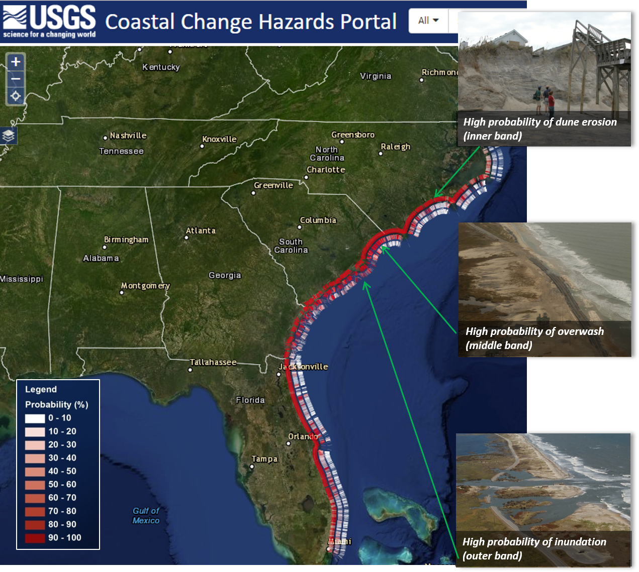
- The Coastal Change Hazards Portal provides national assessments of coastal change at scales useful for local communities and scientifically credible data suitable for land use planning projects, emergency preparedness, storm response and recovery protocols, and infrastructure, ecosystem, and resource management decision-making. Users can explore the potential for storm-induced coastal erosion, forecasts of extreme water levels, historical shoreline change, and vulnerability to sea-level rise. Check out the Real-Time Forecasts of Coastal Change geonarrative to learn more.
Forecasting
An important element of USGS CCH science is applying new understanding to forecast or project future conditions and hazards. This is commonly done by using computer analyses to develop maps of potential hazards from storms and other natural processes. Forecasts are shared broadly using web-based portals to assist with the management of coastal resources. Examples include:
- The Coastal Storm Modeling System (CoSMoS) simulates storm-induced coastal flooding, erosion, and cliff failures over large geographic scales. CoSMoS was developed for hindcast studies, operational applications, and future climate scenarios, to provide emergency responders and coastal planners with critical storm-hazards information. This information can be used to increase public safety, mitigate physical damages, and more effectively manage and allocate resources within complex coastal settings. Check out the Coastal Storms geonarrative to learn more.

- The Total Water Level and Coastal Change Forecast Viewer provides coastal communities with advance notice of potential for elevated coastal water levels and coastal changes on sandy beaches that may threaten safety, infrastructure, or resources. The continuously operating model is a collaboration between USGS and NOAA ,and provides hourly data for select regions of the U.S. coastline based on local beach characteristics. Check out the Real-Time Forecasts of Coastal Change geonarrative to learn more.

Tools
Tools are comprehensive scientific products that draw from multiple data sources and span multiple applications.
The Digital Shoreline Analysis System (DSAS) is used to calculate shoreline change, or the movement of other linear features, over time. DSAS facilitates the shoreline change-calculation process, provides rate-of-change information, and allows users to calculate the reliability of its results. The software is also suitable for any generic application that calculates positional change over time. Therefore, it can be used to assess change of glacier limits in sequential aerial photos, river edge boundaries, or land-cover changes. National and state governments worldwide have used the tool in support of resource management and critical coastal decision-making. Check out the National Shoreline Change geonarrative to learn more.


Coastal Change Hazards

Coastal Change Hazards - Technical Capabilities and Applications

Coastal Change Hazards - Stakeholder Engagement and Communications

Coastal Change Hazards - Research
The Technical Capabilities and Applications (TCA) component of the Coastal Change Hazards (CCH) program focus leverages technical talent across the Coastal and Marine Hazards and Resources Program (CMHRP) to bridge capability, expertise, and cooperation between the three Coastal and Marine Science Centers: Woods Hole, Massachusetts; St. Petersburg, Florida; and Santa Cruz, California. TCA provides a Program-wide cadre of technical expertise that promotes cross-training and familiarity on methods, data sharing and visualization, scientific techniques, and publication standards that sustain regional- to national-scale CCH assessment products.
Data Visualization
Data visualization products use graphical representations of information and data to provide an accessible way to see and understand trends, outliers, and patterns.
Forecasting
Forecasts use scientific understanding and uncertainty to project how dynamic coastal hazards can influence coastal resources and human lives.
Tools
Tools are comprehensive scientific products that draw from multiple data sources and span multiple applications.
TCA provides CCH with technical expertise and support, including guidance on the best data and metadata practices. Technical experts across the three centers develop and share techniques, methods, data visualization, and collection processes with one another. They work with CMHRP groups to improve internal data sharing across the centers, including data management, storage, and publishing. TCA advocates for consistent and efficient data publishing requirements, which support standardization of products at national scales, facilitates data usability across multiple projects, and incorporates data into web mapping applications.
CCH research, coupled with TCA expertise, results in products that provide critical information to inform decisions and reduce the risk and consequences of coastal change hazards throughout the Nation.
Data Visualization Products
Data visualization products use graphical representations of information and data in a user-friendly way to see and understand trends, outliers, and patterns in data. Examples include:
- The Coastal Change Hazards Portal provides national assessments of coastal change at scales useful for local communities and scientifically credible data suitable for land use planning projects, emergency preparedness, storm response and recovery protocols, and infrastructure, ecosystem, and resource management decision-making. Users can explore the potential for storm-induced coastal erosion, forecasts of extreme water levels, historical shoreline change, and vulnerability to sea-level rise. Check out the Real-Time Forecasts of Coastal Change geonarrative to learn more.
Forecasting
An important element of USGS CCH science is applying new understanding to forecast or project future conditions and hazards. This is commonly done by using computer analyses to develop maps of potential hazards from storms and other natural processes. Forecasts are shared broadly using web-based portals to assist with the management of coastal resources. Examples include:
- The Coastal Storm Modeling System (CoSMoS) simulates storm-induced coastal flooding, erosion, and cliff failures over large geographic scales. CoSMoS was developed for hindcast studies, operational applications, and future climate scenarios, to provide emergency responders and coastal planners with critical storm-hazards information. This information can be used to increase public safety, mitigate physical damages, and more effectively manage and allocate resources within complex coastal settings. Check out the Coastal Storms geonarrative to learn more.
- The Total Water Level and Coastal Change Forecast Viewer provides coastal communities with advance notice of potential for elevated coastal water levels and coastal changes on sandy beaches that may threaten safety, infrastructure, or resources. The continuously operating model is a collaboration between USGS and NOAA ,and provides hourly data for select regions of the U.S. coastline based on local beach characteristics. Check out the Real-Time Forecasts of Coastal Change geonarrative to learn more.
Tools
Tools are comprehensive scientific products that draw from multiple data sources and span multiple applications.
The Digital Shoreline Analysis System (DSAS) is used to calculate shoreline change, or the movement of other linear features, over time. DSAS facilitates the shoreline change-calculation process, provides rate-of-change information, and allows users to calculate the reliability of its results. The software is also suitable for any generic application that calculates positional change over time. Therefore, it can be used to assess change of glacier limits in sequential aerial photos, river edge boundaries, or land-cover changes. National and state governments worldwide have used the tool in support of resource management and critical coastal decision-making. Check out the National Shoreline Change geonarrative to learn more.
Coastal Change Hazards
Coastal Change Hazards - Technical Capabilities and Applications
Coastal Change Hazards - Stakeholder Engagement and Communications