
Coastal Change Hazards - Research
The Research component of the Coastal Change Hazards (CCH) program focus conducts basic and applied research that is important for understanding the Nation’s dynamic coasts and increasing the resiliency of resources and lives along these coasts. Research is conducted through a variety of projects across the three Coastal and Marine Science Centers: Woods Hole, Massachusetts; St. Petersburg, Florida; and Santa Cruz, California.
Observations

Using a variety of observational techniques, the USGS collects scientific information that is the basis of discovery and research.
Understanding

Scientists use observations and analyses to understand and describe coastal phenomena that cause flooding, erosion, and other changes to the coast.
Modeling

Conceptual, statistical, and mathematical models are used to describe and understand coastal responses to driving forces such as wind, waves, ocean currents, and water levels.

Research is focused on observing, understanding, and modeling coastal processes and responses to both natural forcing and human disturbances across diverse environments. This work is focused on open sandy coasts, coral reefs, permafrost coasts, sea cliffs, sand dunes, estuaries, marshes, and coastal watersheds. Scientific research, which is vetted through a rigorous peer-review process, is the foundation for USGS products that provide users with actionable information to address challenges along the coast.
Observations
To understand the type, scale, and risk of coastal change hazards, the USGS CCH program focus makes scientific observations of what can be seen, recorded, and measured. These observations provide the primary data used to build understanding and develop models. CCH collects a wide variety of observations and measurements, including mapping of beaches, wetlands, and under the surface of the seafloor; characterization of substrates, habitats, and ecological systems across coastal and marine sites; and the measurement of physical conditions including waves, currents, and water levels during storms.

One technique to map beaches and coastal wetlands is the use of unmanned aerial systems (UAS) to capture imagery over a study site. These photographs may be used to derive surface elevations, map the extent of vegetation, or record baseline or post-event conditions for an area of interest
The techniques used for observation are specific to the environment. Observations of coral reefs commonly incorporate SCUBA surveys that can be compared to historic observations to determine how the reefs have changed over time.
Collecting the data needed to answer a science question often requires designing new approaches or technologies. For example, research aimed at understanding the current and future persistence of wetlands requires observations of the biogeochemical, sedimentological, and hydrological factors that affect these ecosystems.
Explore the diverse array of CCH projects:

- Coastal Climate Impacts
- Geologic Mapping
- Coastal National Elevation Database Applications Project
- Coastal Alaska Processes and Hazards
- Estuarine Processes, Hazards, and Ecosystems
- Coastal Habitats in Puget Sound
- Biogeochemical Drivers of Wetland Persistence and Feedbacks on Coastal Hazards
- Sediment Transport Coastal Environments
- Sea-Level Rise Hazards and Decision Support
- Coastal Sediment Availability and Flux Project
- National Assessment of Coastal Change Hazards
- Coastal Model Applications and Field Measurements
- Estuarine and Marsh Geology Research Project
- Past, Present, and Future Coral Reefs
- Cross-Shore and Inlets Processes Project
- Remote Sensing Coastal Change
- Geologic and Morphologic Evolution of Coastal Margins
- Barrier Island Comprehensive Monitoring
- Coastal Change Hazards Stakeholder Engagement and Communications
- Coastal Change Hazards Technical Capabilities and Applications
- Coastal Resource Evaluation for Management Application
- Coral Reef Ecosystems Studies
- DUNEX Nearshore Geology
- Estuarine and Marsh Geology
- Landscape Response and Disturbance
- Coral Microbial Ecology
- Total Water Level and Coastal Change Forecast
- State of Our Nation's Coast
- Sea Level Rise and Carbon Cycle Processes


Understanding
Many coastal change hazards are complex interactions of natural phenomena. By analyzing what is seen, recorded, and measured, USGS scientists gain a deeper understanding of these intricate coastal change hazards and natural phenomena. Research in CCH is focused on improving the collective understanding of complex coastal processes such as the causes, extent, and intensity of coastal flooding and topographic changes, and the effects of human interactions on coastal systems. While CCH has a national focus, much of the understanding of complex coastal interactions and integrated systems come from focused studies in unique environments, such as coastal wetlands, barrier islands, permafrost coasts, or cliff-backed beaches. Often, the knowledge gained from these regional or local studies can be applied nationally to address coastal change hazard issues in similar environments.


Modeling

Models are developed to integrate our understanding of phenomenon or events. Models are applied to test and assess the uncertainty of our understanding. Types of models used by USGS scientists include conceptual models that describe how coastal systems work, statistical models that capture relationships and trends in data, and mathematical models that use equations to describe coastal systems.
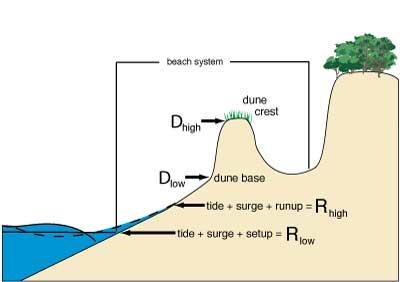
Conceptual models such as the Storm-Impact Scale can help assess the potential vulnerability of a particular stretch of coast. This conceptual model scales the impacts of storms on barrier islands by including storm-induced water levels including storm surge, astronomical tide, and wave runup (Rhigh) and illustrates its position relative to local dune morphology such as the elevation of the dune crest (Dhi) and dune base (Dlow).
The Coastal Response model seeks to simulate (or project) the response to sea-level rise across the coastal landscape under future sea level scenarios by evaluating the likelihood of inundation, as well as dynamic coastal change. Probabilistic predictions ensure that consideration of uncertainty is robust and is straightforward to integrate in decision making. The coastal response information can be used to inform corresponding habitat models, as well as to map out alternative management strategies to optimize conservation efforts and allocate regional resources in the future.


Explore the diverse array of CCH projects

Coastal Change Hazards

Remote Sensing Coastal Change

Sediment Transport in Coastal Environments

Coral Reef Project

Coastal Climate Impacts

Coastal Habitats in Puget Sound

Climate impacts to Arctic coasts

Coastal Change Hazards - Technical Capabilities and Applications

Coastal Change Hazards - Stakeholder Engagement and Communications

Coastal Change Hazards - Research

Coastal Sediment Availability and Flux (CSAF)

Sea-Level Rise Hazards and Decision Support

Estuarine Processes, Hazards, and Ecosystems
The Research component of the Coastal Change Hazards (CCH) program focus conducts basic and applied research that is important for understanding the Nation’s dynamic coasts and increasing the resiliency of resources and lives along these coasts. Research is conducted through a variety of projects across the three Coastal and Marine Science Centers: Woods Hole, Massachusetts; St. Petersburg, Florida; and Santa Cruz, California.
Observations
Using a variety of observational techniques, the USGS collects scientific information that is the basis of discovery and research.
Understanding
Scientists use observations and analyses to understand and describe coastal phenomena that cause flooding, erosion, and other changes to the coast.
Modeling
Conceptual, statistical, and mathematical models are used to describe and understand coastal responses to driving forces such as wind, waves, ocean currents, and water levels.
Research is focused on observing, understanding, and modeling coastal processes and responses to both natural forcing and human disturbances across diverse environments. This work is focused on open sandy coasts, coral reefs, permafrost coasts, sea cliffs, sand dunes, estuaries, marshes, and coastal watersheds. Scientific research, which is vetted through a rigorous peer-review process, is the foundation for USGS products that provide users with actionable information to address challenges along the coast.
Observations
To understand the type, scale, and risk of coastal change hazards, the USGS CCH program focus makes scientific observations of what can be seen, recorded, and measured. These observations provide the primary data used to build understanding and develop models. CCH collects a wide variety of observations and measurements, including mapping of beaches, wetlands, and under the surface of the seafloor; characterization of substrates, habitats, and ecological systems across coastal and marine sites; and the measurement of physical conditions including waves, currents, and water levels during storms.
One technique to map beaches and coastal wetlands is the use of unmanned aerial systems (UAS) to capture imagery over a study site. These photographs may be used to derive surface elevations, map the extent of vegetation, or record baseline or post-event conditions for an area of interest
The techniques used for observation are specific to the environment. Observations of coral reefs commonly incorporate SCUBA surveys that can be compared to historic observations to determine how the reefs have changed over time.
Collecting the data needed to answer a science question often requires designing new approaches or technologies. For example, research aimed at understanding the current and future persistence of wetlands requires observations of the biogeochemical, sedimentological, and hydrological factors that affect these ecosystems.
Explore the diverse array of CCH projects:
- Coastal Climate Impacts
- Geologic Mapping
- Coastal National Elevation Database Applications Project
- Coastal Alaska Processes and Hazards
- Estuarine Processes, Hazards, and Ecosystems
- Coastal Habitats in Puget Sound
- Biogeochemical Drivers of Wetland Persistence and Feedbacks on Coastal Hazards
- Sediment Transport Coastal Environments
- Sea-Level Rise Hazards and Decision Support
- Coastal Sediment Availability and Flux Project
- National Assessment of Coastal Change Hazards
- Coastal Model Applications and Field Measurements
- Estuarine and Marsh Geology Research Project
- Past, Present, and Future Coral Reefs
- Cross-Shore and Inlets Processes Project
- Remote Sensing Coastal Change
- Geologic and Morphologic Evolution of Coastal Margins
- Barrier Island Comprehensive Monitoring
- Coastal Change Hazards Stakeholder Engagement and Communications
- Coastal Change Hazards Technical Capabilities and Applications
- Coastal Resource Evaluation for Management Application
- Coral Reef Ecosystems Studies
- DUNEX Nearshore Geology
- Estuarine and Marsh Geology
- Landscape Response and Disturbance
- Coral Microbial Ecology
- Total Water Level and Coastal Change Forecast
- State of Our Nation's Coast
- Sea Level Rise and Carbon Cycle Processes
Understanding
Many coastal change hazards are complex interactions of natural phenomena. By analyzing what is seen, recorded, and measured, USGS scientists gain a deeper understanding of these intricate coastal change hazards and natural phenomena. Research in CCH is focused on improving the collective understanding of complex coastal processes such as the causes, extent, and intensity of coastal flooding and topographic changes, and the effects of human interactions on coastal systems. While CCH has a national focus, much of the understanding of complex coastal interactions and integrated systems come from focused studies in unique environments, such as coastal wetlands, barrier islands, permafrost coasts, or cliff-backed beaches. Often, the knowledge gained from these regional or local studies can be applied nationally to address coastal change hazard issues in similar environments.
Modeling
Models are developed to integrate our understanding of phenomenon or events. Models are applied to test and assess the uncertainty of our understanding. Types of models used by USGS scientists include conceptual models that describe how coastal systems work, statistical models that capture relationships and trends in data, and mathematical models that use equations to describe coastal systems.
Conceptual models such as the Storm-Impact Scale can help assess the potential vulnerability of a particular stretch of coast. This conceptual model scales the impacts of storms on barrier islands by including storm-induced water levels including storm surge, astronomical tide, and wave runup (Rhigh) and illustrates its position relative to local dune morphology such as the elevation of the dune crest (Dhi) and dune base (Dlow).
The Coastal Response model seeks to simulate (or project) the response to sea-level rise across the coastal landscape under future sea level scenarios by evaluating the likelihood of inundation, as well as dynamic coastal change. Probabilistic predictions ensure that consideration of uncertainty is robust and is straightforward to integrate in decision making. The coastal response information can be used to inform corresponding habitat models, as well as to map out alternative management strategies to optimize conservation efforts and allocate regional resources in the future.
Explore the diverse array of CCH projects
Coastal Change Hazards
Remote Sensing Coastal Change
Sediment Transport in Coastal Environments
Coral Reef Project
Coastal Climate Impacts
Coastal Habitats in Puget Sound
Climate impacts to Arctic coasts
Coastal Change Hazards - Technical Capabilities and Applications
Coastal Change Hazards - Stakeholder Engagement and Communications
Coastal Change Hazards - Research
Coastal Sediment Availability and Flux (CSAF)
Sea-Level Rise Hazards and Decision Support