
Typhoon Merbok Disaster Recovery Project: Accomplishments
Supported by Title VII of Division N of the Consolidated Appropriations Act, 2023, the Typhoon Merbok Disaster Emergency Recovery Efforts project addresses critical data and capacity gaps in coastal Alaska by generating high resolution environmental datasets, hazard analyses, and monitoring tools needed to quantify erosion, flooding, and permafrost-related risks at the community scale.
Through collaboration with state, federal, nonprofit, and local partners, we produced information on future flood and erosion hazards, real-time storm impacts, long-term shoreline change, and other foundational indicators that strengthen the scientific basis for risk assessments and infrastructure planning. These science products are designed to improve decision-relevant understanding of coastal hazards and to support engineers, planners, and community leadership in developing durable, evidence-based risk-reduction strategies.
Planning for future coastal hazards and risk
Forecasts of coastal hazards
Foundational data
Measuring coastal erosion
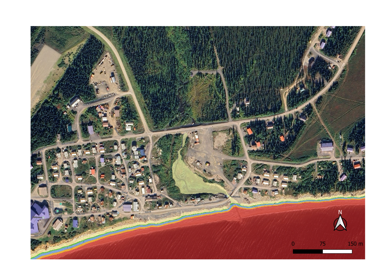
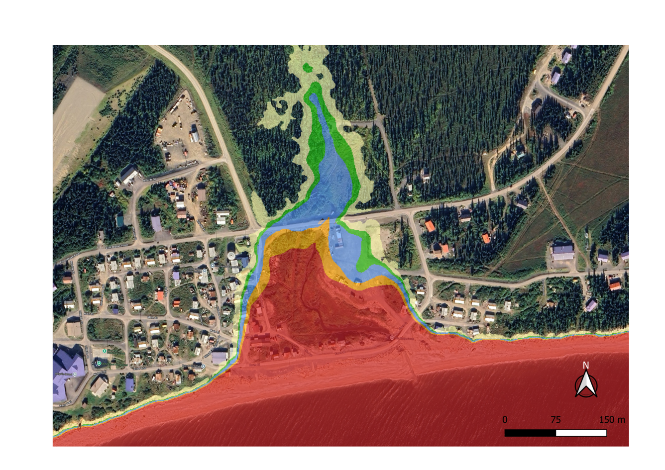
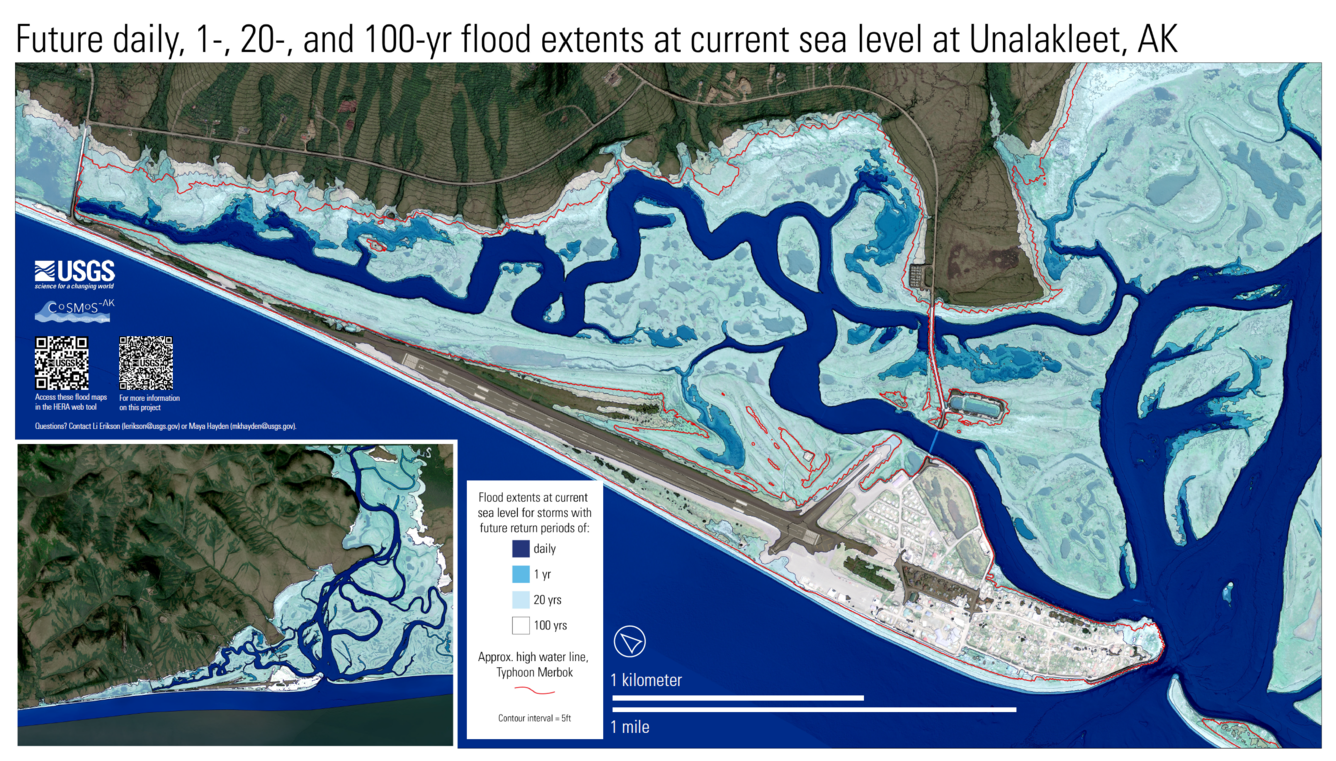
We adapted the U.S. Geological Survey’s Coastal Storm Modeling System (CoSMoS) for use in Alaska, incorporating the influence of sea ice on storm frequency and intensity, to quantify long-term coastal hazard exposure. Using historical and projected winds, atmospheric pressures, and sea ice from the latest sixth generation global climate models, we drove a suite of numerical models that downscale waves and water levels to the community scale. Timeseries representing past and future storms were evaluated for extremes and applied to overland flood modeling with 2D XBeach using new, high-resolution elevation surfaces assembled from the latest bathymetric and topographic datasets (see Data link below). We generated flood hazard maps for combinations of six sea-level rise scenarios, and five extreme storm return intervals, along with a no-storm baseline. Results are integrated into the HERA multi-hazard viewer, including exposure analytics summarizing impacts to critical infrastructure such as schools, clinics, transportation networks, and housing.
These products represent the first standardized, cross-community coastal flood hazard datasets of their kind in Alaska. Produced with consistent methodologies and coherent forcing data, they enable both rapid screening and detailed, decision relevant analyses for community scale risk assessment and long-range planning.
Highlights & Status
- Parcel-scale flood hazard datasets (flood extents/depths/elevations, velocity hazards, waves, and storm-driven morphodynamics provided as GIS layers and in a web viewer):
- 4 communities published (see Data link below)
- 6 communities near completion or in review
- 10 additional communities scheduled for completion by end of 2026
- Exposure metrics generated by combining flood extent maps with census derived data on population, housing, and infrastructure
- Joint occurrence statistics for extreme water levels and waves at 26 communities, both hindcast and anticipated future values (journal article in review)
- Comprehensive storm event catalog (1979–2022) for Alaska’s north and west coasts (journal article in review)
- Projected changes in extreme water levels and waves at 700+ nearshore sites (in preparation)
- Hourly nearshore wave timeseries from the Canadian border through Norton Sound
Who's using it/How is it used?
- Community leadership is using the HERA web viewer to inform decisions such as utility pole relocation and infrastructure siting.
- Consultants and researchers are using projected extreme water levels and waves as boundary conditions to model communities not directly covered in this project.
Forecasts of coastal hazards from an approaching storm
What we did and why it matters
In partnership with the State of Alaska DGGS, we developed rapid flood estimation tools that use 2–5day forecasts of extreme water levels to translate nearshore storm conditions into parcel scale flood impacts. These tools support NWS coastal storm warnings by providing clear visuals and impact estimates that improve forecast accuracy and emergency preparedness guidance.
Highlights & Status
- Supported NWS Fairbanks during mid-August 2024 storms by directing them to DGGS bathtub maps (AKFIT demo) for Kipnuk and Kwigilingok; model outputs also indicated no major flooding concerns in Unalakleet and Elim.
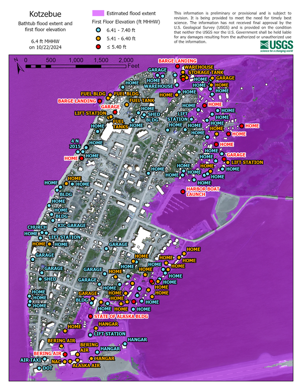
- Delivered flood hazard and exposure maps ahead of the October 2024 Kotzebue storm, aiding NWS forecasting and helping local and state responders identify vulnerable structures and prioritize recovery.
- Provided DGGS with five priority digital terrain models for integration into the AKFIT flood hazard viewer.
- Developed easy-to-use software for generating bathtub flood maps using only high- resolution elevation data.
Who's using it/how is it used?
- The National Weather Service uses these tools and data to convert nearshore extreme water level forecasts into community-scale impact assessments in near-real time
Foundational data to improve baseline and real-time coastal hazard information
What we did and why it matters
- We collected high‑quality elevation data and installed near‑real‑time coastal monitoring equipment in communities throughout the region to improve hazard forecasts and support local decision‑making. These datasets help quantify flood impacts, improve hazard models, and provide residents and emergency managers with better information before, during, and after storms.
Community-scale elevation data
Recent, accurate elevation data improve models for how flood waters will move across the landscape and impact infrastructure. Towards that end, we collected key elevation information, including:- Satellite-derived vertical land motion data across the Norton Sound Region (link)
- First-floor elevation measurements for buildings in 13 communities (link)
- Nearshore bathymetric surveys using single-beam sonar in three communities and GNSS beach profiles in seven communities (link)
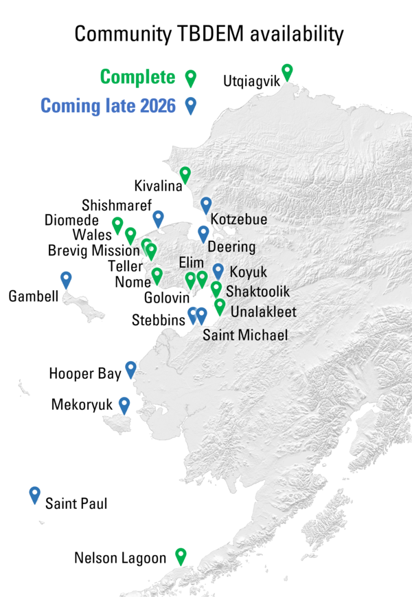
Using these data, we developed new high-resolution (1 meter) seamless topo-bathymetric elevation models for 11 communities, with 10 additional models underway for release in late 2026. (link) These datasets form the foundation for accurate flood modeling and planning.
- Near-real-time coastal monitoring
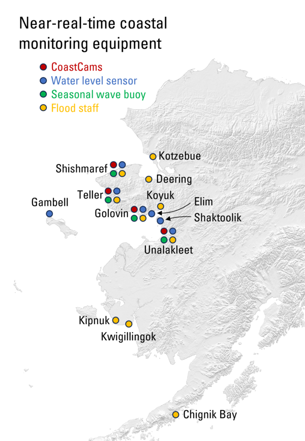
We also installed a suite of monitoring tools in 13 communities to track water levels, waves, and storm conditions in real time. These include:- Four CoastCam stations in Golovin, Shishmaref, Teller, and Unalakleet (link)
- Six water level sensors in Elim, Gambell, Golovin, Shishmaref, Teller, and Shaktoolik (link)
- Four seasonally operational wave buoys deployed to Golovin, Teller, Shishmaref, and Unalakleet (link)
- More than ten flood staffs for community photo documentation of high-water events (link)
Status
- Community-scale elevation data:
- Satellite-derived vertical land motion: complete for several communities with others in progress
- First-floor building elevations: Data for seven communities has been published and the remaining six are in review
- Nearshore bathymetric surveys and GNSS beach profiles: complete for a combined 10 communities
- TBDEMs: TBDEMs for 12 out of 21 communities are complete, with the remaining 9 expected late-2026.
- Near-real-time coastal monitoring
- All CoastCams, water level sensors wave buoys, and installed and collecting data (buoys collect data seasonally when feasible during ice-free conditions).
Who's using it/how is it used?
- Elevation data was used to support the mapping of future coastal hazards and risk. They are also being published and made available for researchers and consultants to produce their own models.
- Data from CoastCams, water-level sensors, and wave buoys provide a safe, simple way to check waves, ice, snow, and water levels. They help community boaters assess current conditions, support the National Weather Service during storms, and build an archive of past events for research and to support disaster declarations and strengthen applications for hazard-mitigation grants. Flood staffs allow residents to safely document flooding in their communities and submit photos for inclusion in a database managed by the state of Alaska (link). Similar tools have already proven essential during recent high-water events in communities such as Kipnuk (2024–2025).
- These instruments and datasets are designed to support local safety, storm preparedness, and community-driven documentation of flood impacts. We continue to work with partners and residents to maintain these tools, keep the data accessible, and ensure the information remains useful for decisions at the local and regional scale.
Our satellite remote sensing team has focused on a variety of topics during the duration of Project Merbok. These topics fall under four general themes: 1) satellite-derived shoreline mapping software and algorithm development; 2) developing records of satellite-derived shoreline-change; 3) developing outlets for releasing and visualizing satellite-derived shoreline change data; 4) exploring other applications of satellite data.
The team has accomplished the following during the duration of Project Merbok:
- Further developed the software CoastSeg, a Python-based platform for satellite-derived shoreline mapping. This software was made to give USGS scientists and other coastal scientists and engineers an improved way of applying the CoastSat techniques for mapping shorelines from satellite imagery.
- Constructed globally applicable training datasets as well as Alaska-specific datasets for training image filtering and image segmentation models. This was done to handle the challenges present within Alaska (e.g., sea-ice, distorted color spaces, short open water-seasons, thinner beach footprints, among many others) that are not present in more temperate areas where the majority of satellite-derived shoreline work had taken place prior to this project.
- Developed deep learning models for optical and infrared satellite image segmentation and image filtering. These models were needed to classify optical and infrared satellite imagery into water and land from which an instantaneous waterline contour is extracted from.
- Constructed, compiled, and refined a system of reference files and other supporting data (regions of interest, reference shorelines, reference polygons, transects, foreshore slopes, tide data, shore type) for over 4,000 km of the Alaskan coastline from the Canadian border along the Beaufort Sea to the Yukon Delta.
- Processed, through automated techniques, 40-years of Landsat, Sentinel, and PlanetScope imagery to build records of shoreline change for the northern Alaskan coastline. These shoreline change records are used to quantify historical patterns of shoreline behavior for the rapidly evolving Alaskan coastline.
- Developed a tiered system for providing the satellite-derived shoreline data, consisting of raw shorelines, filtered shorelines, time-averaged shorelines (annual, by decade), and statistical shorelines (e.g., mean, minimum, and maximum shorelines from the entire record). This ensures full reproducibility of the data generated during this project, to remove noise from the shoreline data, and to provide various forms (raw waterlines, instantaneous shorelines, annual shorelines, decadal shorelines, statistical shoreline metrics) of the data depending upon the end application.
- Constructed annual and by-decade averaged optical and infrared satellite imagery for northern Alaska. These images remove much of the noise present in the instantaneous imagery and allow for easier delineation of two-dimensional landform changes.
- Processed these annual and by-decade images through various techniques to delineate polygons of landform changes. These allow for two-dimensional quantification of landform changes that are not captured in transect-based measurements. They are especially useful for tracking the barrier islands along the Beaufort Sea.
Developed a data visualization website for the shoreline data through TerriaMap, to provide data as GeoPackages.
Media Sources/Usage: Public Domain. View Media Details
Landsat imagery timelapse showing coastal change from 1992-2023 near Stebbins, Alaska.

Why this work matters
Alaska’s coasts have been undergoing rapid geomorphic change over the last several decades, particularly at higher latitudes. Measuring and tracking these changes is important for understanding what types of patterns have been occurring. Understanding these patterns helps with preparing for a future where Alaska’s coastal landscapes are vastly different from ones that were once more stable and predictable. Making these measurements with satellite-based remote sensing eliminates the need to send personnel to remote field sites which can be costly, logistically challenging, and at times dangerous. Furthermore, using automated means to process vast volumes of satellite imagery speeds up the pace at which data and important information on coastal change are gathered and allows for the results to be computationally reproducible. This part is imperative in a world full of unexpected challenges. For example, if for some reason processed data had become corrupted and/or a mistake during the computational steps occurred, these issues could be easily handled through reprocessing the raw data. Last, these measurements can provide calibration data for numerical models that aim to forecast coastal change. Altogether, this work provides stakeholders with information on where, when, and how the Alaskan coast has been changing over the last 40 years.

Alaska Flood Staffs

Typhoon Merbok Disaster Emergency Recovery Efforts

USGS CoastCams
Supported by Title VII of Division N of the Consolidated Appropriations Act, 2023, the Typhoon Merbok Disaster Emergency Recovery Efforts project addresses critical data and capacity gaps in coastal Alaska by generating high resolution environmental datasets, hazard analyses, and monitoring tools needed to quantify erosion, flooding, and permafrost-related risks at the community scale.
Through collaboration with state, federal, nonprofit, and local partners, we produced information on future flood and erosion hazards, real-time storm impacts, long-term shoreline change, and other foundational indicators that strengthen the scientific basis for risk assessments and infrastructure planning. These science products are designed to improve decision-relevant understanding of coastal hazards and to support engineers, planners, and community leadership in developing durable, evidence-based risk-reduction strategies.
Planning for future coastal hazards and risk
Forecasts of coastal hazards
Foundational data
Measuring coastal erosion
We adapted the U.S. Geological Survey’s Coastal Storm Modeling System (CoSMoS) for use in Alaska, incorporating the influence of sea ice on storm frequency and intensity, to quantify long-term coastal hazard exposure. Using historical and projected winds, atmospheric pressures, and sea ice from the latest sixth generation global climate models, we drove a suite of numerical models that downscale waves and water levels to the community scale. Timeseries representing past and future storms were evaluated for extremes and applied to overland flood modeling with 2D XBeach using new, high-resolution elevation surfaces assembled from the latest bathymetric and topographic datasets (see Data link below). We generated flood hazard maps for combinations of six sea-level rise scenarios, and five extreme storm return intervals, along with a no-storm baseline. Results are integrated into the HERA multi-hazard viewer, including exposure analytics summarizing impacts to critical infrastructure such as schools, clinics, transportation networks, and housing.
These products represent the first standardized, cross-community coastal flood hazard datasets of their kind in Alaska. Produced with consistent methodologies and coherent forcing data, they enable both rapid screening and detailed, decision relevant analyses for community scale risk assessment and long-range planning.
Highlights & Status
- Parcel-scale flood hazard datasets (flood extents/depths/elevations, velocity hazards, waves, and storm-driven morphodynamics provided as GIS layers and in a web viewer):
- 4 communities published (see Data link below)
- 6 communities near completion or in review
- 10 additional communities scheduled for completion by end of 2026
- Exposure metrics generated by combining flood extent maps with census derived data on population, housing, and infrastructure
- Joint occurrence statistics for extreme water levels and waves at 26 communities, both hindcast and anticipated future values (journal article in review)
- Comprehensive storm event catalog (1979–2022) for Alaska’s north and west coasts (journal article in review)
- Projected changes in extreme water levels and waves at 700+ nearshore sites (in preparation)
- Hourly nearshore wave timeseries from the Canadian border through Norton Sound
Who's using it/How is it used?
- Community leadership is using the HERA web viewer to inform decisions such as utility pole relocation and infrastructure siting.
- Consultants and researchers are using projected extreme water levels and waves as boundary conditions to model communities not directly covered in this project.
Forecasts of coastal hazards from an approaching storm
What we did and why it matters
In partnership with the State of Alaska DGGS, we developed rapid flood estimation tools that use 2–5day forecasts of extreme water levels to translate nearshore storm conditions into parcel scale flood impacts. These tools support NWS coastal storm warnings by providing clear visuals and impact estimates that improve forecast accuracy and emergency preparedness guidance.
Highlights & Status
- Supported NWS Fairbanks during mid-August 2024 storms by directing them to DGGS bathtub maps (AKFIT demo) for Kipnuk and Kwigilingok; model outputs also indicated no major flooding concerns in Unalakleet and Elim.
- Delivered flood hazard and exposure maps ahead of the October 2024 Kotzebue storm, aiding NWS forecasting and helping local and state responders identify vulnerable structures and prioritize recovery.
- Provided DGGS with five priority digital terrain models for integration into the AKFIT flood hazard viewer.
- Developed easy-to-use software for generating bathtub flood maps using only high- resolution elevation data.
Who's using it/how is it used?
- The National Weather Service uses these tools and data to convert nearshore extreme water level forecasts into community-scale impact assessments in near-real time
Foundational data to improve baseline and real-time coastal hazard information
What we did and why it matters
- We collected high‑quality elevation data and installed near‑real‑time coastal monitoring equipment in communities throughout the region to improve hazard forecasts and support local decision‑making. These datasets help quantify flood impacts, improve hazard models, and provide residents and emergency managers with better information before, during, and after storms.
Community-scale elevation data
Recent, accurate elevation data improve models for how flood waters will move across the landscape and impact infrastructure. Towards that end, we collected key elevation information, including:- Satellite-derived vertical land motion data across the Norton Sound Region (link)
- First-floor elevation measurements for buildings in 13 communities (link)
- Nearshore bathymetric surveys using single-beam sonar in three communities and GNSS beach profiles in seven communities (link)
Using these data, we developed new high-resolution (1 meter) seamless topo-bathymetric elevation models for 11 communities, with 10 additional models underway for release in late 2026. (link) These datasets form the foundation for accurate flood modeling and planning.
- Near-real-time coastal monitoring
We also installed a suite of monitoring tools in 13 communities to track water levels, waves, and storm conditions in real time. These include:- Four CoastCam stations in Golovin, Shishmaref, Teller, and Unalakleet (link)
- Six water level sensors in Elim, Gambell, Golovin, Shishmaref, Teller, and Shaktoolik (link)
- Four seasonally operational wave buoys deployed to Golovin, Teller, Shishmaref, and Unalakleet (link)
- More than ten flood staffs for community photo documentation of high-water events (link)
Status
- Community-scale elevation data:
- Satellite-derived vertical land motion: complete for several communities with others in progress
- First-floor building elevations: Data for seven communities has been published and the remaining six are in review
- Nearshore bathymetric surveys and GNSS beach profiles: complete for a combined 10 communities
- TBDEMs: TBDEMs for 12 out of 21 communities are complete, with the remaining 9 expected late-2026.
- Near-real-time coastal monitoring
- All CoastCams, water level sensors wave buoys, and installed and collecting data (buoys collect data seasonally when feasible during ice-free conditions).
Who's using it/how is it used?
- Elevation data was used to support the mapping of future coastal hazards and risk. They are also being published and made available for researchers and consultants to produce their own models.
- Data from CoastCams, water-level sensors, and wave buoys provide a safe, simple way to check waves, ice, snow, and water levels. They help community boaters assess current conditions, support the National Weather Service during storms, and build an archive of past events for research and to support disaster declarations and strengthen applications for hazard-mitigation grants. Flood staffs allow residents to safely document flooding in their communities and submit photos for inclusion in a database managed by the state of Alaska (link). Similar tools have already proven essential during recent high-water events in communities such as Kipnuk (2024–2025).
- These instruments and datasets are designed to support local safety, storm preparedness, and community-driven documentation of flood impacts. We continue to work with partners and residents to maintain these tools, keep the data accessible, and ensure the information remains useful for decisions at the local and regional scale.
Our satellite remote sensing team has focused on a variety of topics during the duration of Project Merbok. These topics fall under four general themes: 1) satellite-derived shoreline mapping software and algorithm development; 2) developing records of satellite-derived shoreline-change; 3) developing outlets for releasing and visualizing satellite-derived shoreline change data; 4) exploring other applications of satellite data.
The team has accomplished the following during the duration of Project Merbok:
- Further developed the software CoastSeg, a Python-based platform for satellite-derived shoreline mapping. This software was made to give USGS scientists and other coastal scientists and engineers an improved way of applying the CoastSat techniques for mapping shorelines from satellite imagery.
- Constructed globally applicable training datasets as well as Alaska-specific datasets for training image filtering and image segmentation models. This was done to handle the challenges present within Alaska (e.g., sea-ice, distorted color spaces, short open water-seasons, thinner beach footprints, among many others) that are not present in more temperate areas where the majority of satellite-derived shoreline work had taken place prior to this project.
- Developed deep learning models for optical and infrared satellite image segmentation and image filtering. These models were needed to classify optical and infrared satellite imagery into water and land from which an instantaneous waterline contour is extracted from.
- Constructed, compiled, and refined a system of reference files and other supporting data (regions of interest, reference shorelines, reference polygons, transects, foreshore slopes, tide data, shore type) for over 4,000 km of the Alaskan coastline from the Canadian border along the Beaufort Sea to the Yukon Delta.
- Processed, through automated techniques, 40-years of Landsat, Sentinel, and PlanetScope imagery to build records of shoreline change for the northern Alaskan coastline. These shoreline change records are used to quantify historical patterns of shoreline behavior for the rapidly evolving Alaskan coastline.
- Developed a tiered system for providing the satellite-derived shoreline data, consisting of raw shorelines, filtered shorelines, time-averaged shorelines (annual, by decade), and statistical shorelines (e.g., mean, minimum, and maximum shorelines from the entire record). This ensures full reproducibility of the data generated during this project, to remove noise from the shoreline data, and to provide various forms (raw waterlines, instantaneous shorelines, annual shorelines, decadal shorelines, statistical shoreline metrics) of the data depending upon the end application.
- Constructed annual and by-decade averaged optical and infrared satellite imagery for northern Alaska. These images remove much of the noise present in the instantaneous imagery and allow for easier delineation of two-dimensional landform changes.
- Processed these annual and by-decade images through various techniques to delineate polygons of landform changes. These allow for two-dimensional quantification of landform changes that are not captured in transect-based measurements. They are especially useful for tracking the barrier islands along the Beaufort Sea.
Developed a data visualization website for the shoreline data through TerriaMap, to provide data as GeoPackages.
Media
Sources/Usage: Public Domain. View Media DetailsLandsat imagery timelapse showing coastal change from 1992-2023 near Stebbins, Alaska.
Why this work matters
Alaska’s coasts have been undergoing rapid geomorphic change over the last several decades, particularly at higher latitudes. Measuring and tracking these changes is important for understanding what types of patterns have been occurring. Understanding these patterns helps with preparing for a future where Alaska’s coastal landscapes are vastly different from ones that were once more stable and predictable. Making these measurements with satellite-based remote sensing eliminates the need to send personnel to remote field sites which can be costly, logistically challenging, and at times dangerous. Furthermore, using automated means to process vast volumes of satellite imagery speeds up the pace at which data and important information on coastal change are gathered and allows for the results to be computationally reproducible. This part is imperative in a world full of unexpected challenges. For example, if for some reason processed data had become corrupted and/or a mistake during the computational steps occurred, these issues could be easily handled through reprocessing the raw data. Last, these measurements can provide calibration data for numerical models that aim to forecast coastal change. Altogether, this work provides stakeholders with information on where, when, and how the Alaskan coast has been changing over the last 40 years.
Alaska Flood Staffs
Typhoon Merbok Disaster Emergency Recovery Efforts