An official website of the United States government
Here's how you know
Official websites use .gov
A .gov website belongs to an official government organization in the United States.
Secure .gov websites use HTTPS
A lock () or https:// means you’ve safely connected to the .gov website. Share sensitive information only on official, secure websites.
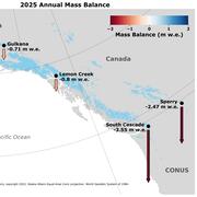
Sperry Glacier is located along the Continental Divide within Glacier National Park, Montana. It represents the midlatitude continental or transitional climate. Glacier observations began at this site in 2005.
Sperry Glacier occupies a broad, shallow cirque situated just beneath and west of the Continental Divide in the Lewis Mountain Range of Glacier National Park, Montana. This northeast facing glacier is wider than it is long relative to its flow direction and spans about 300 m in elevation with a median altitude of 2450 m. It ranks as a moderately sized glacier for this region, which contains the second highest concentration of glaciers in the U.S. Rocky Mountains. The glacier is in a ~4 km2 hanging cirque, and in 2014 it had an area of 0.80 km2, making Sperry Glacier the smallest of the benchmark glaciers.
Due to its position on the Continental Divide the glacier is influenced by both maritime and continental air masses. However, given its position on the western and predominantly windward side of the Continental Divide, Pacific storm systems dominate the weather. These bring heavy precipitation and moderate temperatures as warm, moist Pacific fronts collide with and lift over the Rocky Mountains. Temperature and precipitation patterns in northwest Montana are marked by strong altitudinal gradients. For valley sites at about 1000 m, mean temperatures for July, which is generally the warmest month of the year, are typically 15-17°C (59-63°F); they are roughly half that for mountain sites at 2500 m (Finklin, 1986). Annual precipitation averages 580 mm on the western and eastern edges of Glacier Park, but over 2500 mm at higher elevations in the Park's interior near the Continental Divide.
In 2005, the USGS Climate Change in Mountain Ecosystems (CCME) program established a glacier monitoring strategy in northwest Montana with the goal of assessing long-term changes to the region's glaciers. Through this monitoring program researchers also aimed to evaluate the hydrologic and ecologic effects of glaciers in Glacier National Park. Sperry Glacier was chosen as the benchmark study glacier due to its history of previous research, physical characteristics, and accessibility.
Researcher holds an ablation stake and winter snow probe during spring mass balance field work on Gulkana Glacier, AK.
Sperry became the focus of extensive field research starting in 2005 as scientists employed standard glaciological methods (Ostrem and Brugman, 1991) to estimate glacier-wide seasonal and annual surface mass balances. Snow depths and densities are measured in the spring when the glacier's balance is at a maximum. Ablation stakes are also installed at this time and then checked periodically during the summer melt season with a final check in early autumn at the balance minima. With similar goals and methodologies, the Sperry Glacier mass balance project joined the established USGS Benchmark Program in 2013. The addition of Sperry to the long-established mass balance monitoring projects in Alaska and Washington will facilitate a broader understanding of glacier dynamics, hydrology, and glacier response to climate change.
Direct field measurements are combined with weather data and imagery analyses to calculate the seasonal and annual mass balance of each glacier. Access all the data here.
Meteorologic
In June 2006 the Sperry Glacier weather station (48° 37' 24.1932" N, 113° 45' 53.4347" W) was installed at an altitude of 2450 m on a rocky outcrop about 100 m from the western edge of the glacier. Sensors measured air temperature, wind speed and direction, incoming solar radiation, and relative humidity. It became apparent that the 2 m mast height was not sufficient as the station was buried every winter and typically did not melt out until June. In some years the sensors were damaged so severely by snowpack creep that they needed replacing. During years with exceptionally heavy snowfall, such as in 2011, the station did not melt out until late July. The station was abandoned in 2012 due to these issues and there are no data for that year. But in 2013, the station was re-installed and recorded data for most of the June through September ablation season. In September 2014 a new station was installed in the same location with a 4 m mast and fitted with new instruments including a net radiometer, a new power system, and satellite telemetry. The taller mast should keep the sensors above the snowpack surface during the winter allowing the station to remain operational year round.
There are complete records of daily average temperature for the months July and August 2006-2011 and 2013. Most of the ablation on the glacier occurs during these two summer months. For the period of record, the mean July-August daily average temperature was 9.7° C (50° F) with a maximum daily average of 19.1° C (66° F) and minimum of -2.1° C (28° F). Precipitation at the glacier has not been measured directly. Snowfall is the dominant form of precipitation and usually accumulates starting in September or October and continues through May or June. The nearest weather station with precipitation data is the Flattop SNOTEL located 25 km northeast of and 530 m lower than the Sperry station. Average yearly precipitation here from the years 1980-2010 was 1.70 m (67 in). Snowpack measurements made in June when the glacier is near peak accumulation reveal precipitation is likely much higher on the glacier. Values of 2.50 meters (98 in) of snow water equivalent to 3.00 m (118 in) are common. However the accumulation patterns on Sperry are not fully understood and it is unclear what percentage of these deep snow packs owe their existence to precipitation versus how much snow is transported onto the glacier by wind and avalanches.
At this time, stream discharge for Sperry Glacier is not measured. The glacier's broad expanse creates numerous discreet runoff streams which make gauging this glacier a challenge. Runoff data are not available for this glacier.
From a hand-dug snow pit, a researcher samples cores of surface snow at Sperry Glacier to determine snow density, a measure needed to calculate glacier mass balance.
The glaciers of Glacier National Park have been the focus of visitor and scientific interest since before the park was established in 1910. Because it is relatively easy to access, Sperry Glacier has one of the most extensive records of historic data and measurement in the region. The earliest photo of the glacier dates back to 1894 and the earliest map was created in 1901. William Alden, a geologist for the USGS, explored the glacier and published the first scientific measurements and descriptions in the early 20th century (Alden, 1914; Alden, 1923). The glacier's retreat was documented by Dyson (1948) and the USGS and NPS conducted annual measurements of the glacier in the mid-20th century, including the installation of ablation stakes, measurements of flow speed and direction, and plane-table mapping that resulted in a detailed topographical map of the glacier with terminus locations from 1913-1969 (Johnson, 1980) (Reardon, et al, 2008). The progression of glacier retreat has been documented using satellite imagery and aerial photos (Key, et al., 2002), repeat photography, and annual GPS mapping of margins and terminus since 2003 by the USGS — CCME glacier monitoring program. Other parameters, such as depth measurement through the use of ice radar, GPS velocity measurements, and the determination of elevation profiles were included at the beginning of the monitoring program in 2005 in collaboration with Joel T. Harper of the University of Montana, Missoula.
Researchers get organized to begin mass balance field work after skiing to Sperry Glacier.
Sperry Glacier is a small alpine glacier located in Glacier National Park in the U.S. Rocky Mountains of Montana. It occupies a broad, shallow cirque along the Continental Divide which results in climatic influences from both maritime and continental air masses. Glaciers in this region have been decreasing in mass and extent during the 20th century in response to altered temperature and precipitation. Meltwater from these glaciers helps to regulate stream temperatures and maintains streamflow during late summer and drought periods when other sources are depleted. As glaciers disappear, summer stream temperatures will increase and may cause the local extinction of temperature sensitive aquatic insects, disrupting the basis of the aquatic food chain. Such changes in stream habitat may also have adverse effects for the threatened native bull trout and increase hybridization of native cutthroat trout, leaving the native population at risk. Loss of a sustained water source may impact vegetation communities and contribute to a dryer, more fire-prone landscape overall. Aside from these and other ecological consequences of losing glaciers, local economies and livelihoods are connected to glaciers in this region as well. Meltwater also contributes to agricultural practices and recreational uses like boating and fishing. Sperry, and the other remaining glaciers in Glacier National Park, also provide an aesthetic and historic component to the local tourism-based economy. The loss of glaciers in this region, and associated ecologic and socioeconomic contributions, are issues that scientists are exploring to assist land managers in determining adaptive strategies.
Hotaling, S, Clint C Muhlfeld, J Joseph Giersch, et al. 2018. Demographic modelling reveals a history of divergence with gene flow for a glacially tied stonefly in a changing post‐Pleistocene landscape. Journal of Biogeography 45: 304– 317, doi:10.1111/jbi.13125
Muhlfeld, Clint C, J. Joseph Giersch, F. Richard Hauer, Gregory T. Pederson, Gordon Luikart, Douglas P. Peterson, Christopher C. Downs, and Daniel B. Fagre, 2011, Climate change links fate of glaciers and an endemic alpine invertebrate. Climatic Change Letters. doi:10.1007/s10584-011-0057-1.
Mountain glaciers are dynamic reservoirs of frozen water, deeply interconnected with their surrounding ecosystems. Glacier change in North America has major societal impacts, including to water resources, natural hazard risk, tourism disruption, fisheries, and global sea level change. Understanding and quantifying precise connections between changing glaciers, the surrounding landscape and climate...
Mountain glaciers are dynamic reservoirs of frozen water, deeply interconnected with their surrounding ecosystems. Glacier change in North America has major societal impacts, including to water resources, natural hazard risk, tourism disruption, fisheries, and global sea level change. Understanding and quantifying precise connections between changing glaciers, the surrounding landscape and climate...
Nearly all of Earth's alpine glaciers are losing mass, with consequences for freshwater resources, landscape stability, regional ecosystems, and global sea level. Rates of glacier mass loss in Western North America and Alaska are among the highest on Earth (The GlaMBIE Team, 2025).
Nearly all of Earth's alpine glaciers are losing mass, with consequences for freshwater resources, landscape stability, regional ecosystems, and global sea level. Rates of glacier mass loss in Western North America and Alaska are among the highest on Earth (The GlaMBIE Team, 2025).
The USGS Glacier Project has conducted research beyond the Benchmark Glaciers, both past and present. This work has focused on infrastructure hazards, rapid glacier change, landscape destabilization, and glacier dynamics and processes not captured by the Benchmark Glacier network. These glaciers include Black Rapids, Kahiltna, Kennicott, Columbia, Hubbard, and Taku.
The USGS Glacier Project has conducted research beyond the Benchmark Glaciers, both past and present. This work has focused on infrastructure hazards, rapid glacier change, landscape destabilization, and glacier dynamics and processes not captured by the Benchmark Glacier network. These glaciers include Black Rapids, Kahiltna, Kennicott, Columbia, Hubbard, and Taku.
Wolverine Glacier is located in the high-latitude maritime climate regime of Alaska’s Kenai Mountains. Glacier observations began at this site in 1966.
Wolverine Glacier is located in the high-latitude maritime climate regime of Alaska’s Kenai Mountains. Glacier observations began at this site in 1966.
Gulkana Glacier is located in the high-latitude continental climate regime of Alaska’s Delta Mountains. Glacier observations began at this site in 1966 and continue through present as the northern most USGS Benchmark Glacier.
Gulkana Glacier is located in the high-latitude continental climate regime of Alaska’s Delta Mountains. Glacier observations began at this site in 1966 and continue through present as the northern most USGS Benchmark Glacier.
Lemon Creek Glacier is located in the high-latitude maritime region of Alaska, at the southernmost tip of the Juneau Icefield. Glacier observations began at this site in 1953.
Lemon Creek Glacier is located in the high-latitude maritime region of Alaska, at the southernmost tip of the Juneau Icefield. Glacier observations began at this site in 1953.
South Cascade Glacier is located in the midlatitude maritime climate of the North Cascade Mountains of Washington State. Glacier observations began at this site in 1958.
South Cascade Glacier is located in the midlatitude maritime climate of the North Cascade Mountains of Washington State. Glacier observations began at this site in 1958.
Scientist working on Sperry Glacier in Glacier National Park, Montana
Scientist working on Sperry Glacier in Glacier National Park, Montana. Sperry Glacier occupies a broad, shallow cirque situated just beneath and west of the Continental Divide in the Lewis Mountain Range of Glacier National Park, Montana. Due to its position on the Continental Divide the glacier is influenced by both maritime and continental air masses.
Scientist working on Sperry Glacier in Glacier National Park, Montana. Sperry Glacier occupies a broad, shallow cirque situated just beneath and west of the Continental Divide in the Lewis Mountain Range of Glacier National Park, Montana. Due to its position on the Continental Divide the glacier is influenced by both maritime and continental air masses.
From a hand-dug snow pit, a researcher samples cores of surface snow at Sperry Glacier to determine snow density, a measure needed to calculate glacier mass balance.
From a hand-dug snow pit, a researcher samples cores of surface snow at Sperry Glacier to determine snow density, a measure needed to calculate glacier mass balance.
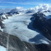
Aerial view of Sperry Glacier in Glacier National Park, Montana
Aerial view of Sperry Glacier in Glacier National Park, Montana. Sperry Glacier occupies a broad, shallow cirque situated just beneath and west of the Continental Divide in the Lewis Mountain Range of Glacier National Park, Montana. Due to its position on the Continental Divide the glacier is influenced by both maritime and continental air masses.
Aerial view of Sperry Glacier in Glacier National Park, Montana. Sperry Glacier occupies a broad, shallow cirque situated just beneath and west of the Continental Divide in the Lewis Mountain Range of Glacier National Park, Montana. Due to its position on the Continental Divide the glacier is influenced by both maritime and continental air masses.
Glaciers are important drivers of environmental heterogeneity and biological diversity across mountain landscapes. Worldwide, glaciers are receding rapidly due to climate change, with important consequences for biodiversity in mountain ecosystems. However, the effects of glacier loss on biodiversity have never been quantified across a mountainous region, primarily due to a lack of...
Authors
Clint C. Muhlfeld, Timothy Joseph Cline, J. Joseph Giersch, Erich H. Peitzsch, Caitlyn Florentine, Dean Jacobsen, Scott Hotaling
Glaciers are a key indicator of changing climate in the high mountain landscape. Glacier variations across a mountain range are ultimately driven by regional climate forcing. However, changes also reflect local, topographically driven processes such as snow avalanching, snow wind-drifting, and radiation shading as well as the initial glacier conditions such as hypsometry and ice...
Authors
Caitlyn Elizabeth Florentine, Joel T. Harper, Daniel B. Fagre
We reanalyzed mass balance records at Taku and Lemon Creek Glaciers to better understand the relative roles of hypsometry, local climate and dynamics as mass balance drivers. Over the 1946–2018 period, the cumulative mass balances diverged. Tidewater Taku Glacier advanced and gained mass at an average rate of +0.25±0.28 m w.e. a–1, contrasting with retreat and mass loss of –0.60±0.15 m w...
Authors
Christopher J. McNeil, Shad O’Neel, Michael Loso, Mauri Pelto, Louis C. Sass, Emily Baker, Seth Campbell
Currently, the volume of land ice on Earth is decreasing, driving consequential changes to global sea level and local stream habitat. Glacier retreat in Glacier National Park, Montana, U.S.A., is one example of land ice loss and glacier change. The U.S. Geological Survey Benchmark Glacier Project conducts glaciological research and collects field measurements across select North American...
Mountain glaciers integrate climate processes to provide an unmatched signal of regional climate forcing. However, extracting the climate signal via intercomparison of regional glacier mass balance records can be problematic when methods for extrapolating and calibrating direct glaciological measurements are mixed or inconsistent. To address this problem, we reanalyzed and compared long...
Authors
Shad O’Neel, Christopher J. McNeil, Louis C. Sass, Caitlyn Florentine, Emily Baker, Erich H. Peitzsch, Daniel McGrath, Andrew G. Fountain, Daniel B. Fagre
Glacial ice is a significant influence on local climate, hydrology, vegetation, and wildlife. We mapped a complete set of glacier areas from the Little Ice Age (LIA) using very high-resolution satellite imagery (30-cm) within Glacier National Park, a region that encompasses over 400,000 hectares. We measured glacier change across the park using LIA glacier area as a baseline and used...
There is significant uncertainty regarding the spatiotemporal distribution of seasonal snow on glaciers, despite being a fundamental component of glacier mass balance. To address this knowledge gap, we collected repeat, spatially extensive high-frequency ground-penetrating radar (GPR) observations on two glaciers in Alaska for five consecutive years. GPR measurements showed steep snow...
Authors
Daniel McGrath, Louis Sass, Shad O’Neel, Christopher J. McNeil, Salvatore G Candela, Emily Baker, Hans P. Marshall
Local topographically driven processes – such as wind drifting, avalanching, and shading – are known to alter the relationship between the mass balance of small cirque glaciers and regional climate. Yet partitioning such local effects from regional climate influence has proven difficult, creating uncertainty in the climate representativeness of some glaciers. We address this problem for...
Authors
Caitlyn Florentine, Joel T. Harper, Daniel B. Fagre, Johnnie Moore, Erich H. Peitzsch
Arctic river discharge has increased in recent decades although sources and mechanisms remain debated. Abundant literature documents permafrost thaw and mountain glacier shrinkage over the past decades. Here we link glacier runoff to aquifer recharge via a losing headwater stream in subarctic Interior Alaska. Field measurements in Jarvis Creek (634 km2), a subbasin of the Tanana and...
Authors
Anna K. Lilledahl, Anne Gadeke, Shad O’Neel, T. A. Gatesman, T. A. Douglas
Temperature and precipitation are key determinants of snowpack levels. Therefore, climate change is likely to affect the role of snow and ice in the landscapes and hydrology of the Chugach National Forest region. Downscaled climate projections developed by Scenarios Network for Alaska and Arctic Planning (SNAP) are useful for examining projected changes in snow at relatively fine...
Authors
Jeremy S. Littell, Stephanie A. McAfee, Shad O’Neel, Louis C. Sass, Evan Burgess, Steve Colt, Paul Clark
We analyzed glacier surface elevations (1957, 2010 and 2015) and surface mass-balance measurements (2008–2015) on the 30 km2 Eklutna Glacier, in the Chugach Mountains of southcentral Alaska. The geodetic mass balances from 1957 to 2010 and 2010 to 2015 are −0.52 ± 0.46 and −0.74 ± 0.10 m w.e. a−1, respectively. The glaciological mass balance of −0.73 m w.e. a−1 from 2010 to 2015 is
Authors
Louis C. Sass, Michael G. Loso, Jason Geck, Evan Thoms, Daniel Mcgrath
Glacier hypsometry provides a first‐order approach for assessing a glacier's response to climate forcings. We couple the Randolph Glacier Inventory to a suite of in situ observations and climate model output to examine potential change for the ∼27,000 glaciers in Alaska and northwest Canada through the end of the 21st century. By 2100, based on Representative Concentration Pathways (RCPs...
Authors
Daniel Mcgrath, Louis C. Sass, Shad O’Neel, Anthony A. Arendt, C. Kienholz
Sperry Glacier is located along the Continental Divide within Glacier National Park, Montana. It represents the midlatitude continental or transitional climate. Glacier observations began at this site in 2005.
Sperry Glacier occupies a broad, shallow cirque situated just beneath and west of the Continental Divide in the Lewis Mountain Range of Glacier National Park, Montana. This northeast facing glacier is wider than it is long relative to its flow direction and spans about 300 m in elevation with a median altitude of 2450 m. It ranks as a moderately sized glacier for this region, which contains the second highest concentration of glaciers in the U.S. Rocky Mountains. The glacier is in a ~4 km2 hanging cirque, and in 2014 it had an area of 0.80 km2, making Sperry Glacier the smallest of the benchmark glaciers.
Due to its position on the Continental Divide the glacier is influenced by both maritime and continental air masses. However, given its position on the western and predominantly windward side of the Continental Divide, Pacific storm systems dominate the weather. These bring heavy precipitation and moderate temperatures as warm, moist Pacific fronts collide with and lift over the Rocky Mountains. Temperature and precipitation patterns in northwest Montana are marked by strong altitudinal gradients. For valley sites at about 1000 m, mean temperatures for July, which is generally the warmest month of the year, are typically 15-17°C (59-63°F); they are roughly half that for mountain sites at 2500 m (Finklin, 1986). Annual precipitation averages 580 mm on the western and eastern edges of Glacier Park, but over 2500 mm at higher elevations in the Park's interior near the Continental Divide.
In 2005, the USGS Climate Change in Mountain Ecosystems (CCME) program established a glacier monitoring strategy in northwest Montana with the goal of assessing long-term changes to the region's glaciers. Through this monitoring program researchers also aimed to evaluate the hydrologic and ecologic effects of glaciers in Glacier National Park. Sperry Glacier was chosen as the benchmark study glacier due to its history of previous research, physical characteristics, and accessibility.
Researcher holds an ablation stake and winter snow probe during spring mass balance field work on Gulkana Glacier, AK.
Sperry became the focus of extensive field research starting in 2005 as scientists employed standard glaciological methods (Ostrem and Brugman, 1991) to estimate glacier-wide seasonal and annual surface mass balances. Snow depths and densities are measured in the spring when the glacier's balance is at a maximum. Ablation stakes are also installed at this time and then checked periodically during the summer melt season with a final check in early autumn at the balance minima. With similar goals and methodologies, the Sperry Glacier mass balance project joined the established USGS Benchmark Program in 2013. The addition of Sperry to the long-established mass balance monitoring projects in Alaska and Washington will facilitate a broader understanding of glacier dynamics, hydrology, and glacier response to climate change.
Direct field measurements are combined with weather data and imagery analyses to calculate the seasonal and annual mass balance of each glacier. Access all the data here.
Meteorologic
In June 2006 the Sperry Glacier weather station (48° 37' 24.1932" N, 113° 45' 53.4347" W) was installed at an altitude of 2450 m on a rocky outcrop about 100 m from the western edge of the glacier. Sensors measured air temperature, wind speed and direction, incoming solar radiation, and relative humidity. It became apparent that the 2 m mast height was not sufficient as the station was buried every winter and typically did not melt out until June. In some years the sensors were damaged so severely by snowpack creep that they needed replacing. During years with exceptionally heavy snowfall, such as in 2011, the station did not melt out until late July. The station was abandoned in 2012 due to these issues and there are no data for that year. But in 2013, the station was re-installed and recorded data for most of the June through September ablation season. In September 2014 a new station was installed in the same location with a 4 m mast and fitted with new instruments including a net radiometer, a new power system, and satellite telemetry. The taller mast should keep the sensors above the snowpack surface during the winter allowing the station to remain operational year round.
There are complete records of daily average temperature for the months July and August 2006-2011 and 2013. Most of the ablation on the glacier occurs during these two summer months. For the period of record, the mean July-August daily average temperature was 9.7° C (50° F) with a maximum daily average of 19.1° C (66° F) and minimum of -2.1° C (28° F). Precipitation at the glacier has not been measured directly. Snowfall is the dominant form of precipitation and usually accumulates starting in September or October and continues through May or June. The nearest weather station with precipitation data is the Flattop SNOTEL located 25 km northeast of and 530 m lower than the Sperry station. Average yearly precipitation here from the years 1980-2010 was 1.70 m (67 in). Snowpack measurements made in June when the glacier is near peak accumulation reveal precipitation is likely much higher on the glacier. Values of 2.50 meters (98 in) of snow water equivalent to 3.00 m (118 in) are common. However the accumulation patterns on Sperry are not fully understood and it is unclear what percentage of these deep snow packs owe their existence to precipitation versus how much snow is transported onto the glacier by wind and avalanches.
At this time, stream discharge for Sperry Glacier is not measured. The glacier's broad expanse creates numerous discreet runoff streams which make gauging this glacier a challenge. Runoff data are not available for this glacier.
From a hand-dug snow pit, a researcher samples cores of surface snow at Sperry Glacier to determine snow density, a measure needed to calculate glacier mass balance.
The glaciers of Glacier National Park have been the focus of visitor and scientific interest since before the park was established in 1910. Because it is relatively easy to access, Sperry Glacier has one of the most extensive records of historic data and measurement in the region. The earliest photo of the glacier dates back to 1894 and the earliest map was created in 1901. William Alden, a geologist for the USGS, explored the glacier and published the first scientific measurements and descriptions in the early 20th century (Alden, 1914; Alden, 1923). The glacier's retreat was documented by Dyson (1948) and the USGS and NPS conducted annual measurements of the glacier in the mid-20th century, including the installation of ablation stakes, measurements of flow speed and direction, and plane-table mapping that resulted in a detailed topographical map of the glacier with terminus locations from 1913-1969 (Johnson, 1980) (Reardon, et al, 2008). The progression of glacier retreat has been documented using satellite imagery and aerial photos (Key, et al., 2002), repeat photography, and annual GPS mapping of margins and terminus since 2003 by the USGS — CCME glacier monitoring program. Other parameters, such as depth measurement through the use of ice radar, GPS velocity measurements, and the determination of elevation profiles were included at the beginning of the monitoring program in 2005 in collaboration with Joel T. Harper of the University of Montana, Missoula.
Researchers get organized to begin mass balance field work after skiing to Sperry Glacier.
Sperry Glacier is a small alpine glacier located in Glacier National Park in the U.S. Rocky Mountains of Montana. It occupies a broad, shallow cirque along the Continental Divide which results in climatic influences from both maritime and continental air masses. Glaciers in this region have been decreasing in mass and extent during the 20th century in response to altered temperature and precipitation. Meltwater from these glaciers helps to regulate stream temperatures and maintains streamflow during late summer and drought periods when other sources are depleted. As glaciers disappear, summer stream temperatures will increase and may cause the local extinction of temperature sensitive aquatic insects, disrupting the basis of the aquatic food chain. Such changes in stream habitat may also have adverse effects for the threatened native bull trout and increase hybridization of native cutthroat trout, leaving the native population at risk. Loss of a sustained water source may impact vegetation communities and contribute to a dryer, more fire-prone landscape overall. Aside from these and other ecological consequences of losing glaciers, local economies and livelihoods are connected to glaciers in this region as well. Meltwater also contributes to agricultural practices and recreational uses like boating and fishing. Sperry, and the other remaining glaciers in Glacier National Park, also provide an aesthetic and historic component to the local tourism-based economy. The loss of glaciers in this region, and associated ecologic and socioeconomic contributions, are issues that scientists are exploring to assist land managers in determining adaptive strategies.
Hotaling, S, Clint C Muhlfeld, J Joseph Giersch, et al. 2018. Demographic modelling reveals a history of divergence with gene flow for a glacially tied stonefly in a changing post‐Pleistocene landscape. Journal of Biogeography 45: 304– 317, doi:10.1111/jbi.13125
Muhlfeld, Clint C, J. Joseph Giersch, F. Richard Hauer, Gregory T. Pederson, Gordon Luikart, Douglas P. Peterson, Christopher C. Downs, and Daniel B. Fagre, 2011, Climate change links fate of glaciers and an endemic alpine invertebrate. Climatic Change Letters. doi:10.1007/s10584-011-0057-1.
Mountain glaciers are dynamic reservoirs of frozen water, deeply interconnected with their surrounding ecosystems. Glacier change in North America has major societal impacts, including to water resources, natural hazard risk, tourism disruption, fisheries, and global sea level change. Understanding and quantifying precise connections between changing glaciers, the surrounding landscape and climate...
Mountain glaciers are dynamic reservoirs of frozen water, deeply interconnected with their surrounding ecosystems. Glacier change in North America has major societal impacts, including to water resources, natural hazard risk, tourism disruption, fisheries, and global sea level change. Understanding and quantifying precise connections between changing glaciers, the surrounding landscape and climate...
Nearly all of Earth's alpine glaciers are losing mass, with consequences for freshwater resources, landscape stability, regional ecosystems, and global sea level. Rates of glacier mass loss in Western North America and Alaska are among the highest on Earth (The GlaMBIE Team, 2025).
Nearly all of Earth's alpine glaciers are losing mass, with consequences for freshwater resources, landscape stability, regional ecosystems, and global sea level. Rates of glacier mass loss in Western North America and Alaska are among the highest on Earth (The GlaMBIE Team, 2025).
The USGS Glacier Project has conducted research beyond the Benchmark Glaciers, both past and present. This work has focused on infrastructure hazards, rapid glacier change, landscape destabilization, and glacier dynamics and processes not captured by the Benchmark Glacier network. These glaciers include Black Rapids, Kahiltna, Kennicott, Columbia, Hubbard, and Taku.
The USGS Glacier Project has conducted research beyond the Benchmark Glaciers, both past and present. This work has focused on infrastructure hazards, rapid glacier change, landscape destabilization, and glacier dynamics and processes not captured by the Benchmark Glacier network. These glaciers include Black Rapids, Kahiltna, Kennicott, Columbia, Hubbard, and Taku.
Wolverine Glacier is located in the high-latitude maritime climate regime of Alaska’s Kenai Mountains. Glacier observations began at this site in 1966.
Wolverine Glacier is located in the high-latitude maritime climate regime of Alaska’s Kenai Mountains. Glacier observations began at this site in 1966.
Gulkana Glacier is located in the high-latitude continental climate regime of Alaska’s Delta Mountains. Glacier observations began at this site in 1966 and continue through present as the northern most USGS Benchmark Glacier.
Gulkana Glacier is located in the high-latitude continental climate regime of Alaska’s Delta Mountains. Glacier observations began at this site in 1966 and continue through present as the northern most USGS Benchmark Glacier.
Lemon Creek Glacier is located in the high-latitude maritime region of Alaska, at the southernmost tip of the Juneau Icefield. Glacier observations began at this site in 1953.
Lemon Creek Glacier is located in the high-latitude maritime region of Alaska, at the southernmost tip of the Juneau Icefield. Glacier observations began at this site in 1953.
South Cascade Glacier is located in the midlatitude maritime climate of the North Cascade Mountains of Washington State. Glacier observations began at this site in 1958.
South Cascade Glacier is located in the midlatitude maritime climate of the North Cascade Mountains of Washington State. Glacier observations began at this site in 1958.
Scientist working on Sperry Glacier in Glacier National Park, Montana
Scientist working on Sperry Glacier in Glacier National Park, Montana. Sperry Glacier occupies a broad, shallow cirque situated just beneath and west of the Continental Divide in the Lewis Mountain Range of Glacier National Park, Montana. Due to its position on the Continental Divide the glacier is influenced by both maritime and continental air masses.
Scientist working on Sperry Glacier in Glacier National Park, Montana. Sperry Glacier occupies a broad, shallow cirque situated just beneath and west of the Continental Divide in the Lewis Mountain Range of Glacier National Park, Montana. Due to its position on the Continental Divide the glacier is influenced by both maritime and continental air masses.
From a hand-dug snow pit, a researcher samples cores of surface snow at Sperry Glacier to determine snow density, a measure needed to calculate glacier mass balance.
From a hand-dug snow pit, a researcher samples cores of surface snow at Sperry Glacier to determine snow density, a measure needed to calculate glacier mass balance.
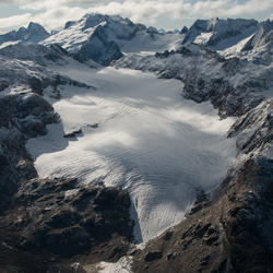
Aerial view of Sperry Glacier in Glacier National Park, Montana
Aerial view of Sperry Glacier in Glacier National Park, Montana. Sperry Glacier occupies a broad, shallow cirque situated just beneath and west of the Continental Divide in the Lewis Mountain Range of Glacier National Park, Montana. Due to its position on the Continental Divide the glacier is influenced by both maritime and continental air masses.
Aerial view of Sperry Glacier in Glacier National Park, Montana. Sperry Glacier occupies a broad, shallow cirque situated just beneath and west of the Continental Divide in the Lewis Mountain Range of Glacier National Park, Montana. Due to its position on the Continental Divide the glacier is influenced by both maritime and continental air masses.
Glaciers are important drivers of environmental heterogeneity and biological diversity across mountain landscapes. Worldwide, glaciers are receding rapidly due to climate change, with important consequences for biodiversity in mountain ecosystems. However, the effects of glacier loss on biodiversity have never been quantified across a mountainous region, primarily due to a lack of...
Authors
Clint C. Muhlfeld, Timothy Joseph Cline, J. Joseph Giersch, Erich H. Peitzsch, Caitlyn Florentine, Dean Jacobsen, Scott Hotaling
Glaciers are a key indicator of changing climate in the high mountain landscape. Glacier variations across a mountain range are ultimately driven by regional climate forcing. However, changes also reflect local, topographically driven processes such as snow avalanching, snow wind-drifting, and radiation shading as well as the initial glacier conditions such as hypsometry and ice...
Authors
Caitlyn Elizabeth Florentine, Joel T. Harper, Daniel B. Fagre
We reanalyzed mass balance records at Taku and Lemon Creek Glaciers to better understand the relative roles of hypsometry, local climate and dynamics as mass balance drivers. Over the 1946–2018 period, the cumulative mass balances diverged. Tidewater Taku Glacier advanced and gained mass at an average rate of +0.25±0.28 m w.e. a–1, contrasting with retreat and mass loss of –0.60±0.15 m w...
Authors
Christopher J. McNeil, Shad O’Neel, Michael Loso, Mauri Pelto, Louis C. Sass, Emily Baker, Seth Campbell
Currently, the volume of land ice on Earth is decreasing, driving consequential changes to global sea level and local stream habitat. Glacier retreat in Glacier National Park, Montana, U.S.A., is one example of land ice loss and glacier change. The U.S. Geological Survey Benchmark Glacier Project conducts glaciological research and collects field measurements across select North American...
Mountain glaciers integrate climate processes to provide an unmatched signal of regional climate forcing. However, extracting the climate signal via intercomparison of regional glacier mass balance records can be problematic when methods for extrapolating and calibrating direct glaciological measurements are mixed or inconsistent. To address this problem, we reanalyzed and compared long...
Authors
Shad O’Neel, Christopher J. McNeil, Louis C. Sass, Caitlyn Florentine, Emily Baker, Erich H. Peitzsch, Daniel McGrath, Andrew G. Fountain, Daniel B. Fagre
Glacial ice is a significant influence on local climate, hydrology, vegetation, and wildlife. We mapped a complete set of glacier areas from the Little Ice Age (LIA) using very high-resolution satellite imagery (30-cm) within Glacier National Park, a region that encompasses over 400,000 hectares. We measured glacier change across the park using LIA glacier area as a baseline and used...
There is significant uncertainty regarding the spatiotemporal distribution of seasonal snow on glaciers, despite being a fundamental component of glacier mass balance. To address this knowledge gap, we collected repeat, spatially extensive high-frequency ground-penetrating radar (GPR) observations on two glaciers in Alaska for five consecutive years. GPR measurements showed steep snow...
Authors
Daniel McGrath, Louis Sass, Shad O’Neel, Christopher J. McNeil, Salvatore G Candela, Emily Baker, Hans P. Marshall
Local topographically driven processes – such as wind drifting, avalanching, and shading – are known to alter the relationship between the mass balance of small cirque glaciers and regional climate. Yet partitioning such local effects from regional climate influence has proven difficult, creating uncertainty in the climate representativeness of some glaciers. We address this problem for...
Authors
Caitlyn Florentine, Joel T. Harper, Daniel B. Fagre, Johnnie Moore, Erich H. Peitzsch
Arctic river discharge has increased in recent decades although sources and mechanisms remain debated. Abundant literature documents permafrost thaw and mountain glacier shrinkage over the past decades. Here we link glacier runoff to aquifer recharge via a losing headwater stream in subarctic Interior Alaska. Field measurements in Jarvis Creek (634 km2), a subbasin of the Tanana and...
Authors
Anna K. Lilledahl, Anne Gadeke, Shad O’Neel, T. A. Gatesman, T. A. Douglas
Temperature and precipitation are key determinants of snowpack levels. Therefore, climate change is likely to affect the role of snow and ice in the landscapes and hydrology of the Chugach National Forest region. Downscaled climate projections developed by Scenarios Network for Alaska and Arctic Planning (SNAP) are useful for examining projected changes in snow at relatively fine...
Authors
Jeremy S. Littell, Stephanie A. McAfee, Shad O’Neel, Louis C. Sass, Evan Burgess, Steve Colt, Paul Clark
We analyzed glacier surface elevations (1957, 2010 and 2015) and surface mass-balance measurements (2008–2015) on the 30 km2 Eklutna Glacier, in the Chugach Mountains of southcentral Alaska. The geodetic mass balances from 1957 to 2010 and 2010 to 2015 are −0.52 ± 0.46 and −0.74 ± 0.10 m w.e. a−1, respectively. The glaciological mass balance of −0.73 m w.e. a−1 from 2010 to 2015 is
Authors
Louis C. Sass, Michael G. Loso, Jason Geck, Evan Thoms, Daniel Mcgrath
Glacier hypsometry provides a first‐order approach for assessing a glacier's response to climate forcings. We couple the Randolph Glacier Inventory to a suite of in situ observations and climate model output to examine potential change for the ∼27,000 glaciers in Alaska and northwest Canada through the end of the 21st century. By 2100, based on Representative Concentration Pathways (RCPs...
Authors
Daniel Mcgrath, Louis C. Sass, Shad O’Neel, Anthony A. Arendt, C. Kienholz