
Video Description – October 2024 to September 2025
Images
Images intro.
Filter Total Items: 47
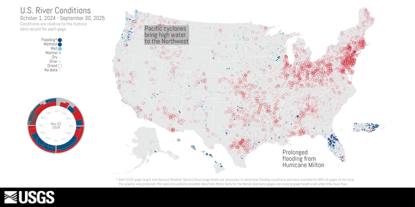
U.S. River Conditions for Water Year 2025
Video Description – October 2024 to September 2025
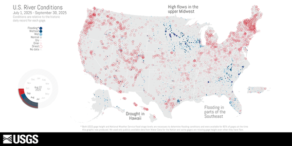
U.S. River Conditions, July to September 2025
U.S. River Conditions, July to September 2025 thumbnail image. The river conditions shown range from the driest condition seen at a gage (red open circles) to the wettest (blue closed circles). A purple outer ring around a gage indicates it is flooding.
U.S. River Conditions, July to September 2025 thumbnail image. The river conditions shown range from the driest condition seen at a gage (red open circles) to the wettest (blue closed circles). A purple outer ring around a gage indicates it is flooding.

USGS water experts measure floodwaters at Green River in Munfordville, KY
USGS water experts measure floodwaters at Green River in Munfordville, KYUSGS water experts Logan VanWatermulen and Shawn LeMaster measure how high and fast floodwaters move at Green River in Munfordville, KY on February 17. This real-time data is used by emergency managers to help protect lives and property. The Green River streamgage has been collecting data since 1915 and is funded by the U.S. Army Corps of Engineers and USGS.

Thumbnail for U.S. River Conditions Jan-Mar 2023
U.S. River Conditions from January 1, 2023 to March 31, 2023 at @USGS #streamgages 💧
River conditions range from driest conditions at a gage (red open circles) to the wettest (blue closed circles). A purple outer ring indicates flooding.
U.S. River Conditions from January 1, 2023 to March 31, 2023 at @USGS #streamgages 💧
River conditions range from driest conditions at a gage (red open circles) to the wettest (blue closed circles). A purple outer ring indicates flooding.

Streamgage repair on Bowlegs Creek near Ft. Meade, FL (02295013)
Streamgage repair on Bowlegs Creek near Ft. Meade, FL (02295013)Streamgage repair at Bowlegs Creek near Ft. Meade, FL (02295013) after being submerged by flooding from Hurricane Ian. The site is used to monitor water levels and compute discharge in coorporation with Southwest Florida Water Management District.

Streamgage repair on Bowlegs Creek near Ft. Meade, Florida (02295013)
Streamgage repair on Bowlegs Creek near Ft. Meade, Florida (02295013)Hydrologic Technician, Erik Ohlson, repairs a streamgage at Bowlegs Creek near Ft. Meade, Florida (02295013) after it was submerged by flooding from Hurricane Ian. The site is used to monitor water levels and compute discharge in cooperation with Southwest Florida Water Management District.

Before and After of the site at Rio Del La Plata blw Represa Comerio, Puerto Rico (50044210), following Hurricane Fiona
Before and After of the site at Rio Del La Plata blw Represa Comerio, Puerto Rico (50044210), following Hurricane FionaA before-and after comparison of the water level and precipitation at the site located at Rio Del La Plata blw Represa Comerio, Puerto Rico (50044210), illustrating the damage from Hurricane Fiona. The photo on the left was taken on July 11, 2022 when the site was installed. The photo on the right was taken on Sept. 20, 2022 after Hurricane Fiona.

Pack Creek at Pack Creek Road Bridge river gage
Photo looking downstream from the Pack Creek Road Bridge shows the rain gage on top with a USGS sticker. Below is a solar panel for power. The other white round object contains the data logger and satellite antenna.
Photo looking downstream from the Pack Creek Road Bridge shows the rain gage on top with a USGS sticker. Below is a solar panel for power. The other white round object contains the data logger and satellite antenna.

USGS measures spring flooding at Chesapeake bay's largest tributary
USGS measures spring flooding at Chesapeake bay's largest tributaryA USGS field team, to include Pat Bowen, Kate Bowen and John Trainor, uses specialized equipment to measure spring floodwaters at Chesapeake Bay's largest tributary, the Susquehanna River in Maryland.

USGS measures floodwaters off a cableway in New York
USGS measures floodwaters off a cableway in New YorkUSGS hydrologist Ken McGrath measures floodwaters off a cableway on Schoharie Creek in North Blenheim, New York.
USGS measures floodwaters off a cableway in New York
USGS measures floodwaters off a cableway in New YorkUSGS hydrologist Ken McGrath measures floodwaters off a cableway on Schoharie Creek in North Blenheim, New York.

USGS Responds to Spring Flooding in Minnesota
On April 10, USGS hydrographer Josh Sundberg measures Red River water flowing over the road in East Grand Forks, Minnesota as flood protection walls prevent further flooding.
On April 10, USGS hydrographer Josh Sundberg measures Red River water flowing over the road in East Grand Forks, Minnesota as flood protection walls prevent further flooding.

USGS Responds to Spring Flooding in North Dakota
On April 6, USGS hydrographer Spencer Wheeling carries equipment out to measure high water on the Tongue River near Akra, North Dakota.
On April 6, USGS hydrographer Spencer Wheeling carries equipment out to measure high water on the Tongue River near Akra, North Dakota.

USGS Responds to Spring Flooding in North Dakota
USGS hydrographer Chris Broz gets on the cold ground to measure the high-water mark of the Pembina River at Neche, North Dakota.
USGS hydrographer Chris Broz gets on the cold ground to measure the high-water mark of the Pembina River at Neche, North Dakota.

USGS Responds to Spring Flooding in North Dakota
USGS hydrographer Spencer Wheeling gets equipment ready to collect a flood water-quality sample on the Wild Rice River near St.
USGS hydrographer Spencer Wheeling gets equipment ready to collect a flood water-quality sample on the Wild Rice River near St.

USGS Responds to Spring Flooding in North Dakota
USGS hydrographer Brent Hanson wades out in freezing waters to collect flood measurements on the Sheyenne River near Cooperstown, North Dakota. Hanson reads an outside staff, which is a vertical graduated ruler used to calibrate the continuous readings of water level provided by electronic sensors.
USGS hydrographer Brent Hanson wades out in freezing waters to collect flood measurements on the Sheyenne River near Cooperstown, North Dakota. Hanson reads an outside staff, which is a vertical graduated ruler used to calibrate the continuous readings of water level provided by electronic sensors.

USGS Responds to Spring Flooding in North Dakota
A frozen USGS rapid deployment streamgage measures the height of the Maple River near Page, North Dakota. RDGs can be installed on short notice to provide additional information at locations that are normally not gauged.
A frozen USGS rapid deployment streamgage measures the height of the Maple River near Page, North Dakota. RDGs can be installed on short notice to provide additional information at locations that are normally not gauged.

Spring 2019 Flooding - Wild Rice River in Minnesota
Spring 2019 Flooding - Wild Rice River in MinnesotaWWG Reading on the Wild Rice River in Minnesota during record Midwest flooding in spring 2019.
Spring 2019 Flooding - Wild Rice River in Minnesota
Spring 2019 Flooding - Wild Rice River in MinnesotaWWG Reading on the Wild Rice River in Minnesota during record Midwest flooding in spring 2019.

Spring 2019 Flooding - Big Sioux River, Akron, IA
After record flooding on the Big Sioux River, USGS crews mobilized to take important water measurements.
After record flooding on the Big Sioux River, USGS crews mobilized to take important water measurements.

Spring 2019 Flooding - Big Sioux River
After record flooding on the Big Sioux River, USGS crews mobilized to take important water measurements.
After record flooding on the Big Sioux River, USGS crews mobilized to take important water measurements.