
3DNTM Data Collaboration Announcement (DCA) Frequently Asked Questions (FAQ)
A list of Q&As filling common knowledge gaps. FAQs will be updated regularly.
► last refreshed: September 15, 2025
Project Submissions | Funding | Geographic Areas of Interest (AOI) and Project Information | Technical, Lidar Base Specifications, Lidar Products and Services, Non-Conventional Technologies
1.0 Project Submissions
1.01 What are the Fiscal Year (FY) 2026 DCA Due Dates?
- The FY26 DCA was released on August 6, 2025.
- The initial due date for project submissions was 5 pm ET September 12, 2025.
- Project submissions received after the deadline will be considered for review after the initial project selection is complete and until no remaining FY26 funds are available for obligation.
1.02 When is the annual public DCA informational webinar and are the slides available?
The FY26 3DNTM DCA Informational Webinar was held on August 6, 2025. The slides are not available for download. A recording of the presentation is available on the DCA Portal.
1.03 What application materials are required and where can I find them? Do you have a link to a full sample project submission and associated deliverables?
There is not a sample application package available. Applicants can find instructions and required materials on the current fiscal year pages linked at the DCA Portal. Application materials are available as soon as the DCA is released. You can find descriptions of past projects that have been selected for funding on the 3DNTM DCA Portal.

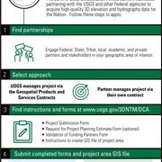
The DCA Participation Process is four steps: (1) Find Partnerships, (2) Select Project Approach, (3) Gather Project Submission Materials, (4) Submit Completed Materials
Required materials for a 3DEP or 3DHP DCA project submission include:
- Form 3DEP-A or 3DHP-A: DCA Project Summary Form
- Form 3DEP-D or 3DHP-D: Validation of Proposed Funding Partners for each funding partner
- Vector GIS file defining the coverage area of the project submission represented by a polygon in shapefile, GeoPackage, or KML/KMZ format. See Form 3DEP-B or 3DHP-B for instructions.
Instructions regarding additional information that may be required for selected financial assistance projects will be provided after project selection.
1.04 How do I submit my project for consideration?
- Submit completed application materials as email attachments to 3dep_dca@usgs.gov or 3dhp_dca@usgs.gov. Detailed instructions are available on the DCA Portal.
- It is very important that the project submission email indicates which part of this DCA is being submitted to (i.e., 3DEP or 3DHP).
- Project submissions to the FY26 DCA should not include co-collected topographic and bathymetric lidar.
- Joint 3DEP-3DHP applications or applications for simultaneous data acquisition of 3DEP and 3DHP will not be accepted.
**View the Navigate the DCA infographic for a step-by-step overview of the Data Collaboration Announcement application process.
1.05 After submitting a project, what type of confirmation does the applicant receive to know that the submission has been received?
Applicants will submit projects via email regardless of the data acquisition approach they choose (GPSC or financial assistance) and will receive an email confirmation of their submission, generally within 1 week of the date of submission.
1.06 Can an applicant submit more than one DCA project?
Yes, an applicant can submit multiple applications. There is no limit to how many applications can be submitted. Reminder, joint 3DEP-3DHP applications or applications for simultaneous data acquisition of 3DEP and 3DHP will not be accepted.
1.07 Should we use multiple submissions for large regional projects?
If the project is made of noncontiguous areas or hydrologic units (HU) that are separated by large expanses, it is advised to split into more than one application. If the proposed project is a contiguous area it is recommended to submit as one application unless the total acquisition cost is over 5 million dollars for 3DEP or over 3 million dollars for 3DHP. If the total acquisition cost will exceed these guidelines, it is recommended to split the application into multiple submissions. There is no limit to how many applications can be submitted.
1.08 How would a request for a multi-year project be presented in a DCA application?
The DCA only accepts submissions for single-year funding. Partners are encouraged to reference multi-year plans where applicable. For example, including information like “this submission is requesting funding for phase 1 of a 3-year plan” or include a link to a website that includes information about your multi-year goals and objectives. This information should be included in the Project Summary and/or Additional Project Details or Clarifications sections of Form 3DEP-A or 3DHP-A.
1.09 What is the benefit of partnering with the 3D Elevation or 3D Hydrography Program?
Both 3DEP and 3DHP are partnership-driven programs that provide consistent, high-quality, publicly available, application-ready topographic data that spans project and jurisdictional boundaries. There are numerous benefits to partnering with 3DEP or 3DHP, including:
- A cost-share process that allows project funds from federal, state, local, tribal, non-profit, and private partners to be leveraged toward large data collections - reducing acquisition costs by as much as 25%.
- An end-to-end data acquisition and publication process that allows partners to concentrate on their business activities and mission rather than managing internal data acquisitions.
- Data validation processes and controls that ensure delivery of consistent, high quality topographic data products that adhere to published specifications.
- A process that ensures data will be placed in the public domain for the benefit of all, with a goal to eliminate unnecessary and wasteful duplicate data collection.
1.10 Does a small county or Hydrologic Unit (HU) project have a chance at being selected?
For 3DEP, the purpose of the DCA is to help achieve the 3DEP goal of nationwide coverage of high-resolution elevation data. To accomplish this goal, the USGS prefers to fund lidar surveys over a relatively large area to achieve economies of scale. Currently, the minimum preferred project size is 1,500 square miles, but smaller projects are considered on a case-by-case basis:
- To fill gaps in coverage.
- Where the project area of interest (AOI) defines a complete physical (such as a watershed) or political (such as a county) unit.
- For projects that represent significant cost share by the applicant.
- When the proposed acquisition covers an area over which significant changes to the landscape have occurred.
We encourage you to work with surrounding counties to gauge interest in a regional acquisition to achieve economies of scale but also encourage you to submit an application. The DCA has, in the past, supported several projects under 500 square miles.
For 3DHP, the DCA will help USGS to provide the first systematic update of the nation’s hydrography data in several decades. Data for 3DHP must be collected by whole hydrologic units (HU) from the Watershed Boundary Dataset (WBD). Project areas cannot be clipped to a political boundary except where the project is adjacent to the US-Canada or -Mexico border or to remove areas of open water where a HU extends to the NOAA 3 Nautical Mile Line or in bays, estuaries, and sounds. USGS prefers to fund hydrography data acquisition for whole 8-digit HU or large-area collections of 10-digit HU to realize economies of scale. Smaller projects or projects made up of 12-digit HU will be considered on a limited case-by-case basis:
- To fill gaps in coverage.
- For projects that represent significant cost share by the applicant.
1.11 Is there a published evaluation process?
Project submissions will be reviewed considering the overall value and benefit to the government. Considerations will include project location and areal extent of proposed data acquisition, cost realism, cost share (i.e., funds contributed by the applicant), the maturity of applicant’s project submission, and the technical approach and past performance as applicable and related to the project submission. Considerations specific to 3DEP or 3DHP are available from the DCA Portal.
1.12 Is the age of existing lidar an evaluation consideration for submitted 3DEP projects?
The age of existing 3DEP lidar will be considered for DCA project submissions for areas:
- Where data are 5 or more years old (8 years or more in Alaska, Hawaii, and US Territories) as defined in 3DEP-G FY26 Consolidated Federal Priority Acquisition Areas.
- Where significant changes to the landscape have occurred and is documented in the project submission. Examples of significant changes to the landscape include urban development or natural disasters (e.g., flooding, hurricane, and wildfire).
1.13 Is it necessary to complete past performance if you plan to submit a project using GPSC?
Applicants choosing to make use of the services of the Geospatial Products and Services (GPSC) Suite of Contracts do not need to complete the Technical Evaluation component of Form 3DEP-A or Form 3DHP-A. They also do not need to make any references to a data acquisition vendor in the Past Performance Section of the Project Submission Forms. As appropriate, however, applicants may wish to include information on their ability to manage large data acquisition projects with multiple partners or work with their funding authority to secure and commit the funding.
1.14 Who can be a contractor?
GPSC-selected firms are listed on the Geospatial Products and Services Contracts webpage. For Financial Assistance projects, there is no requirement to use a GPSC contractor, but there is the expectation that the data will meet USGS specifications.
1.15 For DCA applicants selecting the Geospatial Products and Services Contracts (GPSC) project approach, if a preferred vendor is specified in the application does this guarantee that the vendor will win the project? Where specifically in the DCA application should the preferred vendor be listed?
If a GPSC contractor has participated in the planning or partnership coordination of the project submission, applicants can identify that contractor as a suggested source (preferred vendor/contractor). USGS is not obligated to award the project to the preferred vendor. USGS’s selection of a vendor for any given project is based on several factors designed to result in successful completion of the project on behalf of the funding partners.
If a GPSC contractor is identified as a preferred vendor, the selection can be included in Form 3DEP-A or Form 3DHP-A: Project Summary Form under Suggested Source and Rationale for Suggested Source. Identification of a selected source is not mandatory, but if one is identified, a rationale for the selection is required including how the contractor has participated in the planning or partnership of the project and their IDIQ number. Only one GPSC contractor should be identified. If more than one GPSC contractor is identified the suggested source will be invalidated.
1.16 Will the USGS include Tidal Coordination in their Project Planning Estimate for 3DEP?
If an applicant has a requirement for 3DEP tidal coordination, the requirement should be noted in Form 3DEP-A under Additional Collection Conditions and/or Products and Services. The cost of any additional products and services, including tidal coordination, should not be included in the 3DEP funding request but can be noted in the Additional Project Details section. Only the cost for acquisition and standard 3DEP deliverables as defined in the current 3DEP Lidar Base Specification should be included in the funding table. The cost of additional products and services are the sole responsibility of the applicant and will be incorporated into partner funding agreement(s). 3DEP will not contribute funding toward additional products and services.
For those utilizing Form 3DEP-C to secure a project planning estimate, the form provides an opportunity for you to note a requirement for tidal coordination. Please keep in mind that coastal tidal coordination requires preplanning and will increase project costs depending upon degree of coordination, size of project, number of tidal stations to be referenced, water level to be attained, and other considerations. Tidal coordination requirements should be noted as early in the project planning phase as possible.
1.17 Does collection have to be in the fall? Can it be in the summer?
Acquisition is not required to be completed in the spring or fall. 3DEP prefers leaf-off and snow-free environmental conditions; however, we can work with applicants for their desired season including leaf-on acquisitions. 3DHP does not have a specific data acquisition season.
1.18 If a 3DEP project is planned for the upcoming winter season, will submitting a project early result in an earlier approval/denial notification?
The 3DEP team will not begin evaluation of project submissions until after the submission deadline has passed. The project submission window is not considered during evaluation; HOWEVER once evaluation is complete, the USGS will notify those applicants with time-sensitive submissions as early as possible in the notification cycle. It is important to note that final project acceptance is based on the availability of funding.
1.19 Can a 3DEP DCA financial assistance project submission request funding from the current/upcoming DCA to collect data for the following winter leaf-off season?
If feasible, you should consider postponing your submission until the next DCA cycle. If not feasible, please move forward with the submission and include details and a justification in the “Additional Project Details or Clarifications” box of Form 3DEP-A: Project Summary Form. If necessary, the USGS evaluation team will ask clarifying questions during project evaluation.
1.20 Is there any way to ensure that projects are awarded in time to permit 3DEP data acquisition during the spring season or the current winter season? Some state partners have trouble spanning state fiscal years.
It may be possible; however, there are several considerations and caveats:
DCA awards are based on the availability of funding in any given fiscal year (FY). The USGS must have the authority to allocate funding to DCA projects before any awards can be made. USGS authority is based on federal appropriations. The federal FY begins on October 1. If Congress fails to pass a full and final budget before October 1, the government will be operating under a Continuing Resolution (CR). Spending under a CR is restricted, limiting our ability to issue DCA awards.
Exact timelines may vary, but the USGS will evaluate all project submissions shortly after the submission deadline which typically occurs in late fall. If the USGS has fiscal authority to obligate funds (contingent upon the status of the federal budget), the USGS will begin to notify partners of the status of their acceptance in November or December.
IMPORTANT NOTE for those choosing to use GPSC: The USGS cannot issue a task order until all project funding has been obligated to the USGS by means of a Joint Funding Agreement (JFA) for non-federal partners or Interagency Agreement (IA) for federal partners. Immediately following notification of a DCA acceptance, successful applicants will be contacted by their state USGS National Map Liaison to begin agreement process and coordinate technical and cost details of the project. Partner participation is critical to ensure that agreements to support the project are signed in time to meet the targeted acquisition dates.
IMPORTANT NOTE for those requesting and receiving Financial Assistance by means of a cooperative agreement: Applicants will be notified by a Contracting Officer to complete the award process. Additional paperwork may be required. Processing of a financial assistance project submission may take up to 60 days. Expenses cannot be authorized until the award has been issued; if needed the USGS has the authority to issue a pre-agreement to cover limited expenses while the final award is being processed, however a pre-agreement CANNOT be guaranteed. Partner participation is critical to ensure that the award to support the project is completed in time to meet the targeted acquisition dates.
1.21 Are GPSC contractors allowed to submit projects?
No, GPSC contractors and subcontractors are excluded from applying to the 3DNTM DCA.
1.22 Can a local government submit their application for the DCA via cooperative agreement when there isn’t a current contract in place for lidar services, but when such contract will be awarded in the next few months?
Yes, financial assistance project submissions can be submitted without having a current contract in place with a vendor/contractor. The Project Summary Form (3DEP-A & 3DHP-A) has a section for Technical Approach where you can provide information on how a vendor/contractor will be chosen and when. The review team will take this into account when reviewing the entire project submission. Final determination of project acceptance may be delayed until a contractor is identified and final project cost is determined.
1.23 If a project only has federal partners does it have to be submitted through the DCA?
If there are only federal partners on a project you are not required to submit through the DCA, but you are welcome to. Federal partners can work directly through the 3DNTM Working Groups to create projects.
1.24 What is the ratio of GPSC vs cooperative agreements in accepted projects?
To ensure data quality and efficient production of standard products and services, the USGS National Geospatial Program’s preferred method of data acquisition is through GPSC. Therefore, we anticipate around 80% of the accepted projects, for both 3DEP and 3DHP, to use GPSC while the remaining will be cooperative agreements. This ratio has been followed since the first Broad Agency Announcement (predecessor to the DCA) in 2015.
2.0 Funding
2.01 Will 3DEP cost-share on Quality Level (QL) 1 or just QL2?
The USGS is prioritizing partnerships to complete the 3DEP baseline, while also transitioning towards the next generation of 3DEP coverage for areas where the baseline data are 5 or more years old (8 years in Alaska, Hawaii, and U.S. territories). For locations where there is:
- No 3DEP baseline data – The USGS anticipates lidar projects for QL2 data. Applicants can submit projects for the acquisition of higher quality (QL1 or better) data in these locations. The USGS will only contribute funds for the cost of QL2 data. Any costs associated with the upgrade to higher quality data will be borne solely by the applicant.
- Existing 3DEP baseline data – The USGS anticipates selecting lidar projects for QL1 or QL2 data. The USGS will contribute funds for the cost of QL1 or QL2 data in these locations as proposed by the applicant. Costs associated with an upgrade to the acquisition of higher quality (QL0) data will be borne by the applicant.
2.02 How should the cost of upgrades to QL1 or QL0 specification be noted within the DCA project submission package?
Reference to QL1 or QL0 areas should be noted in the following locations in Form 3DEP-A: Project Summary Form:
- Delineate QL0 / QL1 / QL2 areas of interest (AOI) in the Project Diagram.
- Delineate QL0 / QL1 / QL2 AOIs in the Project Shapefile, KML/KMZ, or GeoPackage file.
- Under the Data Specification Section check the “Combination of QLs” option.
- In the Project Finances Section, only include the cost for QL2 (for baseline data) or QL1 (for next generation data). The cost of additional products and services are the sole responsibility of the applicant. 3DEP will not contribute funding toward additional products and services.
- Under Additional Project Details or Clarifications provide any text that will further explain those areas you wish to upgrade to QL0/QL1.
2.03 Does the USGS cost share on additional derivative products (contours, hydroenforced DEM)?
No. Additional derivative products requested as part of the 3DEP project submission can be identified in the DCA Form 3DEP-A: Project Summary Form and in the DCA Form 3DEP-C: Request for Project Planning Estimate to be considered as part of the project cost estimation. However, the cost of these products is the sole responsibility of the applicant(s) and will be incorporated into partner funding agreement(s). 3DHP does not offer options for derivative products on the project submission forms.
2.04 As the full/final cost of a project may not be known at the time of submission (applicant enters a cost ESTIMATE), will the USGS matching funds be increased/decreased to maintain the requested % contribution match once the final cost of the project has been determined? The final contract price the partner signs with a vendor may be higher or lower than the estimate.
For applicants applying for Financial Assistance through a cooperative agreement or cost-share contract, the final 3DNTM cost share amount is set and cannot be modified. Your technical approach as well as the estimated project cost will be evaluated to determine if the price represents a fair market value for the project submission. Applicants are encouraged to research data acquisition costs in advance of submitting a project. The DCA team may request additional information or request negotiation with the partner if the evaluation team has concerns that the ESTIMATED cost does not reflect a realistic cost to acquire the data.
For applicants applying to use the Geospatial Products and Services Contract (GPSC), the final price of the project will be determined after the project selection process is complete. The estimated cost will be evaluated to determine if the price represents a fair market value for the project submission. The DCA team may request additional information or negotiation with the partner prior to project selection. The 3DNTM cost share may be increased/decreased to reflect final project costs. The applicant may also have an opportunity to increase/decrease the project size to reflect the available funding.
2.05 For DCA applicants seeking to use the Geospatial Products and Services Contracts (GPSC), will the project planning estimate include the 6% USGS assessment?
No, the assessment is not included in the project planning estimate. Applicants utilizing the GPSC option are subject to a 6% assessment on the value of their contribution. This assessment covers both the DOI and USGS assessments. The USGS portion of the assessment supports the cost of contract management. The final cost of the project calculated in the funding table will include the acquisition cost plus the 6% assessment.

2.06 If we do not use a Project Planning Estimate from the USGS, how else are we expected to calculate the cost?
You can request a cost estimate directly from a data acquisition vendor or you can use an estimate from another source along with an explanation of how the cost estimate was derived. Form 3DEP/3DHP-A provide a space to explain how the cost estimate was generated.
For estimates not based on a USGS project planning estimate, the USGS will complete an independent review during the evaluation period to determine if the estimate reflects valid industry cost for the specific geographic area and represents a good value to the government.
2.07 Regarding partner contributions, does a project submission need to have both state and local contributions to be considered?
No. Federal agencies, state and local governments, Tribal Nations, academic institutions, and the private sector are eligible to submit projects. An application may be submitted on behalf of one or more partners. While the programs encourage applicants to work across levels of government and organizations to determine mutual areas of interest and seek additional funding sources to help support the project, there is no requirement to do so.
IMPORTANT NOTE: Federal agencies, tribes, and the private sector are not eligible to apply for or receive a cooperative agreement, but they may participate as a funding partner in cooperative agreement submissions.
2.08 Is there a minimum cost-share threshold for project submissions?
There is no minimum state and local cost share. However, applicable statutes dictate that the USGS may not pay more than one-half the cost of topographic mapping (which includes lidar and derived elevation products, including hydrography mapping) carried on in cooperation with States and municipalities (43 USC 50). This law limits the USGS contribution to the project but does not limit the total contribution by the Federal government. Multiple Federal agencies may contribute to a project and collectively contribute greater than 50%. The submitted project funding package will be reviewed to ensure that the USGS contribution does not exceed 50%. This should not be construed as an offer from the USGS to fund 50% of a project submission.
2.09 If the USGS may not pay more than one-half the cost of topographic mapping (43 USC 50), does that include the 6% GPSC assessment?
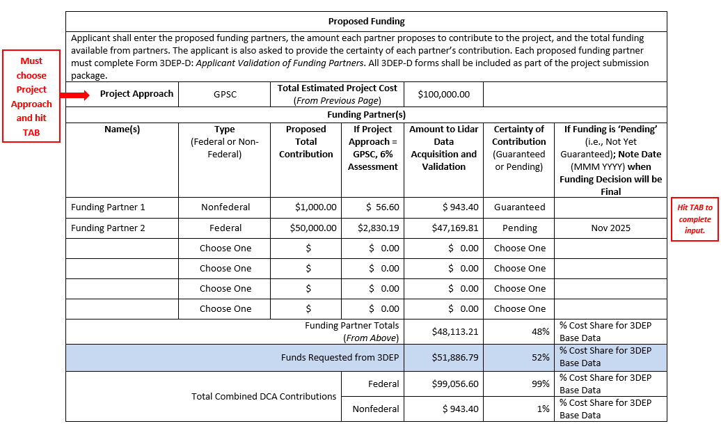
The 50% USGS cost share rule applies to the actual cost of the mapping project – not including the 6% GPSC assessment. Note that the funding table in the project summary form calculates the percent cost share for you based on the funding amounts going toward data acquisition and validation as shown in example below.
2.10 Our state agency receives a portion of our funding from a federal source. Should this funding be listed as a “federal” contribution or a “state” contribution?
3DEP and 3DHP are partnership programs that rely on the collaborative efforts of federal, state, local, Tribal, non-profit, and private stakeholders to provide funding to support the programs. The programs track the percentage of federal and non-federal contributions. For accurate reporting we encourage applicants to list the full suite of funding partners who contribute funds to a project.
Many state agencies receive a portion of their annual operating expenses from a federal source and use it as they see fit based on the authorities under which the funds were transferred to the state. An applicant must adhere to any specific instructions or conditions noted in the original agreement.
If the USGS will receive funds directly from the federal agency (via an Interagency Agreement) or will need to invoice the federal agency directly, the applicant MUST list the federal agency as a funding partner and note the contribution as “Federal” in the funding table of Form 3DEP-A or Form 3DHP-A.
Applicants applying for Financial Assistance (Cooperative Agreements) should be as explicit as possible to support the reporting requirements of the DCA; however, the minimum requirement is to list the agencies providing funds in direct support of the project. For example, if a state Department of Natural Resources (DNR) is providing \$100,000 to support a project, the project submission can list the state DNR as the funding partner regardless of whether the state DNR received any portion of their funding from a federal source. The programs encourage applicants to note any collaboration with federal partners in their project summaries.
2.11 Do contributions from partner federal agencies (like USFS) count towards the applicant's cost share?
Federal funding that comes from state or regional federal agency offices should be included in the DCA application and should be counted towards the applicant’s cost share. Generally federal funding that comes from a federal headquarters organization will be counted towards the 3DEP or 3DHP cost share.
2.12 Is there an upper limit (dollar amount) for DCA projects?
The USGS does NOT set either a minimum or a maximum dollar amount for DCA projects. Because each project is a different size, both the partner contribution and the 3DEP or 3DHP contribution are project dependent. The common factor between all projects is the percentage of the project funding provided by the partner. The USGS has a limited amount of funding to support DCA projects. 3DEP and 3DHP reserve the right to negotiate with the applicant if a project submission is worthy but exceeds the available funding. In several cases USGS and the partner have agreed to a smaller project to reflect available funding.
2.13 We have applied for a state grant to cover a portion of our state cost share. Notification on this grant will not occur until December. Can we still submit a DCA project?
The deadline for DCA submissions is generally in the Fall (check the DCA Portal for this year's exact due dates). Project submissions received by the due date will receive priority consideration for funding. DCA project submissions will be considered for review until no remaining FY26 funds are available for obligation.
To meet the submission deadline, we suggest you submit the project and note the contribution as "Pending" (see example below) and provide the date when a decision on the funding will occur. The USGS reserves the right to hold the submission until such time as the certainty of the funding has been determined.

2.14 For funding contributions, when would we have to have the money available?
Funding timelines depend on the date of acquisition. We ask that partners have their funding agreements in place 60 days in advance of acquisition and no later than mid-July of the coming calendar year (actual date TBD). The USGS could hold project submissions with a large percentage of pending funding until more certainty is provided around the available funding.
2.15 For 3DEP data acquisition windows in spring, getting the funding agreement in order 60 days in advance of acquisition may limit collection opportunities for spring leaf-off. Would allowances or exceptions be made in this case?
3DEP will prioritize projects that indicate a spring collection and will do everything we can meet the desired collection season. It is dependent on when spring occurs in your state and how quickly agreements can be put in place.
2.16 Some of my funding may be from a non-profit foundation. Can the USGS implement an agreement directly with that funding entity as part of the funding for a DCA project?
Yes, funding agreements with private and non-profit institutions are done through a Collaborative Agreement (CA) or, less commonly, a Technical Assistance Agreement (TAA).
2.17 When you refer to “cost share", does that mean the state contribution part?
“Cost Share” reflects the partner (applicant) funding. Applicants can be federal agencies, states, localities, Tribal Nations, non-profits, or private industry. If you are a state agency applying for DCA funding, then your state funds would be the state “cost share”. The funding package for each DCA Partnership Project consists of the “partner funding” and the “funds requested from either 3DEP or 3DHP”. The funding partner(s) and their proposed contribution are listed in the “Proposed Funding Table” in the Project Summary Form (Form 3DEP-A or Form 3DHP-A).
IMPORTANT NOTE: Federal agencies, tribes, and the private sector are not eligible to apply for or receive a cooperative agreement, but they may participate as a funding partner in cooperative agreement submissions.
2.18 What are the agreements called between the USGS and local and federal partners for a GPSC contract?
For those choosing to use the Geospatial Products and Services Contracts (GPSC), non-federal and local partners provide their portion of the project funding to the USGS through a Joint Funding Agreement (JFA). Federal funding is managed through Interagency Agreements (IA).
2.19 Will each funding partner need to sign a JFA or IA? Can we combine the funds into one partner agreement?
This can be done either way. USGS can develop separate agreements with the funding partners, or the applicant can choose to collect all the funding partners’ contributions and enter into a single agreement with USGS. USGS prefers to develop agreements for funding amounts larger than about \$10K, with exceptions granted for very small projects. If your proposal includes a large number of partners or some partners contributing very small amounts, our preference is for the applicant to collect the funding and then enter into an agreement with USGS to reduce the total number of agreements and/or avoid agreements for <\$10K.
2.20 What does funding for 3DEP look like now that the national baseline is nearing completion? Will funding continue for new lidar?
The goal of the 3DEP baseline is to complete data acquisition of nationwide lidar (IfSAR in Alaska) to provide the first-ever national baseline of consistent high-resolution topographic elevation data – both bare earth and 3D point clouds. The USGS is prioritizing partnerships to complete the 3DEP baseline by or during FY26, while also transitioning towards the next generation of 3DEP coverage for areas where the baseline data are 5 or more years old (8 years in Alaska, Hawaii, and U.S. territories).
2.21 Will in-kind data be accepted as a match for project submissions, and what are the requirements?
Proposed in-kind contributions will be assessed on an individual basis to determine how well the proposed resource enables or benefits a project and whether the contribution represents a good value to the government. There are two primary forms of in-kind contribution commonly offered in DCA project submissions: services and data.
Services like surveying or data validation will not be accepted as in-kind contributions to the DCA. As a rule, if the government would not ordinarily pay for a proposed service, the service won’t be accepted as an in-kind contribution.
Data that is not already in or expected to be in the public domain may be considered for in-kind, within limits. Care must be taken when offering data collected under a grant from another federal agency where the terms of the grant include a requirement to put the data in the public domain. These types of data may be considered for an in-kind contribution if the grant data collection is scheduled to occur during or very close to the same year as the proposed DCA data collection. Data that should be in the public domain should not be held back to use as in-kind contributions to future planned DCA applications.
It is important to note that project submissions are expected to include new data acquisition in addition to any offered in-kind data.
In short, organizations should carefully consider the value of the prospective in-kind contribution to the project and specifically outline how the contribution will benefit the project in the DCA project submission. Questions about the applicability of a specific in-kind contribution can be sent to 3dep_dca@usgs.gov or 3dhp_dca@usgs.gov for review and discussion.
2.22 How is the amount available for data acquisition calculated in the proposed funding table when accounting for the GPSC assessment?
The amount available for data acquisition is calculated using a reverse percentage method. This determines the funding amount available for data acquisition before the GPSC assessment is applied. This approach is necessary when the total partner contribution includes both the data acquisition cost and the GPSC assessment.
For example, a funding partner has \$1,000 available to contribute to the project, and the GPSC assessment rate is 6%. The \$1,000 must cover both data acquisition and the assessment.
- Start with 100% - representing the pre-assessment data acquisition amount.
- Add the assessment:
100% + 6% = 106%
This means the \$1,000 represents 106% of the pre-assessment data acquisition amount. - Convert the percentage to a decimal:
106% = 1.06 - Divide the total contribution by 1.06:
\$1,000 ÷ 1.06 = \$943.40
Result: \$943.40 is available for data acquisition and \$56.60 accounts for the GPSC assessment for a total of \$1000
This method ensures accurate allocation of the cost of the project and the GPSC assessment.
Note:
This calculation does not need to be done manually. The proposed funding table in the DCA Project Summary Form automatically applies the reverse percentage method to determine the amount available for data acquisition after accounting for the GPSC assessment. However, understanding the calculation may help clarify how total contributions are allocated.
3.0 Geographic Areas of Interest (AOI) and Project Information
3.01 Are you required to submit your project on the U.S. Mapping Coordination site?
No. 3DEP, 3DHP, and the Integrated Working Group on Ocean and Coastal Mapping (IWG-OCM) have established a system to share information about areas of interest and proposed and planned elevation projects. The NOAA-sponsored U.S. Mapping Coordination, A Collaboration Site for Mapping Data Acquisition provides a comprehensive look at federal requirements and offers an opportunity for you to identify potential funding partners. The tool is useful for DCA project formulation; however, there is no requirement for an applicant to enter their project on the U.S. Mapping Coordination site, nor is registration on the U.S. Mapping Coordination site used as part of the DCA evaluation process.
3.02 Areas shown on the U.S. Mapping Coordination site cross our proposed AOI - can those entities be brought in as partners?
We encourage applicants to reach out to all Points of Contact (POCs) listed for Areas of Interest (AOIs) that intersect their proposed project area to develop funding packages. If a POC isn’t listed for an AOI, contact 3dep_dca@usgs.gov or 3dhp_dca@usgs.gov. The USGS, working with the 3DNTM Working Groups member agency POCs and the network of USGS National Map Liaisons, will help connect you with federal and non-federal partners.
3.03 How can I engage with federal agencies that do not have any priority areas on the U.S. Mapping Coordination site?
If you do not see a particular agency on the U.S. Mapping Coordination site but would like to potentially collaborate with them, please reach out to the 3DEP or 3DHP teams: 3DEP_DCA@usgs.gov or 3DHP_DCA@usgs.gov. We can provide you with contact information for the federal agency representative to the respective 3DNTM Working Group (WG). These representatives work at the national level; if they are unable to provide direct assistance, they may direct you to the appropriate regional POC. You can also reach out to your National Map Liaison to find regional or local federal agency POCs.
3.04 Should large lakes be removed from 3DEP project boundaries?
Large bodies of water can be removed from your defined project area (DPA), but the collection area must fully capture both the waterbody shoreline and any islands of a size required to meet hydroflattening requirements defined in the Lidar Base Specification. Please describe the omission from the DPA in the “Additional Project Details or Clarifications” section of the DCA Form 3DEP-A. USGS may request negotiations to evaluate removal of the waterbody if necessary.
3.05 Am I required to buffer my project boundary?
For 3DEP, The Defined Project Area (DPA) must be the Area of Interest (AOI) plus a 100-meter buffer. In addition, all tile indices must be clipped to the DPA.
Instructions for how to buffer your 3DEP project boundary are included with the DCA release materials in Form 3DEP-B: Instructions for Creating 3DEP Defined Project Area and Tile Delivery Scheme.
For 3DHP, The Defined Project Area (DPA) must be comprised of whole 10-digit or larger hydrologic units (HU) from a current version of the Watershed Boundary Dataset (WBD) with no buffer applied. Instructions for creating a 3DHP DPA are included with the DCA release materials in Form 3DEP-B: Instructions for Creating 3DHP Project Boundaries.
3.06 Am I required to use a specific tiling scheme or coordinate reference system?
3DEP DCA project deliverables will be delivered in the coordinate reference system(s) (CRS) and tiling scheme of the applicant’s choosing. The chosen CRS must have a registered EPSG code and the tiling scheme of choice must conform to the 3DEP Lidar Base Specification. Where a project area covers multiple CRS zones, USGS requires that projects be split into subareas appropriate for each zone as outlined in the “coordinate reference system” section of the current 3DEP Lidar Base Specification. A second delivery can be specified if the partner prefers a copy of the data in a single CRS in such cases. If the applicant does not have a preferred tiling scheme, the 3DEP National Indexing Scheme is available for use. The 3DEP National Indexing Scheme is designed to be used with Albers Equal Area CRS (EPSG 6350). It is available as a map service for visualization.
The Watershed Boundary Dataset (WBD) serves as the tiling scheme for 3DHP. Project area boundaries must be extracted from WBD data downloaded from the Access National Hydrography Products page. 3DHP data collected for the conterminous United States must be produced in the Albers NAD83(2011) (EPSG 6350) coordinate reference system (CRS) to maintain national consistency. The vertical CRS will be NAVD88 (EPSG 5703). The required CRS for Alaska, Hawaii, and territories are available from the USGS Elevation Derived Hydrography Acquisition specification.
3.07 Can I clip my 3DHP project boundary to a political or administrative boundary?
No. Project boundaries that include partial hydrologic units such as those clipped by a political boundary will not be accepted except where HU cross over the international boundary with Canada or Mexico or to remove areas of open water area where a HU extends into ocean to the NOAA 3 Nautical Mile Line or in bays, estuaries, and sounds.
3.08 How will HUs that extend into Canada be handled through the DCA and cost estimate? Will the area within Canada be excluded from data development?
Previously, the USGS has coordinated with both Canada and Mexico to incorporate their data into the NHD. For 3DHP we are continuing to work on coordinating with these international entities. In the meantime, for areas on the international border we will connect the previously harmonized data to the new elevation-derived hydrography. For project planning estimates we will clip the HU at the border with the understanding there will be a small cost to connect to the existing international data.
3.09 For areas of the country identified as In-Progress or Existing Lidar Data, what is the best way to identify the 3DEP QL of the lidar point cloud?
All 3DEP data is included in the United States Interagency Elevation Inventory (USIEI) and the quality level is included as illustrated below. The quality level of the data is also available through the USGS Lidar Explorer.

3.10 When identifying priority areas, what is the best online resource to identify the age of existing 3DEP data in the subject area?
Map 3DEP-G FY26 Consolidated Federal Priority Acquisition Areas shows existing 3DEP data that are 5 or more years old. The United States Elevation Inventory (USIEI) is also a good resource.
3.11 Is there a size limitation for project areas?
For 3DEP, the minimum preferred project size is 1,500 square miles. Smaller projects are considered on a case-by-case basis:
- To fill in gaps in coverage.
- Where the project AOI defines a complete geophysical (such as a watershed) or political (such as a county) unit.
- For projects that represent significant cost share by the applicant.
- When the proposed acquisition covers an area where significant changes to the landscape have occurred.
For 3DHP, DPA comprised of full 8-digit HU are preferred but combinations of 8- and 10-digit HU will be considered, particularly where full 8-digit HU cross political boundaries such as state or county lines. Projects entirely based on or including one or more stand-alone 12-digit HU will not be accepted except where required to fill data gaps or with express permission from the USGS Hydrography Data Acquisition Lead by emailing 3dhp_dca@usgs.gov.
Applicants interested in very small project areas are encouraged to use the U.S. Mapping Coordination site to find partners and expand that area into a larger project.
3.12 How do we create a 3DHP project when a watershed boundary extends beyond our state boundary? The neighboring state does not have 3DEP data along our border.
Projects must be mapped within full hydrologic units defined by the Watershed Boundary Dataset (WBD) for consistency. Smaller hydrologic units entirely within the state boundary could be selected for the project. The remaining area would have to wait until 3DEP data is available.
3.13 Where/how can 3DHP data and status information be accessed?
The first version of 3DHP has been published and is comprised mostly of legacy NHD data. As new hydrography derived from 3DEP comes through the DCA and is accepted, it will replace existing NHD data. Spatial metadata is being designed to identify hydrologic units with updated hydrography. Status maps of available and in progress 3DHP are available on the 3DHP website.
3.14 Are samples of final 3DHP project data available to improve understanding of how this data may be used at the local level?
Final 3DHP project data for 8-digit hydrologic unit 02050302 (Lower Juniata) and 10-digit hydrologic unit 0601010403 (Holston River) have been published and are available through The National Map 3DHP Feature Service. Additional project areas, including in Alaska, are in the publishing queue and will be available through the rest services as soon as they are ingested into the national database.
3.15 In the August webinar it was noted that 3DHP won’t be focused in areas with ongoing work. What is the spatial extent for determining that?
A shapefile of available or in-progress EDH for 3DHP is available as part of the 3DHP DCA application materials linked on the DCA Portal. The shapefile can be accessed from the link to Map 3DHP-F - 3DHP Status.
3.16 What is the anticipated turnaround time for a 3DHP project?
The timeframe for data to go from collection through validation is currently estimated at approximately 1.5 years, dependent upon project size and complexity of terrain.
3.17 For 3DHP, does the lidar data need to be collected in the same year as contract award or can historical data within the last year be used if it meets the specification?
There is no requirement regarding the vintage of the lidar collection but Elevation-derived hydrography (EDH) for 3DHP must be produced from existing, published 3DEP data.
3.18 What source lidar can be used for 3DHP?
Only lidar data that has not been validated and published by 3DEP as meeting the Lidar Base Specification (LBS) or meeting the LBS with an accepted variance may not be used for 3DHP DCA projects.
4.0 Technical, Base Specifications, Products and Services, Non-Conventional Technologies
4.01 Are lidar-derived products like bare-earth model covered by DCA?
The DCA covers the acquisition, data validation and delivery of all products as defined in the “Deliverables” section of the Lidar Base Specification. A bare-earth DEM is included as a standard deliverable. For applicants selecting to make use of the USGS Geospatial Products and Services Contracts (GPSC), additional products and services are available; however, the full cost of the upgrades are the responsibility of the applicant.
4.02 Can you explain the conditions under which Geiger Mode and Single Photon Lidar would be considered?
Data collected using Geiger Mode and Single Photon lidar systems do not currently meet the 3DEP Lidar Base Specification, which was written to specifically address conventional lidar systems. Applications for the use of non-conventional technologies will be considered and reviewed against the project evaluation considerations, with noted exceptions to the lidar base specifications. All exceptions to the lidar base specifications and other data anomalies resulting from the use of non-conventional lidar systems will be discussed, documented, and agreed upon prior to GPSC task order or cooperative agreement award.
4.03 Our area of interest intersects with an area of culturally sensitive archeological artifacts that we do not wish to be published. Can the USGS restrict the public distribution of data over these areas?
The DOI Policy on Consultation with Indian Tribes and the DOI Policy on Consultation with Alaska Native Claims Settlement Act (ANCSA) Corporations requires that DOI Agencies provide federally-recognized Indian Tribes or ANCSA Corporations the opportunity to consult with the Agency before taking any action affecting Tribal or ANCSA Corporation interests.
USGS has determined that the acquisition and publication of airborne lidar for Tribal lands requires Tribal notification. All DCA projects, regardless of funding instrument used, are subject to this policy. 3DHP data will be derived from previously available, lower resolution 1/3 arc-second 3DEP elevation data or from data already present in the National Hydrography Dataset over areas where Tribes have objected to public release of high resolution 3DEP lidar data products for their lands.
The USGS sent a national notification letter to federally recognized Indian Tribes, ANSCA Corporations, and Native Hawaiian Organizations about ongoing data acquisition for both 3DEP and 3DHP. If the Tribe objects to public release of the products resulting from the lidar acquisition for their lands, the data may not be published. All other project area data outside of the Tribal land boundaries will be published. All non-federal entities must receive written permission from the Tribe to receive a copy of the restricted data regardless of their status as a funding partner. Entities who receive a copy may not further distribute the restricted Tribal data.
4.04 Are tribal lands the only potential exception to the 3DEP acquisition and/or public distribution policy?
The Department of Defense (DOD) imposes some restrictions over military and other DOD installations. Any known restrictions in your proposed area of interest (AOI) will be identified and discussed with the applicant prior to award. Other concerns or questions about restricted areas within your AOI should be listed in Form 3DEP-A or Form 3DHP-A under Additional Project Details or Clarifications.
If you would like more information on if a specific area has restrictions due to tribal/military/other, please email 3DEP_dca@usgs.gov.
4.05 Does USGS have a definition of Tribal lands? Does this include fee title lands as well as trust lands?
Per the DOI Tribal Consultation Policy, the USGS notifies and offers consultation based on federally recognized reservations and trust lands. The USGS does not notify on fee title or fee simple land. For the DCA Tribal notification and consultation process, the USGS determines the location and extent of federally recognized Tribal trust lands using the combined data of the Census TIGER American Indian Areas Related National Geodatabase and the Bureau of Indian Affairs American Indian and Alaskan Native Land Area Representations.
►Please note that the Census layer also includes state recognized Tribal lands, but we do not offer consultation to those Tribes per the DOI Tribal Consultation policy.
USGS Definition of Tribal Lands: Tribal trust lands are lands held in trust by the U.S. Government (the trustee) on behalf of a federally recognized Indian tribe. These lands are subject to federal oversight for sale or leasing. Tribal trust lands are predominantly, though not solely, termed reservations but may also be called pueblos or rancherias, based on the unique history of each tribe. In some cases, a tribe may have trust lands that are located outside the exterior boundaries of its reservation, pueblo, or rancheria. A tribe may also own land in fee simple where it does not have the same jurisdictional power that it does on its tribal trust lands, nor does the sale or alienation of these fee lands necessitate the federal oversight required with tribal trust lands.
4.06 Is DCA funding available for mobile terrestrial lidar or Uncrewed Aircraft System (UAS) collection efforts?
No, the goals and objectives of 3DEP are currently best served through large aerial surveys. The goal of the DCA is to help achieve the 3DEP goal of nationwide coverage of high-resolution elevation. To accomplish this goal, the USGS prefers to fund lidar surveys over a relatively large area to achieve economies of scale. Currently, the minimum preferred project size is 1,500 square miles but smaller projects are considered on a case-by-case basis:
- To fill in gaps in coverage.
- Where the project AOI defines a complete physical or political unit.
- For projects that represent significant cost share by the applicant.
- When the proposed acquisition covers an area over which significant changes to the landscape have occurred.
Although mobile terrestrial lidar and UAS have been proven to produce lidar point clouds that easily exceed the point density and accuracy requirements of 3DEP, the project footprints are so small that we would likely be required to recollect these very small areas when contracting for lidar surveys over the surrounding area.
4.07 Is 3DEP DCA funding available to support research in the use of drones to collect lidar data?
The 3DEP DCA does not provide funding for research. 3DEP recognizes the need for continued research as noted on page 25 of The 3D Elevation Program Initiative – A Call for Action, Research Requirements; however, research needs will not be addressed through the DCA.
4.08 The 3DEP DCA instructions note “exceptions for non-conventional technologies”. Would inland bathymetry sensors (a) be considered a non-conventional tech and (b) be subject to consideration by 3DEP?
The DCA funding is set aside to support partnerships for the acquisition of topographic lidar. The goal of the 3DEP is nationwide topographic lidar (IfSAR in Alaska). The DCA program funding is designated to support this goal. 3DEP recognizes the need for research in new technologies and the need to develop acquisition strategies that support a complete landscape model which may require the acquisition of both topographic and bathymetric (inland, coastal) data.
Since FY19, the USGS has provided some funding to support research projects that included the acquisition of inland bathymetry; however, those projects were not supported through DCA funding. The USGS Geospatial Products and Services Contract (GPSC) can support the acquisition of bathymetric data outside of the DCA. The team can help define project needs and can develop a project planning estimate for a project area. The USGS welcomes project submissions through the DCA that include a requirement for both topographic and bathymetric data. However, the USGS will only offer partnership dollars to support the topographic component of the acquisition. Any costs associated with the addition of bathymetric data will be borne solely by the applicant.
4.9 What is Next Generation 3DEP?
The first generation of 3DEP provides an essential national baseline of consistent, high-quality data that will continue to grow in value as it is used for comparison with new data collected over time. The 3D Nation Elevation Requirements and Benefits Study was commissioned by NOAA and USGS to understand inland, nearshore, and offshore elevation data requirements and benefits. USGS used the results of the 3D Nation Study to design the next generation program to provide increased quality levels (QLs) and refresh rates with more flexibility to meet changing user needs.
Key changes between next generation (next gen 3DEP) and baseline 3DEP is an increase in quality level from QL2 (with QL5 in Alaska) to QL1 or QL2 everywhere in the next gen 3DEP. We are also looking to shorten the update frequency from our original baseline goal, which was 8 years, to 5 years for CONUS in next gen 3DEP and 8 years in Alaska, Hawaii, and the U.S. territories.
These developments are outlined in the 3D National Topography Model Call for Action- Part 2: The Next Generation 3D Elevation Program published in FY25. In addition, the Lidar Base Specification webpage always provides the current version of the 3DEP LBS.
4.10 Do DCA GPSC and financial assistance project approaches require that data processing work be done within the United States?
The USGS requires all data processing for GPSC and financial assistance DCA projects to be performed within the United States.
4.11 Have best practices or recommended workflows for 3DHP been developed? Will more USGS guidance become available on standards such as automated processes and/or level of hydro enforcement needed to get a DEM ready to generate elevation-derived flowlines?
The USGS does not plan to develop or provide recommended workflows or guidance for generating elevation-derived flowlines. Data must meet the EDH specifications and READ rules available on the Hydrography Standards and Specifications page before it can be ingested into 3DHP.
4.12 Since lidar collections are typically not acquired by HUs, 3DHP projects may have to be done with a combo of QL1 and QL2 3DEP lidar. Is that a problem?
3DHP is standardized on a 1-meter Digital Elevation Model (DEM) produced from lidar Original Product Resolution (OPR) DEMs for CONUS and 5-meter DEMs for Alaska. It does not require a uniform quality level for the base lidar data.
4.13 Are there any anticipated updates or changes to the Lidar Base Specification (LBS) this year?
The 3DEP Lidar Base Specification undergoes a continuous revision and update process. Revision requests are submitted through the 3DEP Working Group (WG) and the National Geospatial Technical Operations Center (NGTOC). Revisions considered for the next version of the LBS and their current status can be found here: Lidar Base Specification Revision Status | U.S. Geological Survey. The Lidar Base Specification webpage always provides the current version of the 3DEP LBS.
4.14 Do the deliverables for 3DHP include a seamless DEM raster dataset? Or is having that seamless DEM a requirement prior to applying? Will costs be reduced if a seamless DEM is provided by the partner before the project starts? Or can in-kind time for development of the seamless DEM count toward the 3DHP partnership funds?
It is not a requirement to have a seamless DEM prior to applying. The seamless DEM used to produce 3DHP will either be provided by a data acquisition vendor or be based on a new seamless 1-meter product currently in work at USGS. These DEMs will be publicly available. Costs will not be reduced if a seamless DEM is provided by the partner nor will in-kind time count toward the partner’s cost share. USGS will not use seamless DEMs produced by partners for 3DHP derivation.
Related
DCA FAQ Navigate DCA
Navigate the 3DNTM DCA The 3DNTM Data Collaboration Announcement facilitates partnering with the USGS and other Federal agencies to acquire high-quality 3D elevation and hydrography data for the Nation. Follow these steps to apply. Find partnerships Engage Federal, State, Tribal, local, academic, and private partners and stakeholders in your geographic area of interest Select approach USGS manages...