Heading out to do field work for a permafrost study in the Yukon River
Heading out to do field work for a permafrost study in the Yukon RiverHeading out to do field work for a permafrost loss study in the Yukon River Basin.


Official websites use .gov
A .gov website belongs to an official government organization in the United States.

Secure .gov websites use HTTPS
A lock () or https:// means you’ve safely connected to the .gov website. Share sensitive information only on official, secure websites.

Browse images from a wide range of science topics covered by USGS.

Heading out to do field work for a permafrost loss study in the Yukon River Basin.
Heading out to do field work for a permafrost loss study in the Yukon River Basin.

Geologist and cataclastic shear zones in the Melozitna granite in the Ruby batholith. This granite contains abundant monazite and high levels of thorium and rare earth elements.
Geologist and cataclastic shear zones in the Melozitna granite in the Ruby batholith. This granite contains abundant monazite and high levels of thorium and rare earth elements.

Enlarged details of Survey Area 1 showing new multibeam bathymetry data (rainbow colors) acquired on R/V Solstice near Cross Sound and Glacier Bay National Park, southeastern Alaska. Arrows highlight the surface expression, or trace, of the Queen Charlotte-Fairweather fault.
Enlarged details of Survey Area 1 showing new multibeam bathymetry data (rainbow colors) acquired on R/V Solstice near Cross Sound and Glacier Bay National Park, southeastern Alaska. Arrows highlight the surface expression, or trace, of the Queen Charlotte-Fairweather fault.

Profile of newly discovered volcano-like cone in sonar record collected off southern Alaska. The cone’s summit is at about 1,000 meters water depth. Note fluid plume (blue) rising more than 700 meters upward from the summit.
Profile of newly discovered volcano-like cone in sonar record collected off southern Alaska. The cone’s summit is at about 1,000 meters water depth. Note fluid plume (blue) rising more than 700 meters upward from the summit.

Emperor geese at the shoreline in Kodiak.
Emperor geese at the shoreline in Kodiak.

Scanning Electron Microscope image of resuspended volcanic ash from the 1912 Novarupta-Katmai deposits in the Katmai region, picked up during high winds on November 1, 2015 and carried to Larsen Bay on Kodiak Island, AK. Sample collected by Sherry Harmes of Larsen Bay.
Scanning Electron Microscope image of resuspended volcanic ash from the 1912 Novarupta-Katmai deposits in the Katmai region, picked up during high winds on November 1, 2015 and carried to Larsen Bay on Kodiak Island, AK. Sample collected by Sherry Harmes of Larsen Bay.
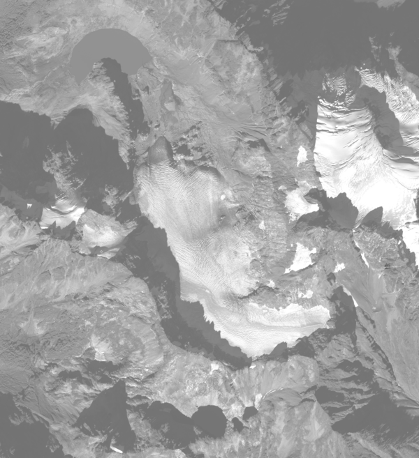
Aerial photograph of South Cascade Glacier, WA taken October 14th, 2015.
Aerial photograph of South Cascade Glacier, WA taken October 14th, 2015.

A Red-breasted Nuthatch captured at an Anchorage banding station
A Red-breasted Nuthatch captured at an Anchorage banding station

Female and cub polar bear on land near Kaktovik, Alaska
Female and cub polar bear on land near Kaktovik, Alaska

USGS\AVO seismologist works to replace an old seismometer at seismic station LSSA on Little Sitkin Volcano in the western Aleutian Arc.
USGS\AVO seismologist works to replace an old seismometer at seismic station LSSA on Little Sitkin Volcano in the western Aleutian Arc.

AVO seismologists work to repair a seismic station on Little Sitkin Volcano in the western Aleutians Islands.
AVO seismologists work to repair a seismic station on Little Sitkin Volcano in the western Aleutians Islands.

Earth MRI - Yukon Tanana Uplands Alaska

Helicopter landing to pick up field personnel after a day of geologic mapping and sampling in the Fortymile region north of Tok, Alaska.
Helicopter landing to pick up field personnel after a day of geologic mapping and sampling in the Fortymile region north of Tok, Alaska.

A high alpine tributary of the Agashashok River.
A high alpine tributary of the Agashashok River.

Allen Bondurant measuring the depth to permafrost along a thermokarst lake shore.
Allen Bondurant measuring the depth to permafrost along a thermokarst lake shore.

A mother caribou and her offspring, east of Chicken, Alaska (on the Yukon-Alaska border).
A mother caribou and her offspring, east of Chicken, Alaska (on the Yukon-Alaska border).

USGS scientist examining outcrops of strongly deformed and metamorphosed rock along Divide Mountain in the Yukon-Tanana upland of eastern Alaska
USGS scientist examining outcrops of strongly deformed and metamorphosed rock along Divide Mountain in the Yukon-Tanana upland of eastern Alaska

Half-meter-thick quartz veins cut across outcrops of granitic gneiss on Divide Mountain along the Alaska-Yukon border, August 2015
Half-meter-thick quartz veins cut across outcrops of granitic gneiss on Divide Mountain along the Alaska-Yukon border, August 2015

Sediment core showing sandy tsunami deposits over soil from an upland environment on Sitkalidak Island, Alaska.
Sediment core showing sandy tsunami deposits over soil from an upland environment on Sitkalidak Island, Alaska.

Rob Wilson pipetting PCR products into an acrylamide gel; after electrophoresis he'll be able to visualize fragment size differences within and among individuals.
Rob Wilson pipetting PCR products into an acrylamide gel; after electrophoresis he'll be able to visualize fragment size differences within and among individuals.

Dolly Varden in a minnow trap in the Agashashok River drainage. This is part of the Hydro-Ecoloy of Arctic Thawing (HEAT) project.
Dolly Varden in a minnow trap in the Agashashok River drainage. This is part of the Hydro-Ecoloy of Arctic Thawing (HEAT) project.