
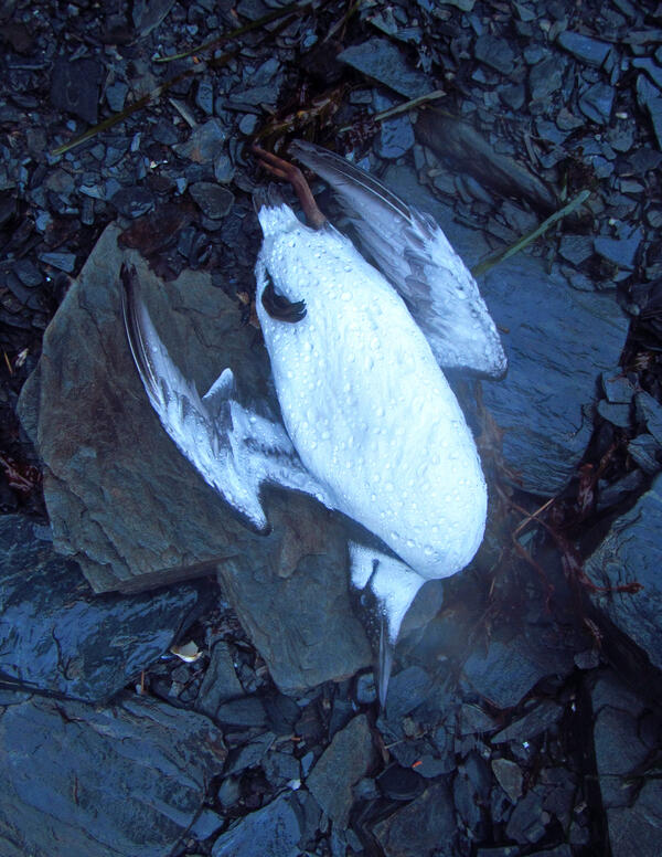
A freshly deceased Common Murre carcass recovered following the massive die-off of murres in 2015/2016. Cochrane Bay, Prince William Sound
Images
Browse images from a wide range of science topics covered by USGS.
Filter Total Items: 988

Freshly deceased Common Murre carcass
A freshly deceased Common Murre carcass recovered following the massive die-off of murres in 2015/2016. Cochrane Bay, Prince William Sound

Freshly deceased Common Murre carcass recovered
A freshly deceased Common Murre carcass recovered following the massive die-off of murres in 2015/2016. Cochrane Bay, Prince William Sound.
A freshly deceased Common Murre carcass recovered following the massive die-off of murres in 2015/2016. Cochrane Bay, Prince William Sound.

Dead Common Murres found on the beach in Cochrane Bay, Prince William
Dead Common Murres found on the beach in Cochrane Bay, Prince WilliamDead Common Murres found on the beach in Cochrane Bay, Prince William Sound on Jan 10, 2016. These birds were part of the large die-off of Common Murres across the Gulf of Alaska in 2015-2016.
A dead Common Murre found on the beach in Prince William Sound
A dead Common Murre found on the beach in Prince William SoundA dead Common Murre found on the beach in Prince William Sound on Jan 7, 2016. This bird was part of the large die-off of Common Murres across the Gulf of Alaska in 2015-2016.

Drilling into permafrost on Alaska's Arctic coast
On remote Barter Island, Alaska, Bruce Richmond (right) and Cordell Johnson drill into 500-foot-thick permafrost using a handheld drill with a 2-inch drill bit—a challenging task! It can take 3 hours to drill nearly 20 feet down.
On remote Barter Island, Alaska, Bruce Richmond (right) and Cordell Johnson drill into 500-foot-thick permafrost using a handheld drill with a 2-inch drill bit—a challenging task! It can take 3 hours to drill nearly 20 feet down.

Drilling to take water chemistry samples for permafrost study in the Y
Drilling to take water chemistry samples for permafrost study in the YDrilling to take water chemistry samples for permafrost study in the Yukon River Basin
Drilling to take water chemistry samples for permafrost study in the Y
Drilling to take water chemistry samples for permafrost study in the YDrilling to take water chemistry samples for permafrost study in the Yukon River Basin
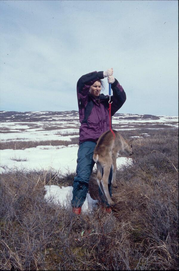
USGS biologist weighs a newborn caribou calf in Alaska
USGS biologist weighs a newborn caribou calf in AlaskaUSGS biologist Gretchen Roffler weighs a newborn caribou calf in Denali National Park, Alaska.
USGS biologist weighs a newborn caribou calf in Alaska
USGS biologist weighs a newborn caribou calf in AlaskaUSGS biologist Gretchen Roffler weighs a newborn caribou calf in Denali National Park, Alaska.

Yakobi Sea Valley
Enlarged map of the Yakobi Sea Valley. Closeup view (upper right) shows right-lateral offset of the Yakobi Sea Valley wall by the Queen Charlotte-Fairweather fault. MCS, multichannel seismic; km, kilometers. For location, see the southeastern Alaska trackline map.
Enlarged map of the Yakobi Sea Valley. Closeup view (upper right) shows right-lateral offset of the Yakobi Sea Valley wall by the Queen Charlotte-Fairweather fault. MCS, multichannel seismic; km, kilometers. For location, see the southeastern Alaska trackline map.

Collecting permafrost information on the Tahana River
Collecting permafrost information on the Tahana RiverDavid Pelunis-Messier and Milton Roberts navigating on the Tanana River, a main tributary of the Yukon River. The two are taking part in the Yukon River permafrost study.
Collecting permafrost information on the Tahana River
Collecting permafrost information on the Tahana RiverDavid Pelunis-Messier and Milton Roberts navigating on the Tanana River, a main tributary of the Yukon River. The two are taking part in the Yukon River permafrost study.

Study region along the Queen Charlotte-Fairweather fault
Study region along the Queen Charlotte-Fairweather faultStudy region along the Queen Charlotte-Fairweather fault offshore southeastern Alaska. Rectangles show locations of the two USGS-led marine geophysical surveys in May and August 2015. The third cruise was offshore Haida Gwaii, British Columbia, and southern Alaska in September 2015.

Yakobi Sea Valley
Enlarged from previous figure, this map shows a string of basins along the fault and offset of the south wall of the Yakobi Sea Valley. Line A–B marks the location of multichannel seismic-reflection profile.
Enlarged from previous figure, this map shows a string of basins along the fault and offset of the south wall of the Yakobi Sea Valley. Line A–B marks the location of multichannel seismic-reflection profile.

Researcher takes winter water chemistry samples on the Yukon River
Researcher takes winter water chemistry samples on the Yukon RiverResearcher Carol Hasburgh taking winter water chemistry samples on the Yukon River for a permafrost loss study.
Researcher takes winter water chemistry samples on the Yukon River
Researcher takes winter water chemistry samples on the Yukon RiverResearcher Carol Hasburgh taking winter water chemistry samples on the Yukon River for a permafrost loss study.

USGS scientist places radiocollar on a sedated bull caribou in Alaska
USGS scientist places radiocollar on a sedated bull caribou in AlaskaUSGS scientist Layne Adams places a radiocollar on a sedated large bull caribou in Denali National Park, Alaska.
USGS scientist places radiocollar on a sedated bull caribou in Alaska
USGS scientist places radiocollar on a sedated bull caribou in AlaskaUSGS scientist Layne Adams places a radiocollar on a sedated large bull caribou in Denali National Park, Alaska.

Calyptogena spp. in Alaska
These clams (Calyptogena spp.) were discovered in about 1000 meter-deep waters off the southern tip of Alaska near a 250-meter-high cone rising from the seafloor and 10 kilometers from the Queen Charlotte-Fairweather fault.
These clams (Calyptogena spp.) were discovered in about 1000 meter-deep waters off the southern tip of Alaska near a 250-meter-high cone rising from the seafloor and 10 kilometers from the Queen Charlotte-Fairweather fault.

Seafloor trace of the Queen Charlotte-Fairweather fault
Seafloor trace of the Queen Charlotte-Fairweather faultSeafloor trace of the Queen Charlotte-Fairweather fault (from top left to bottom right) offsets the edge of the Yakobi Sea Valley off southeast Alaska. This 700-mile-long fault has generated large earthquakes in the past. Future shocks—and tsunamis—could threaten coastal communities in the U.S. and Canada. (Color-coded depths, in meters, were mapped in 2015.)

Permafrost Loss Dramatically Changes Yukon River Chemistry and Hydrolo
Permafrost Loss Dramatically Changes Yukon River Chemistry and HydroloYukon River freezing up at Pilot Station, AK
Permafrost Loss Dramatically Changes Yukon River Chemistry and Hydrolo
Permafrost Loss Dramatically Changes Yukon River Chemistry and HydroloYukon River freezing up at Pilot Station, AK

Whitefish drying on a fish rack in Pilot Station, AK
Whitefish drying on a fish rack in Pilot Station, AKWhitefish drying on a fish rack in Pilot Station, AK, in the Yukon River Basin.
Whitefish drying on a fish rack in Pilot Station, AK
Whitefish drying on a fish rack in Pilot Station, AKWhitefish drying on a fish rack in Pilot Station, AK, in the Yukon River Basin.

Heading out to do field work for a permafrost study in the Yukon River
Heading out to do field work for a permafrost study in the Yukon RiverHeading out to do field work for a permafrost loss study in the Yukon River Basin.
Heading out to do field work for a permafrost study in the Yukon River
Heading out to do field work for a permafrost study in the Yukon RiverHeading out to do field work for a permafrost loss study in the Yukon River Basin.

Shearing of the Melozitna Granite
Geologist and cataclastic shear zones in the Melozitna granite in the Ruby batholith. This granite contains abundant monazite and high levels of thorium and rare earth elements.
Geologist and cataclastic shear zones in the Melozitna granite in the Ruby batholith. This granite contains abundant monazite and high levels of thorium and rare earth elements.

Queen Charlotte-Fairweather fault
Enlarged details of Survey Area 1 showing new multibeam bathymetry data (rainbow colors) acquired on R/V Solstice near Cross Sound and Glacier Bay National Park, southeastern Alaska. Arrows highlight the surface expression, or trace, of the Queen Charlotte-Fairweather fault.
Enlarged details of Survey Area 1 showing new multibeam bathymetry data (rainbow colors) acquired on R/V Solstice near Cross Sound and Glacier Bay National Park, southeastern Alaska. Arrows highlight the surface expression, or trace, of the Queen Charlotte-Fairweather fault.

Sidescan sonar record off so. Alaska
Profile of newly discovered volcano-like cone in sonar record collected off southern Alaska. The cone’s summit is at about 1,000 meters water depth. Note fluid plume (blue) rising more than 700 meters upward from the summit.
Profile of newly discovered volcano-like cone in sonar record collected off southern Alaska. The cone’s summit is at about 1,000 meters water depth. Note fluid plume (blue) rising more than 700 meters upward from the summit.