
The male Common Goldeneye performs a complex courtship display during winter and early spring. These diving ducks eat mostly aquatic invertebrates and fish and females nest in tree cavities.
Images
Browse images from a wide range of science topics covered by USGS.
Filter Total Items: 988
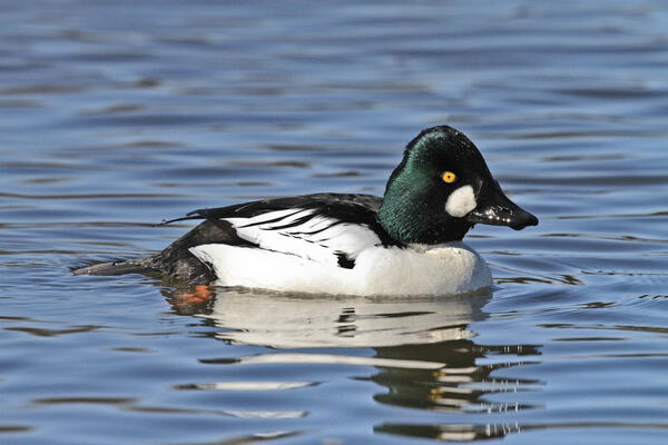
Male Common Goldeneye
The male Common Goldeneye performs a complex courtship display during winter and early spring. These diving ducks eat mostly aquatic invertebrates and fish and females nest in tree cavities.

Controlled fire studies provide data on archaeological sites impacts
Controlled fire studies provide data on archaeological sites impactsControlled experiments that simulate fire environments provide critical information for understanding how fire intensity and duration impact archaeological resources

U.S. Geological Survey offices in Glenn Olds Hall on the Alaska Pacific University
U.S. Geological Survey offices in Glenn Olds Hall on the Alaska Pacific UniversityU.S. Geological Survey offices in Glenn Olds Hall on the Alaska Pacific University. Photo taken from across University Lake.
U.S. Geological Survey offices in Glenn Olds Hall on the Alaska Pacific University
U.S. Geological Survey offices in Glenn Olds Hall on the Alaska Pacific UniversityU.S. Geological Survey offices in Glenn Olds Hall on the Alaska Pacific University. Photo taken from across University Lake.

The old Kennecott copper mill in the winter
The old Kennecott copper mill in the winter. Kennecott was once a thriving mine and mill during the early 1900s. The mines are 5 miles up the mountain.
The old Kennecott copper mill in the winter. Kennecott was once a thriving mine and mill during the early 1900s. The mines are 5 miles up the mountain.

Cackling goose (Branta hutchinsii) on the Colville River Delta
Cackling goose (Branta hutchinsii) on the Colville River DeltaCackling goose (Branta hutchinsii) on the Colville River Delta. Photo by Ryan Askren, USGS.
Cackling goose (Branta hutchinsii) on the Colville River Delta
Cackling goose (Branta hutchinsii) on the Colville River DeltaCackling goose (Branta hutchinsii) on the Colville River Delta. Photo by Ryan Askren, USGS.

Sampling for invasive northern pike in south central Alaska.
Sampling for invasive northern pike in south central Alaska.Sampling for invasive northern pike in south central Alaska.
Sampling for invasive northern pike in south central Alaska.
Sampling for invasive northern pike in south central Alaska.Sampling for invasive northern pike in south central Alaska.

Common Eider pair
A mated pair of Common Eider swim across a lake in northern Alaska.
Photography by Jeff Wasley.
A mated pair of Common Eider swim across a lake in northern Alaska.
Photography by Jeff Wasley.

Bog and boreal forest in Alaska
Stark comparison between bog (no permafrost) in the foreground and a boreal forest (with permafrost) in the background in the Alaskan interior.
Stark comparison between bog (no permafrost) in the foreground and a boreal forest (with permafrost) in the background in the Alaskan interior.

Walrus bellowing while hauled out on land in the eastern Chukchi Sea
Walrus bellowing while hauled out on land in the eastern Chukchi SeaWalrus bellowing while on shore in 2013 in the Eastern Chukchi Sea.
Walrus bellowing while hauled out on land in the eastern Chukchi Sea
Walrus bellowing while hauled out on land in the eastern Chukchi SeaWalrus bellowing while on shore in 2013 in the Eastern Chukchi Sea.

Walruses are very social
Walruses are very social animals and like to be in constant contact with other walruses. Photo taken during USGS research efforts permitted under US Fish and Wildlife Service Permit No. MA801652-3
Walruses are very social animals and like to be in constant contact with other walruses. Photo taken during USGS research efforts permitted under US Fish and Wildlife Service Permit No. MA801652-3

USGS wildlife biologist working with walruses
Walruses gathered by the tens of thousands in September 2013 to rest on the shores of the Chukchi Sea near the coastal village of Point Lay, Alaska.
Walruses gathered by the tens of thousands in September 2013 to rest on the shores of the Chukchi Sea near the coastal village of Point Lay, Alaska.

Walruses resting on shore near Point Lay, Alaska
Walruses gathered by the tens of thousands in September 2013 to rest on the shores of the Chukchi Sea near the coastal village of Point Lay, Alaska.
Walruses gathered by the tens of thousands in September 2013 to rest on the shores of the Chukchi Sea near the coastal village of Point Lay, Alaska.

An adult female walrus rests on the edge of a large haulout
An adult female walrus rests on the edge of a large hauloutWalruses gathered by the tens of thousands in September 2013 to rest on the shores of the Chukchi Sea near the coastal village of Point Lay, Alaska.
An adult female walrus rests on the edge of a large haulout
An adult female walrus rests on the edge of a large hauloutWalruses gathered by the tens of thousands in September 2013 to rest on the shores of the Chukchi Sea near the coastal village of Point Lay, Alaska.

Surprise Creek, Western North Slope of Alaska
Geologists measuring petroleum source rocks in Triassic rocks along Surprise Creek in southern part of Western North Slope.
Geologists measuring petroleum source rocks in Triassic rocks along Surprise Creek in southern part of Western North Slope.

Surprise Creek, Western North Slope of Alaska
Geologist describes petroleum source rocks in Triassic and Jurassic rocks along Surprise Creek in southern part of Western North Slope.
Geologist describes petroleum source rocks in Triassic and Jurassic rocks along Surprise Creek in southern part of Western North Slope.

Surprise Creek, Western North Slope of Alaska
Faulted and folded Triassic, Jurassic, and Cretaceous rocks along Surprise Creek in southern part of Western North Slope. The Triassic and Jurassic rocks include petroleum source rocks from which oil was generated. Geologists in orange vests for scale.
Faulted and folded Triassic, Jurassic, and Cretaceous rocks along Surprise Creek in southern part of Western North Slope. The Triassic and Jurassic rocks include petroleum source rocks from which oil was generated. Geologists in orange vests for scale.

Flooding encroaches on trees, Exit Creek
Flooding encroaches on trees, Exit Creek.
Flooding encroaches on trees, Exit Creek.

Exit Creek flooding
Exit Creek flooding across the road
Exit Creek flooding across the road

Lowe River Flood outside of Valdez, Alaska
Lowe River Flood outside of Valdez, Alaska
Lowe River Flood outside of Valdez, Alaska

Erosion along Alaska’s Arctic coastline near the village of Kaktovik
Erosion along Alaska’s Arctic coastline near the village of KaktovikNeal Pastick – lead author of the study – investigating erosion along Alaska’s Arctic coastline near the village of Kaktovik. Permafrost-dominated coasts of Alaska have drastically changed as the result of coastal transgression and storm-surge flooding which can result in the loss of cultural sites and damage to infrastructure. Photo by M.

Aerial view toward the southwest of the actively erupting cone within Veniaminof caldera
Aerial view toward the southwest of the actively erupting cone within Veniaminof calderaAerial view toward the southwest of the actively erupting cone within Veniaminof caldera. The white steam plume is produced where a lava flow is descending the side of the cone and melting snow and ice. The darker colored, ashy plume is rising in bursts from the active vent.