
Pulling in a cast net in Prince William Sound.
Images
Browse images from a wide range of science topics covered by USGS.
Filter Total Items: 988

Pulling in a cast net in Prince William Sound
Pulling in a cast net in Prince William Sound.

Scientist with a Pacific Herring caught in Prince William Sound, AK
Scientist with a Pacific Herring caught in Prince William Sound, AKSarah Schoen with a Pacific Herring in her hand that was caught in Prince William Sound, Alaska
Scientist with a Pacific Herring caught in Prince William Sound, AK
Scientist with a Pacific Herring caught in Prince William Sound, AKSarah Schoen with a Pacific Herring in her hand that was caught in Prince William Sound, Alaska

Scenic Prince William Sound, Alaska
A scenic view of the mountains and the ocean in Prince William Sound
A scenic view of the mountains and the ocean in Prince William Sound

Beautiful Prince William Sound, Alaska
A scenic view of the sea and the mountains in Prince William Sound
A scenic view of the sea and the mountains in Prince William Sound

A Wilson’s Snipe
A close up of the head of a Wilson’s Snipe.
A close up of the head of a Wilson’s Snipe.

White-fronted geese defend their nest against an arctic fox
White-fronted geese defend their nest against an arctic foxWhite-fronted geese aggressively defend their nest against an arctic fox. Arctic Coastal Plain of Alaska, USA
White-fronted geese defend their nest against an arctic fox
White-fronted geese defend their nest against an arctic foxWhite-fronted geese aggressively defend their nest against an arctic fox. Arctic Coastal Plain of Alaska, USA

Juvenile Northern Shrike
Juvenile Northern Shrike. This photo was taken on the Seward Peninsula as part of the Changing Arctic Ecosystem Boreal-Arctic Transition Zone program.
Juvenile Northern Shrike. This photo was taken on the Seward Peninsula as part of the Changing Arctic Ecosystem Boreal-Arctic Transition Zone program.

Whimbrel on the tundra on the Seward Peninsula, Alaska
Whimbrel on the tundra on the Seward Peninsula, AlaskaWhimbrel on the tundra on the Seward Peninsula, Alaska.
Whimbrel on the tundra on the Seward Peninsula, Alaska
Whimbrel on the tundra on the Seward Peninsula, AlaskaWhimbrel on the tundra on the Seward Peninsula, Alaska.

North shore of Barter Island on Alaska’s Arctic coast
North shore of Barter Island on Alaska’s Arctic coastPhoto from a time-lapse camera looking eastward along the north shore of Barter Island on Alaska’s Arctic coast, June 15, 2014. View the complete time-lapse sequence to see how the coastal bluffs and beach changed during a single summer.

Alaskan Elders
Elders Eliza Jones and Bill Williams sharing knowledge of historic land use and place names.
Elders Eliza Jones and Bill Williams sharing knowledge of historic land use and place names.

Alaska Native Youth
Alaska Native youths at the mouth of the Kodeelno' KodeelKKaakk'et (Kateel River).
Alaska Native youths at the mouth of the Kodeelno' KodeelKKaakk'et (Kateel River).

Acoustic recording device on the Seward Peninsula tundra, Alaska
Acoustic recording device on the Seward Peninsula tundra, AlaskaAn acoustic recording device on the tundra of the Seward Peninsula, Alaska
Acoustic recording device on the Seward Peninsula tundra, Alaska
Acoustic recording device on the Seward Peninsula tundra, AlaskaAn acoustic recording device on the tundra of the Seward Peninsula, Alaska

Skyler Vold conducts a bird survey on the Seward Peninsula
Skyler Vold conducts a bird survey on the Seward PeninsulaUSGS biologist Skyler Vold conducts a bird survey on Alaska’s Seward Peninsula
Skyler Vold conducts a bird survey on the Seward Peninsula
Skyler Vold conducts a bird survey on the Seward PeninsulaUSGS biologist Skyler Vold conducts a bird survey on Alaska’s Seward Peninsula

Water quality measurements on the Pilgrim River
Collecting water quality data on the Pilgrim River. Types of measurements taken were on water temperature, dissolved oxygen, pH, and conductivity.
Collecting water quality data on the Pilgrim River. Types of measurements taken were on water temperature, dissolved oxygen, pH, and conductivity.

Alaska Hyperspectral Minerals Map
Preliminary map of selected minerals for a portion of the Nabesna area of interest, near Orange Hill and Bond Creek deposits in Alaska. The image, derived from HyMap imaging spectrometer data collected in July 2014, is draped on shaded relief.
Preliminary map of selected minerals for a portion of the Nabesna area of interest, near Orange Hill and Bond Creek deposits in Alaska. The image, derived from HyMap imaging spectrometer data collected in July 2014, is draped on shaded relief.

West Twin Creek catchment with Table Top Mountain
The open black spruce forest of the West Twin Creek catchment with Table Top Mountain in the background
The open black spruce forest of the West Twin Creek catchment with Table Top Mountain in the background

Carson Baughman conducting lake survey, Kenai National Wildlife Refuge
Carson Baughman conducting lake survey, Kenai National Wildlife RefugeCarson Baughman conducting lake surveys in the Kenai National Wildlife Refuge in 2014.
Carson Baughman conducting lake survey, Kenai National Wildlife Refuge
Carson Baughman conducting lake survey, Kenai National Wildlife RefugeCarson Baughman conducting lake surveys in the Kenai National Wildlife Refuge in 2014.

Nenana River pier and sonar near Windy
Nenana River pier near Windy

Aerial image of Taku Glacier, Alaska 1948
Aerial image of Taku Glacier in 1948. The Norris Glacier can be seen on the lower left hand corner and the Hole-in-the-Wall Glacier in the upper center portion of the image. Citation: McNeil, C. J., and Baker, E. H., 2019, Geodetic data for Juneau Icefield Glaciers: orthophotos, digital elevation models, and glacier boundaries (ver 1.0, August, 2019): U.S.
Aerial image of Taku Glacier in 1948. The Norris Glacier can be seen on the lower left hand corner and the Hole-in-the-Wall Glacier in the upper center portion of the image. Citation: McNeil, C. J., and Baker, E. H., 2019, Geodetic data for Juneau Icefield Glaciers: orthophotos, digital elevation models, and glacier boundaries (ver 1.0, August, 2019): U.S.

Large polar bear being weighed by Anthony Pagano and Todd Atwood
Large polar bear being weighed by Anthony Pagano and Todd AtwoodLarge polar bear being weighed by Anthony Pagano and Todd Atwood
Large polar bear being weighed by Anthony Pagano and Todd Atwood
Large polar bear being weighed by Anthony Pagano and Todd AtwoodLarge polar bear being weighed by Anthony Pagano and Todd Atwood
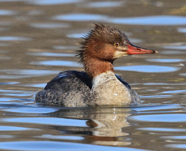
Female Common Merganser
Common Mergansers are sometimes called sawbills, fish ducks, or goosanders. The word “merganser” comes from the Latin and translates to “plunging goose”. Similar to Goldeneye ducks, mergansers usually nest in natural tree cavities.
Common Mergansers are sometimes called sawbills, fish ducks, or goosanders. The word “merganser” comes from the Latin and translates to “plunging goose”. Similar to Goldeneye ducks, mergansers usually nest in natural tree cavities.