
A view of the Sheepscot River in Maine taken by USGS hydrologic technicians while surveying the channel for the purpose of updating floodplain maps.
Images
Images below come from a wide variety of USGS science activities in the Northeast Region. Science Center staff showcase what we do, who we are, and where we work conducting science that inform decision makers and addresses societal needs.
Filter Total Items: 2050
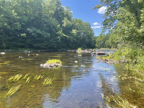
Sheepscot River in Maine
A view of the Sheepscot River in Maine taken by USGS hydrologic technicians while surveying the channel for the purpose of updating floodplain maps.

Sheepscot River in Maine
A view of the Sheepscot River in Maine taken by USGS hydrologic technicians while surveying the river. The surveyed cross-section data is used to update flood insurance rate maps for FEMA.
A view of the Sheepscot River in Maine taken by USGS hydrologic technicians while surveying the river. The surveyed cross-section data is used to update flood insurance rate maps for FEMA.
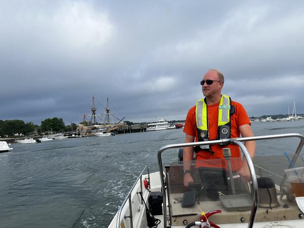
Phil Woodford (Hydro Tech) driving a boat to service a water quality buoy located in Kingston Bay, Plymouth, MA
Phil Woodford (Hydro Tech) driving a boat to service a water quality buoy located in Kingston Bay, Plymouth, MAPhil Woodford (Hydro Tech) driving a boat to service a water quality buoy located in Kingston Bay, Plymouth, MA. The Mayflower replica is in the background.
Summer 2025 Photo Contest Winner: Kaitlin Laabs, USGS at Work category

Pumping Groundwater Samples from Well at Army Base Camp Nett in Niantic, Connecticut
Pumping Groundwater Samples from Well at Army Base Camp Nett in Niantic, ConnecticutHydrologic Technician Conner Caridad observing the purge of a groundwter well located in the Army Base Camp Nett. Groundwater samples were taken and analyzed from this well for a study measuring nitrogen concentrations in groundwater before, during, and after sewering.
Adjusting Groundwater Sampler Pump in Niantic, Connecticut
Adjusting Groundwater Sampler Pump in Niantic, ConnecticutHydrologic Technician Danny Hansen adjusts the speed of peristaltic pump at a groundwater well in the Pine Grove community Grove in Niantic, CT. Groundwater samples were being taken during 2025 as a part of a broader study looking at nitrogen concentrations in groundwater before and after sewer installation.

Water Quality Sample Collection near Farm River Marina in East Haven, Connecticut
Water Quality Sample Collection near Farm River Marina in East Haven, ConnecticutA USGS hydrologic technician uses a Van Dorn sampler to collect water quality samples from the Farm River at fixed depths.
Water Quality Sample Collection near Farm River Marina in East Haven, Connecticut
Water Quality Sample Collection near Farm River Marina in East Haven, ConnecticutA USGS hydrologic technician uses a Van Dorn sampler to collect water quality samples from the Farm River at fixed depths.
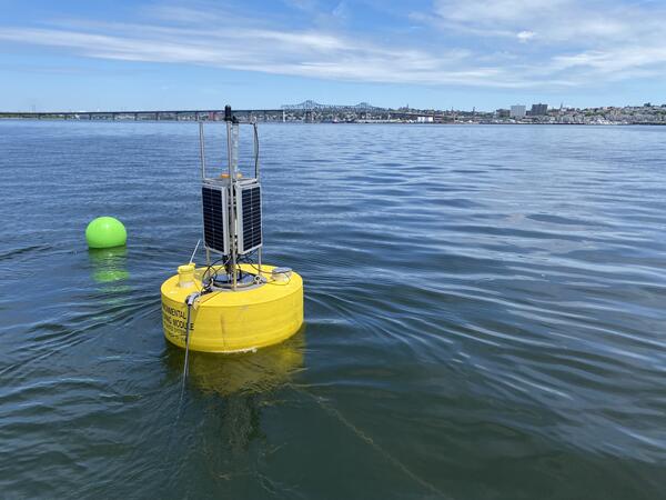
Water-Quality Buoy Deployed in Mount Hope Bay
A buoy carrying water quality monitoring equipment is deployed in Mount Hope Bay, Massachusetts, as part of a larger water-quality monitoring project.
A buoy carrying water quality monitoring equipment is deployed in Mount Hope Bay, Massachusetts, as part of a larger water-quality monitoring project.

Installing a Groundwater Well in Franklin, Massachusetts
Installing a Groundwater Well in Franklin, MassachusettsUSGS hydrologic technicians Sam Banas and Curtis Yeager install a groundwater well (MA-F2W 80) in Franklin, Massachusetts.
Installing a Groundwater Well in Franklin, Massachusetts
Installing a Groundwater Well in Franklin, MassachusettsUSGS hydrologic technicians Sam Banas and Curtis Yeager install a groundwater well (MA-F2W 80) in Franklin, Massachusetts.
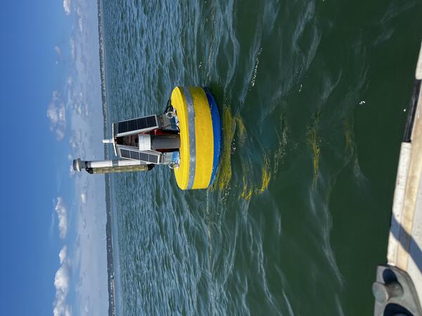
Water-Quality Monitoring Buoy in Kingston Bay, Massachusetts
Water-Quality Monitoring Buoy in Kingston Bay, MassachusettsA buoy carrying water quality monitoring equipment is deployed in Kingston Bay in South Duxbury, Massachusetts, as part of a larger water-quality monitoring project.
Water-Quality Monitoring Buoy in Kingston Bay, Massachusetts
Water-Quality Monitoring Buoy in Kingston Bay, MassachusettsA buoy carrying water quality monitoring equipment is deployed in Kingston Bay in South Duxbury, Massachusetts, as part of a larger water-quality monitoring project.
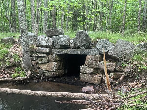
Culvert in Cromwell Brook in Acadia National Park
A culvert along Cromwell Brook under a forest road in Acadia National Park in Maine.
A culvert along Cromwell Brook under a forest road in Acadia National Park in Maine.
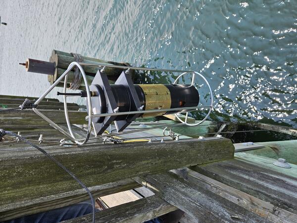
Deploying a Carbon Dioxide Sensor into Danvers River in Beverly, Massachusetts
Deploying a Carbon Dioxide Sensor into Danvers River in Beverly, MassachusettsUSGS staff deploy a carbon dioxide sensor (pCO2) from the Beverly Pier into the Danvers River in Beverly, Massachusetts. This water quality sensor deployment is a part of a larger data collection effort in several Massachusetts rivers and embayments.
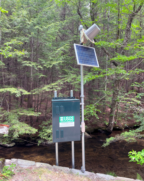
Continuous streamgage on Mill Brook at Plainfield, Massachusetts
Continuous streamgage on Mill Brook at Plainfield, MassachusettsNewly established continuous streamgage on downstream right bank at Mill Brook at Plainfield, MA - 01178230. Gage is located on River Road.
Continuous streamgage on Mill Brook at Plainfield, Massachusetts
Continuous streamgage on Mill Brook at Plainfield, MassachusettsNewly established continuous streamgage on downstream right bank at Mill Brook at Plainfield, MA - 01178230. Gage is located on River Road.

Continuous streamgage on Sudbury River at Ashland, Massachusetts
Continuous streamgage on Sudbury River at Ashland, MassachusettsRe-established continuous streamgage on downstream left bank of Sudbury River at Ashland, MA - 01097480. Gage is located on Front Street.
Continuous streamgage on Sudbury River at Ashland, Massachusetts
Continuous streamgage on Sudbury River at Ashland, MassachusettsRe-established continuous streamgage on downstream left bank of Sudbury River at Ashland, MA - 01097480. Gage is located on Front Street.
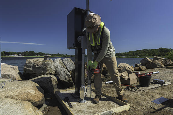
Nigel Pepin using a rotor hammer to install concrete anchors to secure a new gage to monitor the Poquonnock River
Nigel Pepin using a rotor hammer to install concrete anchors to secure a new gage to monitor the Poquonnock RiverNigel Pepin using a rotor hammer to install concrete anchors to secure a new gage to monitor the Poquonnock River in Bluff Point State Park, CT.
Summer 2025 Photo Contest Winner: Paul Solis, Honorable Mention category
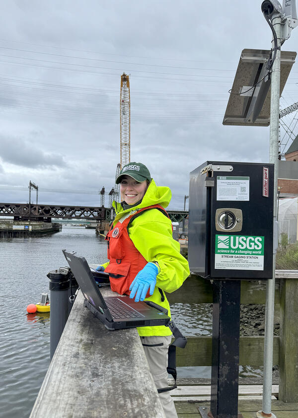
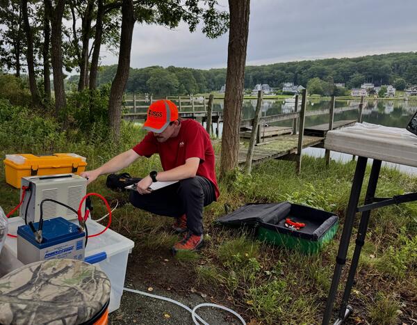
Maintaining continuous water-quality monitors
USGS Hydrologic Technician, Samantha Robinson, preforming a vertical profile and routine maintenance on continuous water quality monitors on the Norwalk River at Maritime Aquarium Near Southern Norwalk, CT (410606073245700) on May 21, 2025. Discrete water quality samples are also collected at this monitoring location.
USGS Hydrologic Technician, Samantha Robinson, preforming a vertical profile and routine maintenance on continuous water quality monitors on the Norwalk River at Maritime Aquarium Near Southern Norwalk, CT (410606073245700) on May 21, 2025. Discrete water quality samples are also collected at this monitoring location.

Continuous streamgage on Tiasquam River at West Tisbury, Massachusetts
Continuous streamgage on Tiasquam River at West Tisbury, MassachusettsNewly established continuous streamgage downstream right bank on Martha's Vineyard at Tiasquam River at West Tisbury, MA - 412238070403701. Gage is located adjacent to State Road in Chilmark, MA.

Installing New Streamgage on Martha's Vineyard
USGS staff installing a new streamgage on the island of Martha's Vineyard in Massachusetts. This streamgage is a part of the state’s cooperative hydrologic monitoring network with USGS.
USGS staff installing a new streamgage on the island of Martha's Vineyard in Massachusetts. This streamgage is a part of the state’s cooperative hydrologic monitoring network with USGS.
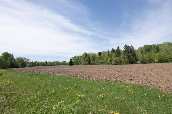
Agricultural Field in Millinocket, Maine
USGS, in cooperation with the U.S. Department of Agriculture and the University of Maine, is predicting the potential hydrological impacts based on these climatic changes using the USGS Precipitation Runoff Modeling System (PRMS) to inform the New England farming industry.
USGS, in cooperation with the U.S. Department of Agriculture and the University of Maine, is predicting the potential hydrological impacts based on these climatic changes using the USGS Precipitation Runoff Modeling System (PRMS) to inform the New England farming industry.
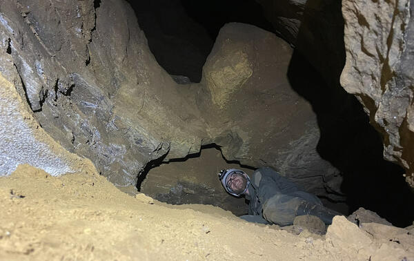
Cave sediments
U.S. Geological Survey Geologist, Alexander Gray Alex Gray examines buried sediments at Butler Cave in Virginia.
Winter 2026 Photo Contest Winner: William Odom, Honorable Mention
U.S. Geological Survey Geologist, Alexander Gray Alex Gray examines buried sediments at Butler Cave in Virginia.
Winter 2026 Photo Contest Winner: William Odom, Honorable Mention
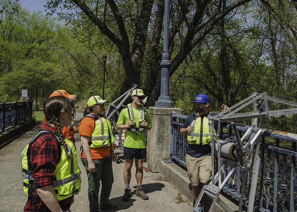
Bridge crane training
Members from the Massachusetts office of the New England Water Science Center conduct bridge crane training for water quality at Hockanum Road in East Hartford, CT, April 29, 2029.
Spring 2025 Photo Contest Winner: Paul Solis, Where We Work category
Members from the Massachusetts office of the New England Water Science Center conduct bridge crane training for water quality at Hockanum Road in East Hartford, CT, April 29, 2029.
Spring 2025 Photo Contest Winner: Paul Solis, Where We Work category

Shaun Donmoyer and Zachary Houston sampling for ALCOSAN project
Shaun Donmoyer and Zachary Houston sampling for ALCOSAN projectShaun Donmoyer and Zachary Houston sampling at the point location, three rivers, Pittsburgh PA (Jared Carte, USGS).
Shaun Donmoyer and Zachary Houston sampling for ALCOSAN project
Shaun Donmoyer and Zachary Houston sampling for ALCOSAN projectShaun Donmoyer and Zachary Houston sampling at the point location, three rivers, Pittsburgh PA (Jared Carte, USGS).