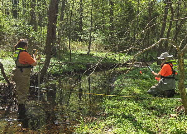
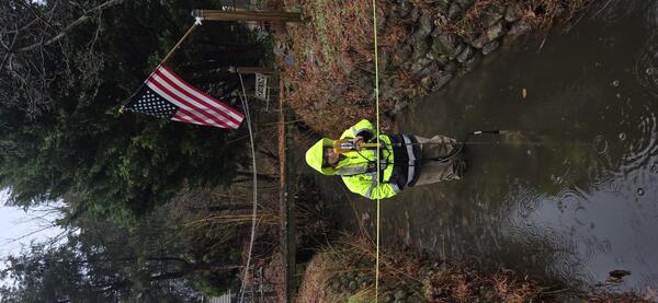
Field Work on the Allagash River near Allagash, Maine
Field Work on the Allagash River near Allagash, MaineA temporary bank-operated cableway is set up across the Allagash River in Allagash, Maine, near streamgage 01011000.
An official website of the United States government
Here's how you know
Official websites use .gov
A .gov website belongs to an official government organization in the United States.
Secure .gov websites use HTTPS
A lock () or https:// means you’ve safely connected to the .gov website. Share sensitive information only on official, secure websites.
Images below come from a wide variety of USGS science activities in the Northeast Region. Science Center staff showcase what we do, who we are, and where we work conducting science that inform decision makers and addresses societal needs.
A temporary bank-operated cableway is set up across the Allagash River in Allagash, Maine, near streamgage 01011000.
Chris Sherwood, Athina Lange, and Jin-Si Over look at a monitor hooked up to the CoastCams overlooking Marconi Beach on Cape Cod National Seashore. They are aligning the two stationary video cameras so there is a slight overlap in the look angle.
An interpretive sign put together by USGS about research on nutrient pollution entering into the coastal waters near Wickford, Rhode Island.
Pie chart showing relative amounts of copper produced by leading copper producing states in the U.S. in 2019 (derived from data in Flanagan, D.M., 2019, Copper, in Metals and minerals: U.S. Geological Survey Minerals Yearbook 2019, v. 1, p. 20.1-20.30.
A map of Connecticut showing the annual groundwater-transported nitrogen yield on the north shore of the Long Island Sound. Watersheds that have yields exceeding 500 kilograms of nitrogen per square kilometer per year are shown in yellow regardless of the magnitude of the yield.
World map of expected annual disruption of copper refinery production, in metric tons, from potential seismic activity.
Photograph taken during the 1st Annual NYWSC Dive Safety Day. The purpose of the safety day is to allow the NYWSC divers time to practice the skills they utilize during their routine dives, while also giving them a chance to work an any additional skills that might aid in dive safety and communication.
USGS geologists at a site of new sediment core in a trans-disciplinary effort to reconstruct past climate change across the country near Hannah, Wyoming, on June 26, 2024. Pictured left to right: Marci Robinson and Jean Self-Trail both Research Geologist, Northeast Region; and Marieke Dechesne, Reasearch Geologist, Rocky Mountain Region.
Andy Massey, Physical Scientist at the New England Water Science Center, surveying the tidal Boat Meadow River in Eastham, Massachusetts on June 14, 2024.
Summer 2024 Photo Contest Winner: Shannon Fisher, USGS at Work
Andy Massey, Physical Scientist at the New England Water Science Center, surveying the tidal Boat Meadow River in Eastham, Massachusetts on June 14, 2024.
Summer 2024 Photo Contest Winner: Shannon Fisher, USGS at Work
Research Hydrologist Emeritus Denis LeBlanc teaches the Gulf of Maine Council about Cape Cod hydrology in front of Ashumet Pond in Falmouth, Massachusetts.
USGS Hydrologist Paul Barlow, who served as the Chief of the Hydrologic Interpretive Branch of the New England Water Science Center, retired at the end of May 2024. Director John Bumgarner presented Paul with a plaque at his retirement gathering at the center.
Hydrologic Technician Kim Campo deploys a buoy at Fresh Pond in Cambridge, MA with sensors to monitor water temperature, wind speed/direction, and blue-green algae. Nearby continuous water quality monitoring station is 422302071083801.
Spring 2024 Photo Contest Winner: Meghan Santos, Where We Work category
Field assistant Sean Mello takes a discrete WQ measurement on the Carman’s River in Yaphank, New York, on May 22, 2024.
Summer 2024 Photo Contest Winner: Emily Krsnak, Honorable Mention
Field assistant Sean Mello takes a discrete WQ measurement on the Carman’s River in Yaphank, New York, on May 22, 2024.
Summer 2024 Photo Contest Winner: Emily Krsnak, Honorable Mention
Elizabeth Mine was a copper mine in Strafford, Vermont, that was abandoned in 1957. It was added to the U.S. Environmental Protection Agency (EPA) Superfund Program’s National Priority List in 2001. Since then, EPA and USGS have cooperated to investigate the nature and extent of contamination from weathering of waste rock rich in metals and sulfides.
Hydrologic technicians Joel Kneisley and Alexander Kind installed a streamgage and precipitation gage at Elizabeth Mine in Strafford, Vermont. This copper mine was abandoned in 1957 and added to the EPA Superfund Program’s National Priority List in 2001.
Elizabeth Mine was added to the U.S. Environmental Protection Agency (EPA) Superfund Program’s National Priority List in 2001. Since then, EPA and USGS have cooperated to investigate the nature and extent of contamination from weathering of waste rock rich in metals and sulfides.
Photograph of a salt marsh with ponding in coastal Connecticut taken during estuarine research field work.
Salt marsh with ponding in coastal Connecticut, with the sun shining brightly overhead.
Salt marsh behind impoundment in coastal Connecticut, taken during estuarine research field work.