
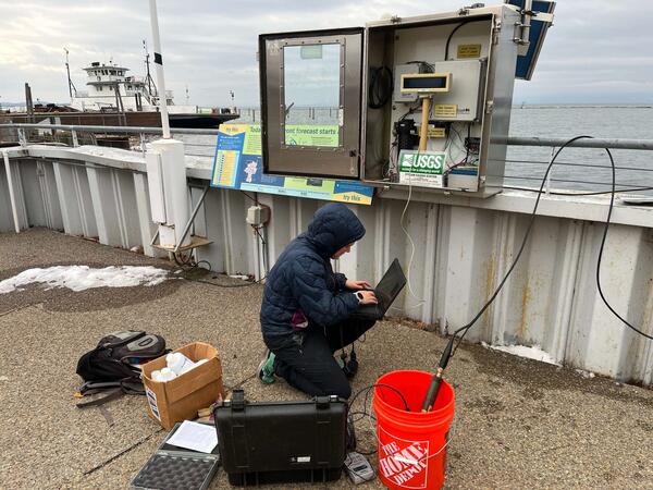
USGS Scientist makes a gage inspection during the rain event at Nepaug River near Nepaug, Connecticut - 01187800. The 1800 cubic feet per second (CFS) measured during the powerful rainstorm was the highest measurement on record to date, according to provisional data.
Images
Images below come from a wide variety of USGS science activities in the Northeast Region. Science Center staff showcase what we do, who we are, and where we work conducting science that inform decision makers and addresses societal needs.
Filter Total Items: 2050

Streamgage inspection during rain event
USGS Scientist makes a gage inspection during the rain event at Nepaug River near Nepaug, Connecticut - 01187800. The 1800 cubic feet per second (CFS) measured during the powerful rainstorm was the highest measurement on record to date, according to provisional data.
Lake Champlain Streamgage in Burlington, Vermont
The USGS New England Water Science Center operates a streamgage on Lake Champlain in Burlington, Vermont.
The USGS New England Water Science Center operates a streamgage on Lake Champlain in Burlington, Vermont.

Connecticut Office Break Room
The break room in the Connecticut Office has two walls of windows that bring in a lot of natural light.
The break room in the Connecticut Office has two walls of windows that bring in a lot of natural light.

New England Water Science Center Connecticut Office
New England Water Science Center Connecticut OfficeThe New England Water Science Center Connecticut Office is located on the campus of Goodwin University at 339 Main Street in East Hartford.
New England Water Science Center Connecticut Office
New England Water Science Center Connecticut OfficeThe New England Water Science Center Connecticut Office is located on the campus of Goodwin University at 339 Main Street in East Hartford.

Connecticut Office Garage
The New England Water Science Center's Connecticut office has a spacious three-door garage.
The New England Water Science Center's Connecticut office has a spacious three-door garage.

Neponset River in Canton, Massachusetts
A view of the Neponset River in Canton, Massachusetts, near a 01105554 USGS streamgage at Greenlodge Street.
A view of the Neponset River in Canton, Massachusetts, near a 01105554 USGS streamgage at Greenlodge Street.

Hydrologic Technician collecting a water quality sample at Moose River in Victory, VT
Hydrologic Technician collecting a water quality sample at Moose River in Victory, VTHydrologic Technician Brendan Crowley collecting a water quality sample at Moose River in Victory, VT (01134500). This site is sampled monthly for the Upper Connecticut River Watershed project.

Andrew Kowalczk entering the Oneida River to conduct annual servicing to an Index Velocity gage
Andrew Kowalczk entering the Oneida River to conduct annual servicing to an Index Velocity gageAndrew Kowalczk, a NYWSC scientific diver, entering the Oneida River to conduct annual servicing to an Index Velocity gage. The NYWSC divers service various gages across the state to ensure data collected is as accurate as possible for the cooperators and public.
Fall 2023 Photo Contest Winner: Zachary Heck, People category

Micah Kieffer holds a shortnose sturgeon
Fish Biologist Micah Kieffer holds a shortnose sturgeon during a public outreach event at EESC's S.O. Conte Research Lab in Turners Falls, MA.
Fish Biologist Micah Kieffer holds a shortnose sturgeon during a public outreach event at EESC's S.O. Conte Research Lab in Turners Falls, MA.

David Walters measuring surface elevation table that is used to assess changes in wetland surface (accretion and/or erosion).
David Walters measuring surface elevation table that is used to assess changes in wetland surface (accretion and/or erosion).David Walters measuring surface elevation table that is used to assess changes in wetland surface (accretion and/or erosion) at Money Stump in Blackwater National Wildlife Refuge in Cambridge, Maryland.
Winter 2024 Photo Contest: Melinda Martinez, Honorable Mention category

USGS Scientists and Survey Technicians deploying geophysical survey systems on the R/V Pelican in the Gulf of Mexico
USGS Scientists and Survey Technicians deploying geophysical survey systems on the R/V Pelican in the Gulf of MexicoUSGS Scientists and Survey Technicians from the Woods Hole Coastal and Marine Science Center (Laura Brothers, Dave Foster, Pat Berube and Chuck Worley) deploying geophysical survey systems on the R/V Pelican in the Gulf of Mexico.
Fall 2023 Photo Contest Winner: Seth Ackerman, Honorable Mention category
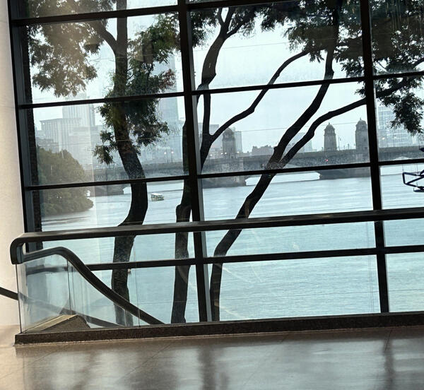
Longfellow Bridge and the Charles River, Boston, Massachusetts
Longfellow Bridge and the Charles River, Boston, MassachusettsLongfellow Bridge, completed in 1906 and renamed for Henry Wadsworth Longfellow in 1927, viewed upstream from a window inside the Museum of Science at Science Park in Boston, Massachusetts. The museum occupies the site of the 1910 Charles River Dam Bridge.
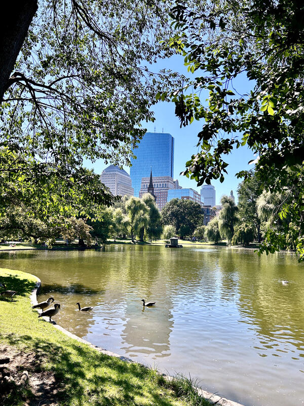
Boston Public Garden lagoon, Massachusetts — urban surface‑water feature
Boston Public Garden lagoon, Massachusetts — urban surface‑water featureThe Boston Public Garden lagoon is a shallow, human‑constructed surface‑water body situated within the historic Public Garden in downtown Boston.
Boston Public Garden lagoon, Massachusetts — urban surface‑water feature
Boston Public Garden lagoon, Massachusetts — urban surface‑water featureThe Boston Public Garden lagoon is a shallow, human‑constructed surface‑water body situated within the historic Public Garden in downtown Boston.

Screenshot of opening page for geonarrative "Hurricane Ida: U.S. Geological Survey Response in Pennsylvania to September 1-2, 2021, Flooding Related to Remnants of Hurricane Ida "
Screenshot of opening page for geonarrative "Hurricane Ida: U.S. Geological Survey Response in Pennsylvania to September 1-2, 2021, Flooding Related to Remnants of Hurricane Ida "Screenshot of title page for "Hurricane Ida: USGS Response in Pennsylvania to September 1-2, 2021, Flooding Related to Remnants of Hurricane Ida" geonarrative.
Screenshot of opening page for geonarrative "Hurricane Ida: U.S. Geological Survey Response in Pennsylvania to September 1-2, 2021, Flooding Related to Remnants of Hurricane Ida "
Screenshot of opening page for geonarrative "Hurricane Ida: U.S. Geological Survey Response in Pennsylvania to September 1-2, 2021, Flooding Related to Remnants of Hurricane Ida "Screenshot of opening page for geonarrative "Hurricane Ida: U.S. Geological Survey Response in Pennsylvania to September 1-2, 2021, Flooding Related to Remnants of Hurricane Ida "
Screenshot of opening page for geonarrative "Hurricane Ida: U.S. Geological Survey Response in Pennsylvania to September 1-2, 2021, Flooding Related to Remnants of Hurricane Ida "Screenshot of title page for "Hurricane Ida: USGS Response in Pennsylvania to September 1-2, 2021, Flooding Related to Remnants of Hurricane Ida" geonarrative.

Brandon Graham collecting a sample from a sediment exposure at Army Base Fort Drum, New York
Brandon Graham collecting a sample from a sediment exposure at Army Base Fort Drum, New YorkBrandon Graham collecting a sample from a sediment exposure at Army Base Fort Drum, New York. These samples were collected as part of an OSL (optically-stimulated luminescence) dating campaign in collaboration with Shannon Mahan of the USGS Luminescence Lab in Denver, CO.
Fall 2023 Photo Contest Winner: Grant Colip, USGS at Work category
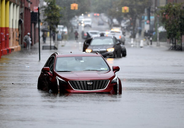
Abandoned cars on a flooded street in Brooklyn, NY.
Abandoned cars on a flooded street in Brooklyn, NY.Abandoned cars on a flooded street in the Gowanus neighborhood of Brooklyn, NY during a storm in 2023.
Abandoned cars on a flooded street in Brooklyn, NY.
Abandoned cars on a flooded street in Brooklyn, NY.Abandoned cars on a flooded street in the Gowanus neighborhood of Brooklyn, NY during a storm in 2023.

Hydrologic Technician Documenting a High-Water Mark in Montpelier
Hydrologic Technician Documenting a High-Water Mark in MontpelierUSGS staff documenting a high-water mark in Montpelier, Vermont, after significant flooding.
Hydrologic Technician Documenting a High-Water Mark in Montpelier
Hydrologic Technician Documenting a High-Water Mark in MontpelierUSGS staff documenting a high-water mark in Montpelier, Vermont, after significant flooding.

Calibrating a continuous water quality monitor
New England WSC scientist calibrating a continuous water quality monitor at 410606073245700, Norwalk River at the Norwalk Aquarium.
New England WSC scientist calibrating a continuous water quality monitor at 410606073245700, Norwalk River at the Norwalk Aquarium.

Ryan Bottorff servicing a continuous water quality monitor at US Coast Guard Academy on the Thames River in Groton, CT
Ryan Bottorff servicing a continuous water quality monitor at US Coast Guard Academy on the Thames River in Groton, CTRyan Bottorff servicing a continuous water quality monitor at US Coast Guard Academy on the Thames River in Groton, CT.

New England Water Science Center Massachusetts/Rhode Island Office
New England Water Science Center Massachusetts/Rhode Island OfficeThe USGS New England Water Science Massachusetts/Rhode Island Office is located in Northborough, MA.
New England Water Science Center Massachusetts/Rhode Island Office
New England Water Science Center Massachusetts/Rhode Island OfficeThe USGS New England Water Science Massachusetts/Rhode Island Office is located in Northborough, MA.

Flood Damage of Cobble Ridge Road Bridge over West River in Londonderry, Vermont
Flood Damage of Cobble Ridge Road Bridge over West River in Londonderry, VermontA USGS hydrologist stands in front of debris and damage of Cobble Ridge Road Bridge over the West River in Londonderry, Vermont. This destruction occurred from flood waters that rose from a heavy-rainfall event in July 2023.