地震发生区域
国家地震灾害模型,2023 年
纽约市的地震
您知道自己生活在“地震带”吗?这是真 的。纽约市等地过去曾发生过地震,将来 还会发生。如果您感到地面在震动,请确 保知道怎么做:趴下、掩护和稳住!
如果您感觉到地面在震动
趴下 掩护 稳住
规模最大的地震 - 纽约市 - 1884年8月10日 - 震级 5.2

Official websites use .gov
A .gov website belongs to an official government organization in the United States.
Secure .gov websites use HTTPS
A lock () or https:// means you’ve safely connected to the .gov website. Share sensitive information only on official, secure websites.
Images below come from a wide variety of USGS science activities in the Northeast Region. Science Center staff showcase what we do, who we are, and where we work conducting science that inform decision makers and addresses societal needs.

地震发生区域
国家地震灾害模型,2023 年
纽约市的地震
您知道自己生活在“地震带”吗?这是真 的。纽约市等地过去曾发生过地震,将来 还会发生。如果您感到地面在震动,请确 保知道怎么做:趴下、掩护和稳住!
如果您感觉到地面在震动
趴下 掩护 稳住
规模最大的地震 - 纽约市 - 1884年8月10日 - 震级 5.2
地震发生区域
国家地震灾害模型,2023 年
纽约市的地震
您知道自己生活在“地震带”吗?这是真 的。纽约市等地过去曾发生过地震,将来 还会发生。如果您感到地面在震动,请确 保知道怎么做:趴下、掩护和稳住!
如果您感觉到地面在震动
趴下 掩护 稳住
规模最大的地震 - 纽约市 - 1884年8月10日 - 震级 5.2
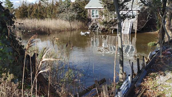
Flooded front yard of a house near the Wading River after a massive winter storm in January 2024.
Flooded front yard of a house near the Wading River after a massive winter storm in January 2024.
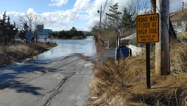
Flooding after the winter storm of January 12th, 2024, in Wading River along Creek Road and Sound Road.
Flooding after the winter storm of January 12th, 2024, in Wading River along Creek Road and Sound Road.

View from bridge at USGS streamgage (station ID: 01634000) of North Fork of the Shenandoah River after a rainstorm.
Winter 2024 Photo Contest: James Webber, Honorable Mention category
View from bridge at USGS streamgage (station ID: 01634000) of North Fork of the Shenandoah River after a rainstorm.
Winter 2024 Photo Contest: James Webber, Honorable Mention category

Two scientists taking a critical ADCP measurement at Shetucket River in Taftville, CT. This measurement was the highest flow measured at this site at 11,400 cfs. Due to high velocities the measurement required two people manning the cableway to maintain a smooth and consistent track across the river.
Two scientists taking a critical ADCP measurement at Shetucket River in Taftville, CT. This measurement was the highest flow measured at this site at 11,400 cfs. Due to high velocities the measurement required two people manning the cableway to maintain a smooth and consistent track across the river.

Hydrologic Technician Allison Carter taking a water level measurement with a calibrated electric tape at the real-time groundwater well station located in Orange, Massachusetts. (Station ID#: 423441072170701 MA-ORW 63)
Winter 2024 Photo Contest Winner: Sam Banas, Where We Work category
Hydrologic Technician Allison Carter taking a water level measurement with a calibrated electric tape at the real-time groundwater well station located in Orange, Massachusetts. (Station ID#: 423441072170701 MA-ORW 63)
Winter 2024 Photo Contest Winner: Sam Banas, Where We Work category
A groundwater well at the Savage Municipal Water Supply Superfund Site ejects water as a result of air sparging taking place in an adjacent well. Air sparging is a technique used in soil remediation that sneds pressurized air into the ground to remove soil contaminants.
A groundwater well at the Savage Municipal Water Supply Superfund Site ejects water as a result of air sparging taking place in an adjacent well. Air sparging is a technique used in soil remediation that sneds pressurized air into the ground to remove soil contaminants.

A hydrologic technician measures a high-water mark near the Androscoggin River in Topsham, Maine days after a significant flood event in late December 2023. A combination of heavy rainfall and snowmelt prompted the flooding.
A hydrologic technician measures a high-water mark near the Androscoggin River in Topsham, Maine days after a significant flood event in late December 2023. A combination of heavy rainfall and snowmelt prompted the flooding.

A USGS hydrologist records a high-water mark on a tree near the Crooked River in Waterford, Maine in the days following a significant flood event.
A USGS hydrologist records a high-water mark on a tree near the Crooked River in Waterford, Maine in the days following a significant flood event.

A hydrologic technician measures a high-water mark on a business in Anson, Maine after a significant flood event in late December 2023 flooded the Kennebec River.
A hydrologic technician measures a high-water mark on a business in Anson, Maine after a significant flood event in late December 2023 flooded the Kennebec River.

Physical Scientist Shannon Fisher taking a water level measurement with a calibrated electric tape at the monthly discrete groundwater observation well located in Foster, Rhode Island. (Station ID#: 414420071422301 RI-FOW 40)
Winter 2024 Photo Contest: Sam Banas, Honorable Mention category
Physical Scientist Shannon Fisher taking a water level measurement with a calibrated electric tape at the monthly discrete groundwater observation well located in Foster, Rhode Island. (Station ID#: 414420071422301 RI-FOW 40)
Winter 2024 Photo Contest: Sam Banas, Honorable Mention category

A heavy rainstorm, saturated ground, and pre-existing snowpack prompted flooding in Maine in late December 2023. USGS researchers manually measured streamflows after the flood event to validate real-time streamgage data.
A heavy rainstorm, saturated ground, and pre-existing snowpack prompted flooding in Maine in late December 2023. USGS researchers manually measured streamflows after the flood event to validate real-time streamgage data.

A hydrologic technician identifies a high-water mark at a gas station in Plymouth, New Hampshire following a flood event in late December 2023.
A hydrologic technician identifies a high-water mark at a gas station in Plymouth, New Hampshire following a flood event in late December 2023.

This USGS webcam footage shows the Kennebec River in Augusta, Maine, flooding after a large coastal storm hit much of the East Coast and battered New England with heavy rains and winds. USGS image.
This USGS webcam footage shows the Kennebec River in Augusta, Maine, flooding after a large coastal storm hit much of the East Coast and battered New England with heavy rains and winds. USGS image.

Trent Watts, a USGS hydrologic technician, uses an Acoustic Doppler Current Profiler to measure the amount of water flowing in Perkiomen Creek in Graterford, Pennsylvania, on December 18. USGS photo by Cameron Ensor.
Trent Watts, a USGS hydrologic technician, uses an Acoustic Doppler Current Profiler to measure the amount of water flowing in Perkiomen Creek in Graterford, Pennsylvania, on December 18. USGS photo by Cameron Ensor.

The Kennebec River flooded in downtown Augusta, Maine, after a heavy rainstorm. USGS streamgage 01049320 monitors the streamflow of this area
The Kennebec River flooded in downtown Augusta, Maine, after a heavy rainstorm. USGS streamgage 01049320 monitors the streamflow of this area

Flooding surrounds USGS streamgage 01029500 on the East Branch of the Penobscot River in Grindstone, Maine. The river flooded after a significant rainstorm added several inches of rain and melted snowpack in late December 2023.
Flooding surrounds USGS streamgage 01029500 on the East Branch of the Penobscot River in Grindstone, Maine. The river flooded after a significant rainstorm added several inches of rain and melted snowpack in late December 2023.

Piscataquis River in Maine during flood following a powerful rainstorm. Vicinity of the USGS streamgage 01031500, Piscataquis River near Dover-Foxcroft, Maine on December 19, 2023.
Piscataquis River in Maine during flood following a powerful rainstorm. Vicinity of the USGS streamgage 01031500, Piscataquis River near Dover-Foxcroft, Maine on December 19, 2023.

Photo taken in Hallowell, Maine on December 19, 2023, following a powerful rainstorm.
Photo taken in Hallowell, Maine on December 19, 2023, following a powerful rainstorm.

The streets of Hallowell, Maine, were flooded following heavy rains that hit New England and most of the East Coast, December 18, 2023. USGS photo by Glenn Hodgkins
The streets of Hallowell, Maine, were flooded following heavy rains that hit New England and most of the East Coast, December 18, 2023. USGS photo by Glenn Hodgkins

The Kennebec River flooded in downtown Hallowell, Maine, after a heavy rainstorm. USGS streamgage 01049330 monitors the streamflow of this area.
The Kennebec River flooded in downtown Hallowell, Maine, after a heavy rainstorm. USGS streamgage 01049330 monitors the streamflow of this area.