
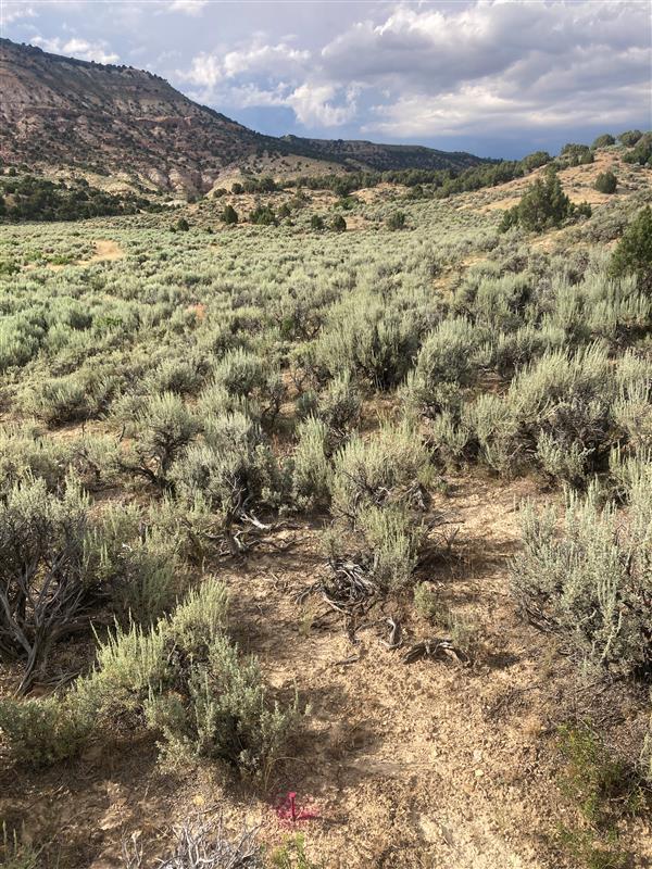
This landscape in Rabbit Valley in Colorado was burned and then invaded by the exotic annual grass cheatgrass. A formerly diverse plant community was replaced by a sea of highly flammable grass.
Images
Explore images.
Filter Total Items: 183

Burned landscape invaded by cheatgrass
This landscape in Rabbit Valley in Colorado was burned and then invaded by the exotic annual grass cheatgrass. A formerly diverse plant community was replaced by a sea of highly flammable grass.

Vegetation and soil data collection at Castle Rocks, Idaho
Vegetation and soil data collection at Castle Rocks, IdahoA Project ROAM (Rapid and Other Methods for Assessment and Monitoring) crew collecting vegetation data at a complex plot with over 40 unique species.
Vegetation and soil data collection at Castle Rocks, Idaho
Vegetation and soil data collection at Castle Rocks, IdahoA Project ROAM (Rapid and Other Methods for Assessment and Monitoring) crew collecting vegetation data at a complex plot with over 40 unique species.
Undisturbed sagebrush landscape in Wyoming
This site south of Rock Springs in Wyoming represents an intact sagebrush ecosystem. It has not been burned or invaded by exotic annual grasses. Undisturbed sagebrush steppe has bare ground between shrubs which helps to limit the spread of wildfire. When cheatgrass invades fires can grow larger.
This site south of Rock Springs in Wyoming represents an intact sagebrush ecosystem. It has not been burned or invaded by exotic annual grasses. Undisturbed sagebrush steppe has bare ground between shrubs which helps to limit the spread of wildfire. When cheatgrass invades fires can grow larger.

Kīlauea summit eruption in Halema‘uma‘u - June 7, 2023
Kīlauea summit eruption in Halema‘uma‘u - June 7, 2023A summit eruption of Kīlauea volcano, within Halemaʻumaʻu crater, began at approximately 4:44 a.m. on June 7, 2023. Lava is flowing on the crater floor and there are several active vent sources. The eruption at Kīlauea’s summit is occurring within a closed area of Hawai'i Volcanoes National Park and high levels of volcanic gas are the primary hazard of concern.
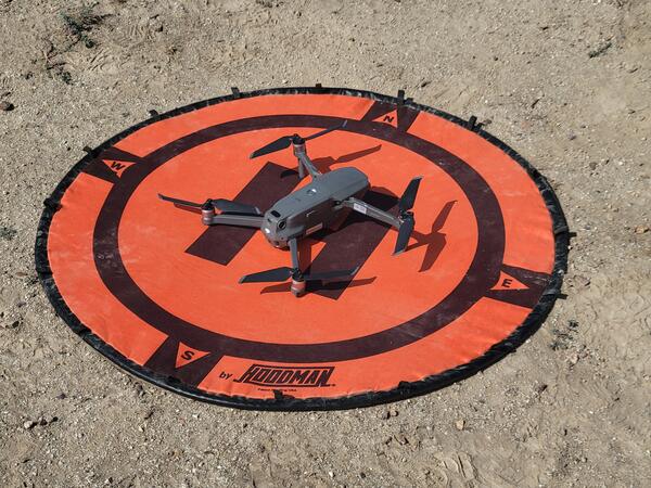
Drone ready to fly
A quadcopter drone rests on the orange landing pad, ready to fly over Rapid and Other Methods for Assessment and Monitoring (ROAM) plots to collect data that will be used to generate cover and density estimates.
A quadcopter drone rests on the orange landing pad, ready to fly over Rapid and Other Methods for Assessment and Monitoring (ROAM) plots to collect data that will be used to generate cover and density estimates.

Waiting on the wing
A large quadcopter drone rests on the tailgate of a truck waiting to fly with hyperspectral imagery to estimate vegetation cover.
A large quadcopter drone rests on the tailgate of a truck waiting to fly with hyperspectral imagery to estimate vegetation cover.

Smallmouth Bass
Smallmouth Bass are good indicators of methylmercury exposure to humans and wildlife because they are a common, popular sport fish and eat a variety of food during their lifetime. Juvenile Smallmouth Bass – smaller than 150mm in length - eat zooplankton, or microscopic animals.
Smallmouth Bass are good indicators of methylmercury exposure to humans and wildlife because they are a common, popular sport fish and eat a variety of food during their lifetime. Juvenile Smallmouth Bass – smaller than 150mm in length - eat zooplankton, or microscopic animals.

Brown treesnake crossing wires
Example of a brown treesnake (Boiga irregularis) wrapped around two wires. This image is an example of how adult brown treesnakes can bridge power lines and cause power outages. The brown treesnake is an arboreal invasive species on Guam where researchers have discovered electrocuted snakes on power lines and at substations.
Example of a brown treesnake (Boiga irregularis) wrapped around two wires. This image is an example of how adult brown treesnakes can bridge power lines and cause power outages. The brown treesnake is an arboreal invasive species on Guam where researchers have discovered electrocuted snakes on power lines and at substations.

Culex mosquito eggs
A group of controlled Culex mosquito eggs are viewed under a microscope in a California laboratory as part of an effort to mitigate avian malaria throughout the Hawaiian Islands. Image by Mia Takai
A group of controlled Culex mosquito eggs are viewed under a microscope in a California laboratory as part of an effort to mitigate avian malaria throughout the Hawaiian Islands. Image by Mia Takai

Surveying for plants in a cheatgrass invaded landscape
Surveying for plants in a cheatgrass invaded landscapeResearchers identified plants along a transect at a site invaded by cheatgrass at Kuna Butte near Caldwell, Idaho.
Surveying for plants in a cheatgrass invaded landscape
Surveying for plants in a cheatgrass invaded landscapeResearchers identified plants along a transect at a site invaded by cheatgrass at Kuna Butte near Caldwell, Idaho.

Klamath River below JC Boyle Powerplant
One of many stream gages in the Klamath Basin. Solar charged batteries keep the data coming in through the satellite network. View the data.
One of many stream gages in the Klamath Basin. Solar charged batteries keep the data coming in through the satellite network. View the data.

Lone goose at sunrise at Summer Lake Wildlife Area
Lone goose at sunrise at Summer Lake Wildlife AreaLooking east on Bullgate Pond at sunrise with lone tule white-fronted goose (Anser albifrons elgasi) in upper right, Summer Lake Wildlife Area, near Summer Lake, Oregon.
By
Ecosystems Mission Area, Water Resources Mission Area, Species Management Research Program, Water Availability and Use Science Program, Forest and Rangeland Ecosystem Science Center, Fort Collins Science Center, Nevada Water Science Center, Oregon Water Science Center, Utah Water Science Center, Western Ecological Research Center (WERC), Saline Lake Ecosystems Integrated Water Availability Assessment

North Santiam River
Looking up river on the North Santiam in Gates, Oregon. The small metal box houses stream monitoring telemetry equipment.
Looking up river on the North Santiam in Gates, Oregon. The small metal box houses stream monitoring telemetry equipment.

An ADCP measures the Sevenmile Canal
A YSI Sontek M9 acoustic doppler current profiler (ADCP) measures the flow along the Sevenmile Canal. The Sevenmile Canal is a tributary to Upper Klamath Lake.
A YSI Sontek M9 acoustic doppler current profiler (ADCP) measures the flow along the Sevenmile Canal. The Sevenmile Canal is a tributary to Upper Klamath Lake.

Automated radio telemetry base station
A major advancement in the use of radio telemetry has been the development of automated radio tracking systems (ARTS) which allow animal movements to be tracked continuously. A new ARTS approach is the use of a network of simple radio receivers (nodes) that collect radio signal strength (RSS) values from animal-borne radio transmitters.
A major advancement in the use of radio telemetry has been the development of automated radio tracking systems (ARTS) which allow animal movements to be tracked continuously. A new ARTS approach is the use of a network of simple radio receivers (nodes) that collect radio signal strength (RSS) values from animal-borne radio transmitters.

Adult Lahontan cutthroat trout
Lahontan cutthroat trout (Oncorhynchus clarkii henshawi) is a federally listed threatened species. Ninety-seven percent of their range are small headwater streams in the Great Basin of North America.
Lahontan cutthroat trout (Oncorhynchus clarkii henshawi) is a federally listed threatened species. Ninety-seven percent of their range are small headwater streams in the Great Basin of North America.

Dragonfly Mercury Project specimen collection in Glacier NP
Dragonfly Mercury Project specimen collection in Glacier NPResearchers instruct volunteers on how to collect dragonfly larvae in Glacier NP as a part of the Dragonfly Mercury Project.
Dragonfly Mercury Project specimen collection in Glacier NP
Dragonfly Mercury Project specimen collection in Glacier NPResearchers instruct volunteers on how to collect dragonfly larvae in Glacier NP as a part of the Dragonfly Mercury Project.

A geologists makes observations at Kilauea
Clear weather allowed HVO geologists to make observations and take measurements of the water pond at Kīlauea's summit. No major changes were observed, and the water level continues to slowly rise. Note the former HVO observation tower can be seen above the geologist's helmet.
Clear weather allowed HVO geologists to make observations and take measurements of the water pond at Kīlauea's summit. No major changes were observed, and the water level continues to slowly rise. Note the former HVO observation tower can be seen above the geologist's helmet.

Unoccupied Aircraft System with water sampler
The sampling mechanism (on blue tarp) is prepared and the Unoccupied Aircraft System (UAS) is inspected just before take off to collect water from the Halema‘uma‘u crater lake. Brightly colored flagging tape tied to a cable attached to the UAS indicated depth as the sampling tool was lowered into the water.
The sampling mechanism (on blue tarp) is prepared and the Unoccupied Aircraft System (UAS) is inspected just before take off to collect water from the Halema‘uma‘u crater lake. Brightly colored flagging tape tied to a cable attached to the UAS indicated depth as the sampling tool was lowered into the water.

Scientists process volcano lake water samples
After a sample was collected, HVO team members transferred water from the sampling device to plastic bottles. Team members took notes, measured water pH and evaluated water temperature data for each sample collected.
After a sample was collected, HVO team members transferred water from the sampling device to plastic bottles. Team members took notes, measured water pH and evaluated water temperature data for each sample collected.