
A storm rolls in during field work at the Charles M. Russell National Wildlife Refuge in Montana. Crews were measuring plant cover and other site characteristics. Sagebrush and yellow sweet clover are visible.
Images
Explore images.
Filter Total Items: 195

Storm over sagebrush steppe in Montana
A storm rolls in during field work at the Charles M. Russell National Wildlife Refuge in Montana. Crews were measuring plant cover and other site characteristics. Sagebrush and yellow sweet clover are visible.
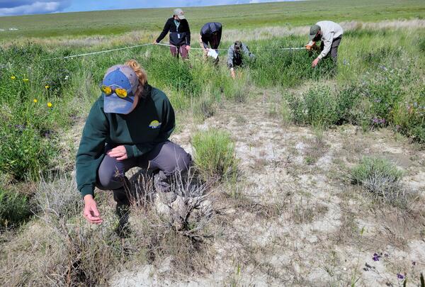
ROAM field data collection
A five-person USGS crew collecting Rapid and Other Assessment and Monitoring (ROAM) density data in southwest Idaho. One person is inspecting a plant in the foreground, while the rest of the team are identifying and counting individual plants during a radial density belt.
A five-person USGS crew collecting Rapid and Other Assessment and Monitoring (ROAM) density data in southwest Idaho. One person is inspecting a plant in the foreground, while the rest of the team are identifying and counting individual plants during a radial density belt.
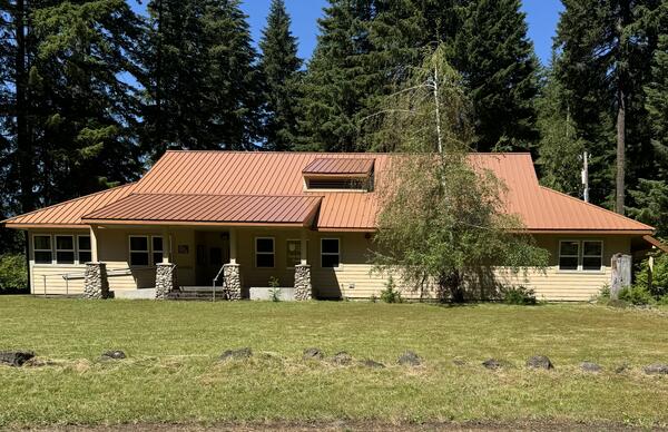
USGS WFRC Columbia River Research Laboratory
This is a photo of the new USGS Western Fisheries Research Center Columbia River Research Laboratory building.
This is a photo of the new USGS Western Fisheries Research Center Columbia River Research Laboratory building.

Downward facing photo within a ROAM plot
A downward-facing photo taken on a Rapid and Other Methods for Assessment and Monitoring (ROAM) plot that is within a fuel break. The photo includes a lot of gravel and bare ground, with intermixed small grasses, forbs, and shrubs.
A downward-facing photo taken on a Rapid and Other Methods for Assessment and Monitoring (ROAM) plot that is within a fuel break. The photo includes a lot of gravel and bare ground, with intermixed small grasses, forbs, and shrubs.

Shore of Lake Abert, Oregon
Lake Abert, Oregon is one of the 20 terminal lakes identified by USGS partners as priority ecosystems for study by the Saline Lakes Ecosystems IWAA.
By
Ecosystems Mission Area, Water Resources Mission Area, Forest and Rangeland Ecosystem Science Center, Fort Collins Science Center, Nevada Water Science Center, Oregon Water Science Center, Utah Water Science Center, Western Ecological Research Center (WERC), Saline Lake Ecosystems Integrated Water Availability Assessment

Goose Lake, Oregon-California
Goose Lake, on the Oregon-California border, is one of the 20 terminal lakes identified by USGS partners as priority ecosystems for study by the Saline Lakes Ecosystems IWAA.
By
Ecosystems Mission Area, Water Resources Mission Area, Species Management Research Program, Water Resources Research Act Program, Forest and Rangeland Ecosystem Science Center, Fort Collins Science Center, Nevada Water Science Center, Oregon Water Science Center, Utah Water Science Center, Western Ecological Research Center (WERC), Saline Lake Ecosystems Integrated Water Availability Assessment

Recently germinated sagebrush plants
Many new big sagebrush (Artemisia tridentata) plants that have just sprouted from the ground in the Morley Nelson Snake River Birds of Prey National Conservation Area in Idaho.
Many new big sagebrush (Artemisia tridentata) plants that have just sprouted from the ground in the Morley Nelson Snake River Birds of Prey National Conservation Area in Idaho.
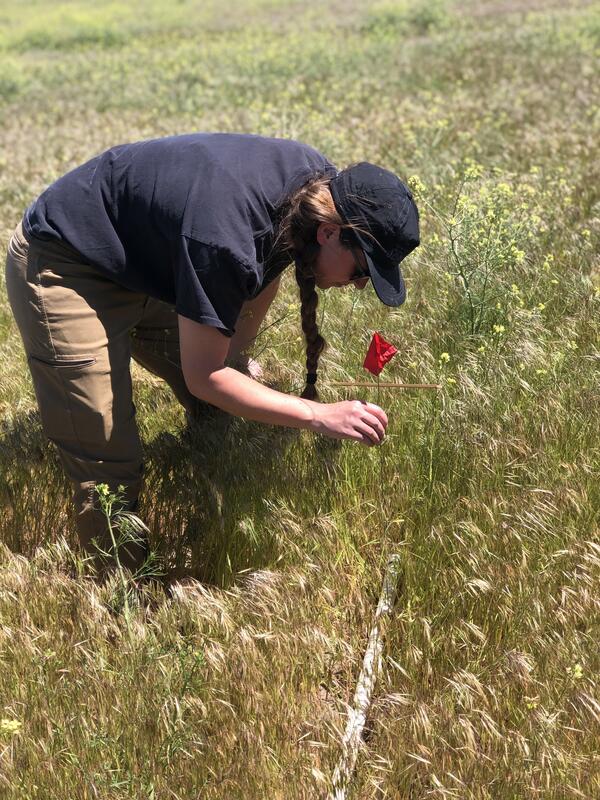
Stick-point intercept vegetation survey in Idaho
A field crew member collecting stick-point intercept data at a Project ROAM (Rapid and Other Methods for Assessment and Monitoring) plot. A meter-long 'stick' is dropped and five recordings of vegetation are collected by dropping a pin flag along the stick. The vegetation it comes into contact with is recorded to estimate cover.
A field crew member collecting stick-point intercept data at a Project ROAM (Rapid and Other Methods for Assessment and Monitoring) plot. A meter-long 'stick' is dropped and five recordings of vegetation are collected by dropping a pin flag along the stick. The vegetation it comes into contact with is recorded to estimate cover.

Director Applegate and Staff from Western Fisheries Research Center
Director Applegate and Staff from Western Fisheries Research CenterDirector Applegate and staff from Western Fisheries Research Center pose in front of the newly painted mural at the Western Fisheries Research Center’s headquarters. The mural features three swimming salmon, a DNA helix, a microscope, and the USGS logo.

Director Visits Western Fisheries Research Center, 2024
Director Visits Western Fisheries Research Center, 2024Director Applegate visited Western Fisheries Research Center Headquarters in Seattle, WA.
Director Visits Western Fisheries Research Center, 2024
Director Visits Western Fisheries Research Center, 2024Director Applegate visited Western Fisheries Research Center Headquarters in Seattle, WA.

Director Visits Western Fisheries Research Center Wet Lab, 2024
Director Visits Western Fisheries Research Center Wet Lab, 2024Director Applegate visited Western Fisheries Research Center Headquarters in Seattle, WA.
Director Visits Western Fisheries Research Center Wet Lab, 2024
Director Visits Western Fisheries Research Center Wet Lab, 2024Director Applegate visited Western Fisheries Research Center Headquarters in Seattle, WA.

Director Applegate Visits Western Fisheries Research Center Wet Lab, 2024
Director Applegate Visits Western Fisheries Research Center Wet Lab, 2024Director Applegate visited Western Fisheries Research Center Headquarters in Seattle, WA.
Director Applegate Visits Western Fisheries Research Center Wet Lab, 2024
Director Applegate Visits Western Fisheries Research Center Wet Lab, 2024Director Applegate visited Western Fisheries Research Center Headquarters in Seattle, WA.

An Orchestra of Conservation for the Melodies of Hakalau Forest.PNG
An Orchestra of Conservation for the Melodies of Hakalau Forest.PNGUSGS and USFWS logos with title "An Orchestra of Conservation for the Melodies of Hakalau Forest" featured on an image of a red apapane bird against a blue sky background

A hovercraft glides over the surface of Summer Lake, Oregon
A hovercraft glides over the surface of Summer Lake, OregonSummer Lake, Oregon is one of the 20 terminal lakes identified by USGS partners as priority ecosystems for study by the Saline Lakes Ecosystems IWAA.
By
Ecosystems Mission Area, Water Resources Mission Area, Species Management Research Program, Water Availability and Use Science Program, Forest and Rangeland Ecosystem Science Center, Fort Collins Science Center, Nevada Water Science Center, Oregon Water Science Center, Utah Water Science Center, Western Ecological Research Center (WERC), Saline Lake Ecosystems Integrated Water Availability Assessment

'apanane
A red, native 'apanane bird sits on pink and white shrubbery against a bright blue sky in Hawaii.
A red, native 'apanane bird sits on pink and white shrubbery against a bright blue sky in Hawaii.

Photo of people birding in the Big Island National Wildlife Refuge
Photo of people birding in the Big Island National Wildlife RefugePhoto of people birding in the Big Island National Wildlife Refuge in Hawai'i. Individuals hold binoculars and look out into the forested area.
Photo of people birding in the Big Island National Wildlife Refuge
Photo of people birding in the Big Island National Wildlife RefugePhoto of people birding in the Big Island National Wildlife Refuge in Hawai'i. Individuals hold binoculars and look out into the forested area.

Volunteers lean over to plant trees in grassy area of a forest in Hawai'i
Volunteers lean over to plant trees in grassy area of a forest in Hawai'iVolunteers lean over to plant trees in grassy area of a forest in Hawai'i. These trees provide crucial habitat for native birds within the refuge.
Volunteers lean over to plant trees in grassy area of a forest in Hawai'i
Volunteers lean over to plant trees in grassy area of a forest in Hawai'iVolunteers lean over to plant trees in grassy area of a forest in Hawai'i. These trees provide crucial habitat for native birds within the refuge.

Volunteers and scientists stand amidst tall trees in a Hawaiian forest
Volunteers and scientists stand amidst tall trees in a Hawaiian forestVolunteers and scientists stand amidst tall trees in a Hawaiian forest where habitat restoration is taking place for native birds.
Volunteers and scientists stand amidst tall trees in a Hawaiian forest
Volunteers and scientists stand amidst tall trees in a Hawaiian forestVolunteers and scientists stand amidst tall trees in a Hawaiian forest where habitat restoration is taking place for native birds.

Hawai‘i ‘ākepa sits in tropical forested area
Bright orange native Hawai‘i ‘ākepa sits in lush green tropical forested area in Hawai'i.
Bright orange native Hawai‘i ‘ākepa sits in lush green tropical forested area in Hawai'i.

Lahar Evacuation Drill
During the March 21, 2024 lahar evacuation drills, thousands of students walked to the Washington State Fairgrounds in Puyallup, Washington to practice evacuating from a lahar generated by Mount Rainier. A lahar, or volcanic mudflow, could reach this area in about 3 hours.
During the March 21, 2024 lahar evacuation drills, thousands of students walked to the Washington State Fairgrounds in Puyallup, Washington to practice evacuating from a lahar generated by Mount Rainier. A lahar, or volcanic mudflow, could reach this area in about 3 hours.

Kahanahaiki_Oahu.JPG
Photo of green forested area and blue sky overlooking the ocean in Kahanahāiki, Oʻahu on a sunny day.
Photo of green forested area and blue sky overlooking the ocean in Kahanahāiki, Oʻahu on a sunny day.