
View from the Gold King Mine showing water flowing toward viewer in culvert that collects water from the draining Gold King mine tunnel and diverts water around the waste pile on which it flows and which falls off to the left of the photo. Latitude 37.894631, Longitude -107.638288.
Images
Images described and linked on this webpage come from a wide variety of USGS science activities and presentations performed by USGS Science Center staff members in the Region 7: Upper Colorado Basin. A search tool is provided to narrow the number of image files shown.
Filter Total Items: 548

View from Gold King Mine
View from the Gold King Mine showing water flowing toward viewer in culvert that collects water from the draining Gold King mine tunnel and diverts water around the waste pile on which it flows and which falls off to the left of the photo. Latitude 37.894631, Longitude -107.638288.

GKM Waste Pile
View of the waste pile below the Gold King Mine. Latitude 37.894429, Longitude -107.639135.
View of the waste pile below the Gold King Mine. Latitude 37.894429, Longitude -107.639135.

GKM culvert draining
View of flume installation to measure discharge/flow in the culvert that collects flow from the Gold King Mine. Latitude 37.894631, Longitude -107.638288.
View of flume installation to measure discharge/flow in the culvert that collects flow from the Gold King Mine. Latitude 37.894631, Longitude -107.638288.

Gold King Mine Pond Edge
View of pond in North Fork of Cement Creek that receives the water from the Gold King Mine portal and native flow in North Fork Cement Creek, looking upstream, very little to no native flow is visible. Latitude 37.89401, Longitude -107.63821.
View of pond in North Fork of Cement Creek that receives the water from the Gold King Mine portal and native flow in North Fork Cement Creek, looking upstream, very little to no native flow is visible. Latitude 37.89401, Longitude -107.63821.

Cement Creek
North Fork Cement Creek just upstream from sodium hydroxide (NaOH) addition (to raise pH), that was conducted by the U.S. Environmental Protection Agency (EPA). Looking upstream. Latitude 37.89517, Longitude -107.64656.
North Fork Cement Creek just upstream from sodium hydroxide (NaOH) addition (to raise pH), that was conducted by the U.S. Environmental Protection Agency (EPA). Looking upstream. Latitude 37.89517, Longitude -107.64656.

Cement Creek near CC48
Cement Creek near the mouth at site CC48 (USGS site ID 09358550), location of stream gage whose data allowed calculation of the volume of water released during the Gold King Mine release. Latitude 37.8197222, Longitude -107.663056.
Cement Creek near the mouth at site CC48 (USGS site ID 09358550), location of stream gage whose data allowed calculation of the volume of water released during the Gold King Mine release. Latitude 37.8197222, Longitude -107.663056.

Cement Creek Downstream
Cement Creek downstream from CC48 Gage (USGS site ID 09358550) and upstream from confluence with the Animas River near Silverton. Latitude 37.81975, Longitude -107.6624.
Cement Creek downstream from CC48 Gage (USGS site ID 09358550) and upstream from confluence with the Animas River near Silverton. Latitude 37.81975, Longitude -107.6624.

First Pond below Gold King Mine
First of four settling ponds located downstream from North Fork Cement Creek to facilitate settling of solids material after addition of sodium hydroxide (NaOH) to the North Fork Cement Creek. Latitude 37.89451, Longitude -107.64763.
First of four settling ponds located downstream from North Fork Cement Creek to facilitate settling of solids material after addition of sodium hydroxide (NaOH) to the North Fork Cement Creek. Latitude 37.89451, Longitude -107.64763.

North Fork of Cement Creek
View looking down from the Gold King waste pile showing North Fork Cement Creek downstream from the pond, and the confluence with Cement Creek valley in center, upper, right. Latitude 37.893895, Longitude -107.641154.
View looking down from the Gold King waste pile showing North Fork Cement Creek downstream from the pond, and the confluence with Cement Creek valley in center, upper, right. Latitude 37.893895, Longitude -107.641154.

Water Sample Comparison
Photo showing contrast in clarity between water samples collected at sites A68 (USGS site ID 09358000), Animas River at Silverton, Colorado and upstream from Cement Creek; A72 (USGS site ID 09359020), Animas River downstream from Silverton; and CC48 (USGS site ID 09358550), Cement Creek at mouth.
Photo showing contrast in clarity between water samples collected at sites A68 (USGS site ID 09358000), Animas River at Silverton, Colorado and upstream from Cement Creek; A72 (USGS site ID 09359020), Animas River downstream from Silverton; and CC48 (USGS site ID 09358550), Cement Creek at mouth.

Island Streambed Sampling
Island upstream from City of Durango, Colorado's water intake structure where streambed sediments were sampled. Latitude 37.26428, Longitude -107.8812.
Island upstream from City of Durango, Colorado's water intake structure where streambed sediments were sampled. Latitude 37.26428, Longitude -107.8812.

Minisipper at Durango
Minisipper location at City of Durango water intake structure. Minisipper installed by USGS to collect multiple water-quality samples. Latitude 37.26428, Longitude -107.8812.
Minisipper location at City of Durango water intake structure. Minisipper installed by USGS to collect multiple water-quality samples. Latitude 37.26428, Longitude -107.8812.

Minisipper
Photo of submersible Minisipper sampling device used to collect multiple water-quality samples during multiple-day deployment. At several locations downstream from the Gold King Mine following the Gold King Mine release on August 5, 2015.
Photo of submersible Minisipper sampling device used to collect multiple water-quality samples during multiple-day deployment. At several locations downstream from the Gold King Mine following the Gold King Mine release on August 5, 2015.

USGS scientist records vegetation data on decommissioned well pad
USGS scientist records vegetation data on decommissioned well padUSGS soil scientist Travis Nauman records vegetation data on decommissioned well pad.
USGS scientist records vegetation data on decommissioned well pad
USGS scientist records vegetation data on decommissioned well padUSGS soil scientist Travis Nauman records vegetation data on decommissioned well pad.

USGS scientist collects data on decommissioned well pad
USGS scientist collects data on decommissioned well padUSGS scientist Jessica Mikenas collects surface soil pH data on decommissioned well pad.
USGS scientist collects data on decommissioned well pad
USGS scientist collects data on decommissioned well padUSGS scientist Jessica Mikenas collects surface soil pH data on decommissioned well pad.

USGS scientist records vegetation data on decommissioned well pad
USGS scientist records vegetation data on decommissioned well padUSGS soil scientist Travis Nauman records vegetation data on decommissioned well pad.
USGS scientist records vegetation data on decommissioned well pad
USGS scientist records vegetation data on decommissioned well padUSGS soil scientist Travis Nauman records vegetation data on decommissioned well pad.

Examining biological soil crust near an abandoned well pad
Examining biological soil crust near an abandoned well padUSGS soil scientist Travis Nauman examines biological soil crust communities near an abandoned well pad during field work.
Examining biological soil crust near an abandoned well pad
Examining biological soil crust near an abandoned well padUSGS soil scientist Travis Nauman examines biological soil crust communities near an abandoned well pad during field work.

Collecting glacial moraine boulder samples
This is an example of a boulder that is part of a glacial deposit in the southern Sawatch Mountains of Colorado. The moraine slopes down to the left side of the frame; this slope is modified from teh original depositional shape of the moraine deposit.
This is an example of a boulder that is part of a glacial deposit in the southern Sawatch Mountains of Colorado. The moraine slopes down to the left side of the frame; this slope is modified from teh original depositional shape of the moraine deposit.

Pitchfork Ranch, Wyoming
Over 30 organizations and agencies are testing a USGS-developed oral sylvatic plague vaccine (SPV) at sites such as the Pitchfork Ranch in Wyoming, pictured here. If successful, the SPV could help protect endangered black-footed ferret populations in the western
Over 30 organizations and agencies are testing a USGS-developed oral sylvatic plague vaccine (SPV) at sites such as the Pitchfork Ranch in Wyoming, pictured here. If successful, the SPV could help protect endangered black-footed ferret populations in the western

Stagecoach Lake, Steamboat, Colorado
Sunset at Stagecoach Lake, Steamboat, Colorado
Sunset at Stagecoach Lake, Steamboat, Colorado
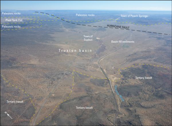
Aerial photograph of the Truxton Basin, northwestern Arizona, showing boundaries and geologic features
Aerial photograph of the Truxton Basin, northwestern Arizona, showing boundaries and geologic featuresAerial photograph of the Truxton basin, Arizona (view to northeast). Yellow dashed lines are approximate boundaries between labeled geologic features and units. From figure 2 in chapter B of Mason 2020