
May 2017
January 2021
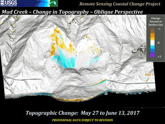
On May 20, 2017, the steep slopes at Mud Creek on California’s Big Sur coast, about 140 miles south of San Francisco, suffered a catastrophic collapse. USGS scientists from the Pacific Coastal and Marine Science Center and the Geology, Minerals, Energy, and Geophysics Science Center continue to monitor this section of the coastline, in collaboration with the California Department of Transportation.


The USGS Pacific Coastal and Marine Science Center captured an aerial photo set of the area on May 19, 2017, after a small landslide covered a portion of Highway 1. After the massive failure on May 20, the USGS collected more photographic data, and has continued to shoot additional photos from airplane and drones during the weeks and months following the catastrophic landslide. Since 2017, the USGS project scientists photograph the California coastline several times per year, and use “structure-from-motion” software to transform photos into 3D maps from which they can measure ground movement. These data sets help them track landslide activity in collaboration with scientists from the USGS Geology, Minerals, Energy, and Geophysics Science Center.
Read more about the Mud Creek landslide by selecting our news stories below.


Below are other science projects associated with this project.

Big Sur Landslides

Remote Sensing Coastal Change
On May 20, 2017, the steep slopes at Mud Creek on California’s Big Sur coast, about 140 miles south of San Francisco, suffered a catastrophic collapse. USGS scientists from the Pacific Coastal and Marine Science Center and the Geology, Minerals, Energy, and Geophysics Science Center continue to monitor this section of the coastline, in collaboration with the California Department of Transportation.
The USGS Pacific Coastal and Marine Science Center captured an aerial photo set of the area on May 19, 2017, after a small landslide covered a portion of Highway 1. After the massive failure on May 20, the USGS collected more photographic data, and has continued to shoot additional photos from airplane and drones during the weeks and months following the catastrophic landslide. Since 2017, the USGS project scientists photograph the California coastline several times per year, and use “structure-from-motion” software to transform photos into 3D maps from which they can measure ground movement. These data sets help them track landslide activity in collaboration with scientists from the USGS Geology, Minerals, Energy, and Geophysics Science Center.
Read more about the Mud Creek landslide by selecting our news stories below.
Below are other science projects associated with this project.
Big Sur Landslides